Training Log Archive: TheInvisibleLogIn the 7 days ending Jun 4, 2017:
| ||||||||||||||||||||||||||||||||||||||||||||||||||||||||||||||||||||||||||||||||||||||||||||
| « | » |
| » now | |||||||||||
| Mo | Tu | We | Th | Fr | Sa | Su | ||||||||
Sunday Jun 4, 2017 #
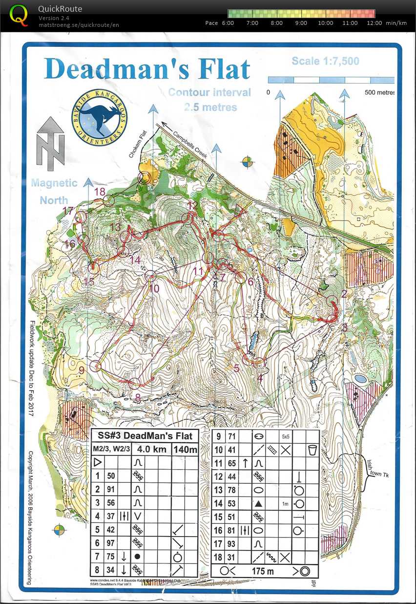
Real Orienteering (Deadmans Flat) 1:06:27 [3] **** 5.48 km (12:08 / km) +125m 10:53 / km
spiked:12/18c shoes: Salamon Speed Cross 4 Black
26th Bush event for 2017
Missed six controls. Four each cost 2 minutes each, the other two were just minor losses. All up nine minutes to errors, 14% of my time. I suppose its better than yesterday. I put it down to the Bendigo syndrome of going straight and hoping for the best. At least six munites could have been saved by the simple expedient of aiming off.
Missed six controls. Four each cost 2 minutes each, the other two were just minor losses. All up nine minutes to errors, 14% of my time. I suppose its better than yesterday. I put it down to the Bendigo syndrome of going straight and hoping for the best. At least six munites could have been saved by the simple expedient of aiming off.
7 AM
Walking 1:45:00 [1] 7.0 km (15:00 / km)
99
Saturday Jun 3, 2017 #
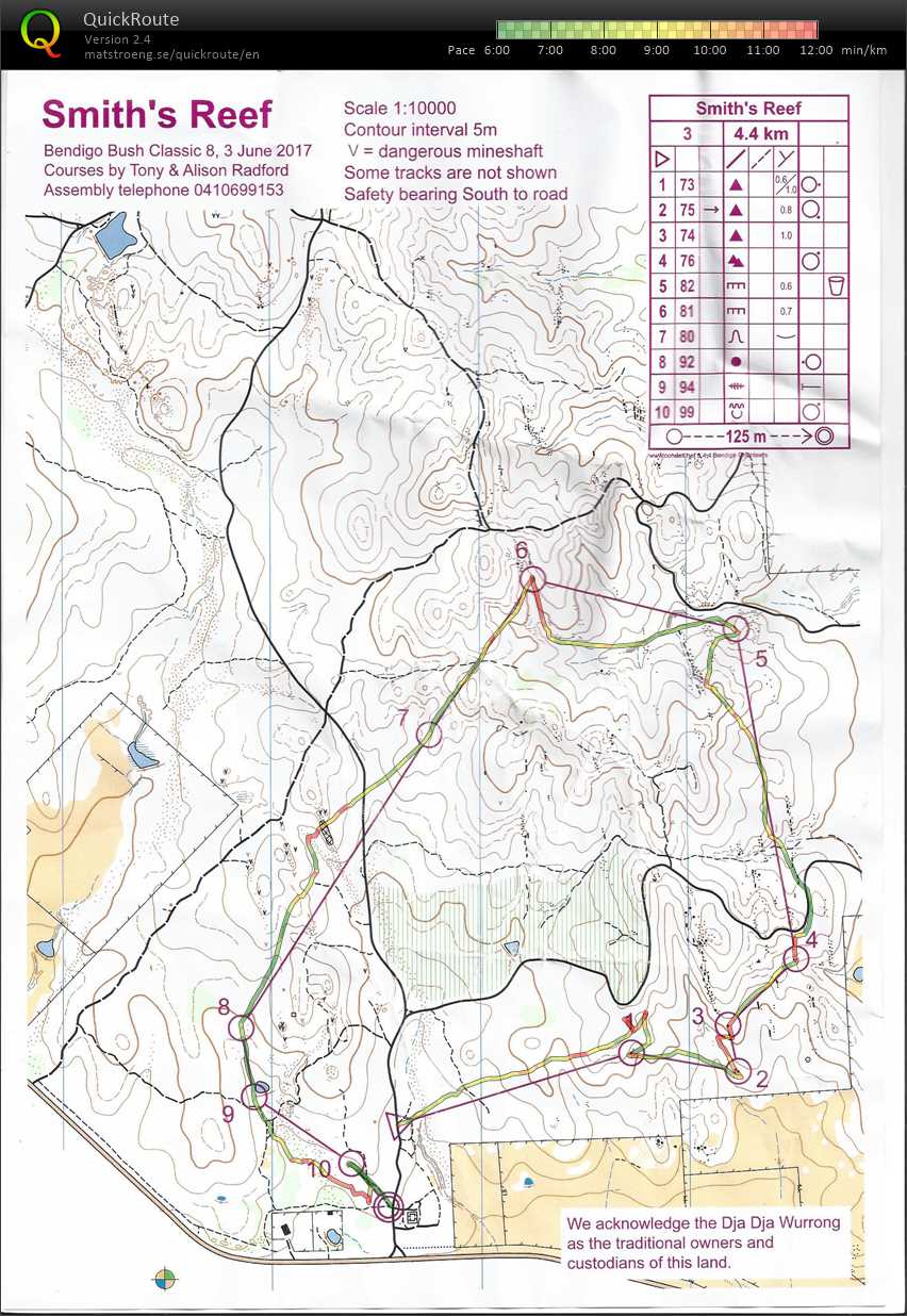
Real Orienteering (Smiths Reef) 45:29 [3] *** 5.35 km (8:30 / km) +140m 7:31 / km
spiked:5/10c shoes: Salamon Speed Cross 4 Black
25th bush event for the season. But not an auspicious run.
Fluffed half the controls, with 21% of my time being wasted. That's a new record for the year, and it was on relatively benign spur-gully. Started to worry I was developing orienteering dementia.
Or maybe it was from being distracted by sorting out the rego desk IT equipment, followed by four orienteering errands.
Will try and concentrate tomorrow.
10 AM
Back, core and achilles 30:00 [1]
Thursday Jun 1, 2017 #
11 AM
Running 47:00 [2] *** 5.5 km (8:33 / km) +50m 8:10 / km
shoes: Salamon Speed Cross 4 Black
Field checking a number of sites where point features on the old Bullock Track map could not be found using the lidar shape image. I think the map is pretty much updated for now. It will be the clubs first ISOM 2017 map. It doesn't make a lot of difference to spur gully terrain such as this.
This was by no means a hard run, but it was way advanced on my attempt at running on Tuesday.
This was by no means a hard run, but it was way advanced on my attempt at running on Tuesday.
5 PM
Note
Second session of deep massage. Painful, but not as painful as last week. Apparently last week my left leg was "a rock".
Wednesday May 31, 2017 #
11 AM
MTB (Not O) 2:45:00 [2]
The aim was to log a couple of new tracks on the Bullock Track map. A couple turned into twentysomething kilometres. About half was new. Who is buggering the bush this time- in reverse order of impact: rubbish dumpers, rough sleepers, trail bikers, DELWP fire lines, mountainbikers. The latter seem to have even forged a 4wd track into an area where they have undertaken intensive track development. Presumably the 4wd was a ute to carry implements of destruction. Its all hidden away from public and Parks Vic view. Pity about orienteers who update maps.
Tuesday May 30, 2017 #
4 PM
Running 28:30 [2] 4.0 km (7:08 / km) +40m 6:47 / km
shoes: Grey Kayano
I suppose it was running. It was the most I could manage with current injury.
Monday May 29, 2017 #
Walking 1:20:00 [1] 7.0 km (11:26 / km) +35m 11:09 / km
Limited to walking at the moment. Thought it might be interesting to describe my day.
1 Spent an hour with local indigenous corporation archeologist discussing access to our clubs orienteering maps.
2. Layout of map for club event in two weeks time.
3. Map updates and comments as controller and mapper for the clubs SS event at Lockwood.
4. Contributing to online discussion of shape of next year's fixture.
5. Field work to update map for another club event in a month or so. Discovered a heap of new tracks not on the map. Realised the update task is much larger than I anticipated.
That kept me busy between 9.30am and 4.30pm with room for a short lunch break. This evening will be spent on a major map redraft.