Training Log Archive: TheInvisibleLogIn the 7 days ending Apr 17, 2016:
| ||||||||||||||||||||||||||||||||||||||||||||||||||||||||||||||||||||||||||||||||||||||||||||
| « | » |
| » now | ||||||||||||
| Mo | Tu | We | Th | Fr | Sa | Su | |||||||||
Sunday Apr 17, 2016 #
5 PM
Pseud-O race 32:45 [4] 5.08 km (6:27 / km) +35m 6:14 / km
shoes: Kayana White/green
This form of orienteering is an exercise in learned humility.. or perhaps humiliation. The primary school kids ran past me like I was standing still.
Saturday Apr 16, 2016 #
7 AM
Walking 2:30:00 [1] 10.0 km (15:00 / km)
18 holes. Much better score than last week, but I did have a repeat experience of the ball hitting a branch overhanging the fairway and dropping some time later 10 meters behind the tee.
12 PM
Real Orienteering race (Birds Reef) 45:58 [4] 6.01 km (7:39 / km) +75m 7:12 / km
shoes: Kayana White/green
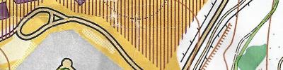
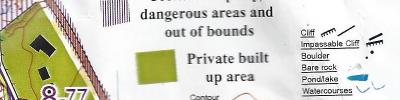
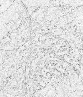
A run on Birds Reef. Having only mapped the terrain 12 months ago, I had a certain navigational advantage, but it didn't show in the results. The car thermometer was showing 29 degrees and I felt it. Pleasing to hear general comments about how people enjoyed the terrain and map. A small poke in the eye for the IOC Mapping Commission. The map is proudly non-compliant with ISOM standards. Its mapped at 1:5,000 and was printed for the event at 1:7,500.


Thursday Apr 14, 2016 #
8 AM
Back, core and achilles 25:00 [1]
9 AM
Running 56:35 [3] 8.7 km (6:30 / km) +160m 5:57 / km
shoes: Kayana White/green
Sparrowhawk run. Decided i had to run rather than walk. Probably no mapping today to rest the foot.
Wednesday Apr 13, 2016 #
8 AM
Back, core and achilles 15:00 [1]
12 PM
Walking 3:00:00 [1] 12.0 km (15:00 / km)
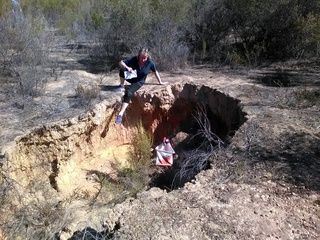
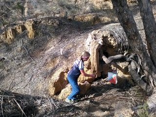
Mapping. A day of unfulfilled promise. Was looking forward to exploring this terrain. The slope map was promising...
Sadly, almost all was unmappable. Mostly a little too small. Three mounds was all I found. The rest will just be brown dots.

Sadly, almost all was unmappable. Mostly a little too small. Three mounds was all I found. The rest will just be brown dots.
Tuesday Apr 12, 2016 #
7 AM
Walking 1:30:00 [1] 6.0 km (15:00 / km)
About 11 holes.
Monday Apr 11, 2016 #
10 AM
Walking 2:00:00 [1] 8.5 km (14:07 / km)
Mapping. Warning. For the first time in my mapping career, I ended up with no idea where I was,so resorted to the safety bearing approach.