Training Log Archive: TheInvisibleLogIn the 7 days ending Dec 18, 2011:
| ||||||||||||||||||||||||||||||||||||||||||||||||||||||||||||||||||
| « | » |
| » now | |||||||||||||||
| Mo | Tu | We | Th | Fr | Sa | Su | ||||||||||||
Sunday Dec 18, 2011 #
Back, core and achilles 10:00 [1]
Running long 1:23:23 [2] 12.0 km (6:57 / km)
shoes: Asics
Even more pleased with this run. Longest distance since late August. Again, ibuprofen, ice, compression and a determination to get through the first 20 minutes. With 2 kilometres to go the knee was certainly in complaint mode, but it was not bad enough to stop me.
The run itself was an attempt to make a much longer version of skraplands. The rules were:
Start and finish at home.
Keep off roads and footpaths as much as possible.
Try and integrate as many gold mining areas as possible.
The result is a pretty interesting run, traversing many areas of mining relics and history withing or on the edge of Bendigo. Included is the next area on my mapping list. Its an comment on the social structure of Bendigo that this terrain is unmapped. Its to the west of town..... like 'wrong side of the Yarra'.
I made many stops along the way to take some pictures for a photo-essay of the run. And to record how wet it was. The forecast was for a wet afternoon., So I ran in the morning. The forecast was wrong.
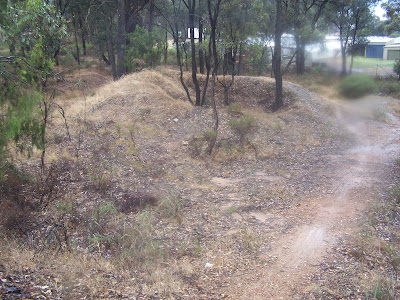
The first evidence of mining is an abandoned area of land two blocks from home. Its quite extensive but bland.
And it was already raining quite heavily.
Some suburbia and then a small mining land reserve off Cohrahe St.
Another short suburban traverse, then the pines and mining sand area off Inglewood Street.
Across Specimen Hill Rd and then into Specimen Hill itself. Small area of mining, but quite detailed.
Then onto the area that Chris has mapped. Not as much mining, but tracks and point features and contours.
Follow the channel through the old closed catchment.
Along the top of the historic bluestone-faced dam.
Round the lake.
Out the fence on the other side. Helps to know where this is.
Past another old mining area.
I would normally follow the abandoned channel, but not today.
Past the old mining dam (I sometimes run around it).
True skraplands on the way off Mining Associates Rd.
Into the next mapping target. This is the original Long Gully.
Along the channel.
Along the wall of the old water supply dam. Its at the head of New Zealand Gully. Bloody kiwis were coming over here even in the 1850s! ;-)
Now into the area burnt on Black Saturday.
Its pouring again as I run through a mining sands area. Don't get a photo to do it justice.
Still pouring past the big mullock heap,
New track through teh really thick regrowth.
Short section of the Long Gully bike path.
Back onto dirt tracks through peppercorns and mullock.
Past Union St Hall. Owned by Govt. Leased now to a community blues group who have it for 10 years at $27 a year. Working bees to make it operational again... as a music venue.
Pouring again as I wend through the mullock and sand heaps burnt in the 2009 fire.
Next target the first of two poppet heads.
Rough track along a rocky ridge.
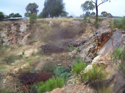
Into the first open cut in the Victoria Hill Reserve.
Next poppet head and I climb this one.
Then into the Bon Accord mining area.
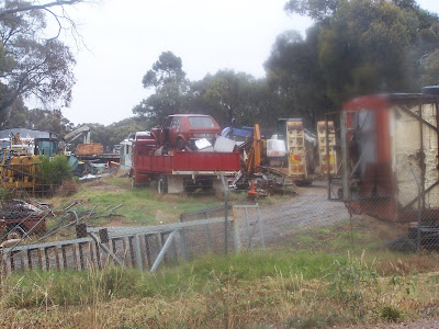
Through the mullock heaps from the New Chum reef workings.
Advance and Adventure mine.
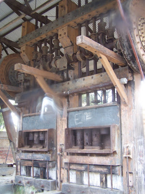
Past the derelict battery.
A view of the next target- Mickey Mouse Hill. Somehow I doubt the name is from the gold mining area.
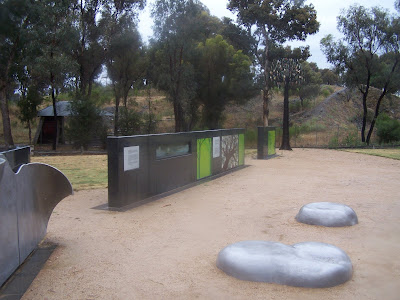
The memorial to the 2009 fire.
Then past the Gold Mines Hotel, now being run for the benefit of the local music scene.
Into the Mickey Mouse Hill diggings.
Narrow path through the wilderness of mullock and feral cotoneaster trees. IT took me quite a few trips to work out how to get through here.
Then a one kilometre downhill run home.
IT has taken a while to piece this together, but it has been worth it! Have to get fit again so I can add more to the circuit across SparrowHawk Road.
The run itself was an attempt to make a much longer version of skraplands. The rules were:
Start and finish at home.
Keep off roads and footpaths as much as possible.
Try and integrate as many gold mining areas as possible.
The result is a pretty interesting run, traversing many areas of mining relics and history withing or on the edge of Bendigo. Included is the next area on my mapping list. Its an comment on the social structure of Bendigo that this terrain is unmapped. Its to the west of town..... like 'wrong side of the Yarra'.
I made many stops along the way to take some pictures for a photo-essay of the run. And to record how wet it was. The forecast was for a wet afternoon., So I ran in the morning. The forecast was wrong.
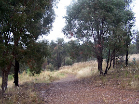
The first evidence of mining is an abandoned area of land two blocks from home. Its quite extensive but bland.
 |
| From Skraplands extended |
And it was already raining quite heavily.
 |
| From Skraplands extended |
Some suburbia and then a small mining land reserve off Cohrahe St.
 |
| From Skraplands extended |
Another short suburban traverse, then the pines and mining sand area off Inglewood Street.
 |
| From Skraplands extended |
 |
| From Skraplands extended |
Across Specimen Hill Rd and then into Specimen Hill itself. Small area of mining, but quite detailed.
 |
| From Skraplands extended |
 |
| From Skraplands extended |
Then onto the area that Chris has mapped. Not as much mining, but tracks and point features and contours.
 |
| From Skraplands extended |
Follow the channel through the old closed catchment.
 |
| From Skraplands extended |
Along the top of the historic bluestone-faced dam.
 |
| From Skraplands extended |
Round the lake.
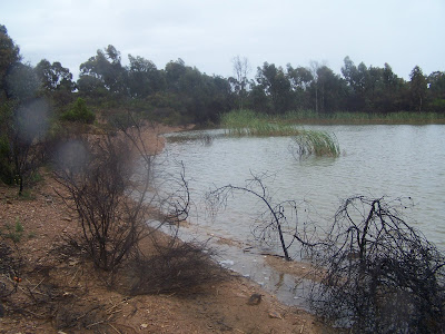 |
| From Skraplands extended |
Out the fence on the other side. Helps to know where this is.
 |
| From Skraplands extended |
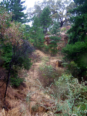
Past another old mining area.
 |
| From Skraplands extended |
I would normally follow the abandoned channel, but not today.
 |
| From Skraplands extended |
Past the old mining dam (I sometimes run around it).
 |
| From Skraplands extended |
True skraplands on the way off Mining Associates Rd.
 |
| From Skraplands extended |
Into the next mapping target. This is the original Long Gully.
 |
| From Skraplands extended |
Along the channel.
 |
| From Skraplands extended |
Along the wall of the old water supply dam. Its at the head of New Zealand Gully. Bloody kiwis were coming over here even in the 1850s! ;-)
 |
| From Skraplands extended |
Now into the area burnt on Black Saturday.
 |
| From Skraplands extended |
Its pouring again as I run through a mining sands area. Don't get a photo to do it justice.
 |
| From Skraplands extended |
Still pouring past the big mullock heap,
 |
| From Skraplands extended |
New track through teh really thick regrowth.
 |
| From Skraplands extended |
Short section of the Long Gully bike path.
 |
| From Skraplands extended |
Back onto dirt tracks through peppercorns and mullock.
 |
| From Skraplands extended |
Past Union St Hall. Owned by Govt. Leased now to a community blues group who have it for 10 years at $27 a year. Working bees to make it operational again... as a music venue.
 |
| From Skraplands extended |
Pouring again as I wend through the mullock and sand heaps burnt in the 2009 fire.
 |
| From Skraplands extended |
 |
| From Skraplands extended |
Next target the first of two poppet heads.
 |
| From Skraplands extended |
Rough track along a rocky ridge.
 |
| From Skraplands extended |
Into the first open cut in the Victoria Hill Reserve.
 |
| From Skraplands extended |
Next poppet head and I climb this one.
 |
| From Skraplands extended |
Then into the Bon Accord mining area.
 |
| From Skraplands extended |
Through the mullock heaps from the New Chum reef workings.
 |
| From Skraplands extended |
Advance and Adventure mine.
 |
| From Skraplands extended |
Past the derelict battery.
 |
| From Skraplands extended |
A view of the next target- Mickey Mouse Hill. Somehow I doubt the name is from the gold mining area.
 |
| From Skraplands extended |
The memorial to the 2009 fire.
 |
| From Skraplands extended |
Then past the Gold Mines Hotel, now being run for the benefit of the local music scene.
 |
| From Skraplands extended |
Into the Mickey Mouse Hill diggings.
 |
| From Skraplands extended |
Narrow path through the wilderness of mullock and feral cotoneaster trees. IT took me quite a few trips to work out how to get through here.
 |
| From Skraplands extended |
Then a one kilometre downhill run home.
IT has taken a while to piece this together, but it has been worth it! Have to get fit again so I can add more to the circuit across SparrowHawk Road.
Saturday Dec 17, 2011 #
Running 52:00 [3] 8.0 km (6:30 / km) +140m 5:59 / km
shoes: Asics
Pretty pleased with this run. Armed with the advice of a physio to run when I can, I decided to run through the early pain. The two ibuprofen tablets before the run probably helped as well. And the hours of icing over the past week. And two days rest from running. So I managed 8 ks and didn't feel too bad after the first 15 minutes. Longest run in two months. On a euphoric high, he contemplates 10 kilometres on Sunday. What was that about not mixing endorphins and decisions.
Friday Dec 16, 2011 #
Note
Tried to run this morning in Mildura. Gave up after a few hundred metres. It wasn't going to improve. Went to physio this afternoon. Diagnosis of one of the knees... cartilage. Not what I wanted to hear. Not cartilage in the other, but not sure what else it is either. Will wait till it is more obvious.
MTB (Not O) 24:00 [2]
Commute
Thursday Dec 15, 2011 #
MTB (Not O) 23:00 [2]
Commute
Wednesday Dec 14, 2011 #
MTB (Not O) 10:00 [1]
Running 46:48 [3] 7.46 km (6:16 / km) +50m 6:04 / km
shoes: Asics
Commute to work.
As a sign of the times, for the second time in two days I had to plan my route to pass a pharmacy to allow the purchase of post-run recovery product. Today it was an elastic knee band (XL size) to hold the ice on the knee whilst working. That and the consumption of a tablet of anti-inflammatory drug and we'll see what happened.
As a sign of the times, for the second time in two days I had to plan my route to pass a pharmacy to allow the purchase of post-run recovery product. Today it was an elastic knee band (XL size) to hold the ice on the knee whilst working. That and the consumption of a tablet of anti-inflammatory drug and we'll see what happened.
Back, core and achilles 10:00 [1]
MTB (Not O) 23:30 [2]
Commute home, trying to adhere to a discipline... not going hard. A few lapses, but not many.
Tuesday Dec 13, 2011 #
Back, core and achilles 10:00 [1]
MTB (Not O) 18:55 [3]
Commute to work... followed by ice pack on both knees.
What would be really useful is a velcro strap on device to hold icepacks on knees while I sit on the desk. I think I will have to lean to sew.
Plan to run home this evening. That will be a good test of the new therapeutic strategy.
What would be really useful is a velcro strap on device to hold icepacks on knees while I sit on the desk. I think I will have to lean to sew.
Plan to run home this evening. That will be a good test of the new therapeutic strategy.
Note
You are all full of schadenfreude!. I have only just noticed that whenever my log focuses on the state of my dysfunctional middle-aged body and its preference to not run, I find my name on the Noisy Logs list. When I write positive stories about interesting terrain or trips.. it slips off.
OK, i'd do the same for you. Was it Mr Wilde who mad some comment about one thing worse than being talked about is not being talked about.
OK, i'd do the same for you. Was it Mr Wilde who mad some comment about one thing worse than being talked about is not being talked about.
Running 45:07 [3] 7.54 km (5:59 / km) +50m 5:47 / km
shoes: Asics
Commute home, followed by immediate ice application. I'm getting excited at the early success. Running home tonight commits me to run to work tomorrow morning. Its part of the single car household logistics. That will be a good test of the new regime.
Note
The open letter from the main WOC 2011 mapper to the IOF. Sounds like a ghastly experience.
https://docs.google.com/viewer?a=v&pid=explorer&ch...
https://docs.google.com/viewer?a=v&pid=explorer&ch...
Monday Dec 12, 2011 #
MTB (Not O) 21:15 [2]
The commute. Had a short stop along the way to buy some ice packs. Plan to have one at work permanently. Seems ice after exercise at least reduces symptoms.
C • ice 10
MTB (Not O) 22:15 [4]
Commute home. Hard into a south wind.