Training Log Archive: dbakkerIn the 7 days ending Aug 13, 2017:
| |||||||||||||||||||||||||||||||||||||||||||||||||||||||||||||||||||||||||||||||||||||||||||||||||||||||||
| « | » |
| » now | |||||||||||
| Mo | Tu | We | Th | Fr | Sa | Su | ||||||||
Sunday Aug 13, 2017 #
3 PM
Running 1:25:45 [1] 8.0 km (10:43 / km) +605m 7:47 / km
So I started at the bottom of the silvermine trail (Ignore the line from home... I didn't use my Garmin I was testing using the bluetooth GPS with my phone and a new app), and was planning on GPSing all the trails along the bottom chunk of the mountain, and look at the forest to see if it was worth mapping for a weeknight event.
So the plan was to take the lowest trail on the way out, and then weave my way back filling in all the other trails. Interestingly, I found a trail I had never been on before, so I took it. It traversed (with a slow climb in general) towards the west along Mount Ida, but slowly petered out. So, rather than just turn around, I decided to bushwhack up the mountain until I hit the cutracross road. Turns out, in most places the forest is very nice, but there were a few sections of superthick deadfall.
Hit the road a little west of where I was expecting, never really knew where I was. Ran back along the road, and then down the second east-most silvermine dirt biking trail.
It is so awesome to be able to go running somewhere completely different all the time.
Saturday Aug 12, 2017 #
Strength 1:15:00 [1]
Friday Aug 11, 2017 #
Paddling 50:00 [1]
Out in eagle Bay. Might be my imagination, but I think the smoke cleared slightly today.
Thursday Aug 10, 2017 #
Strength 30:00 [1]
Wednesday Aug 9, 2017 #
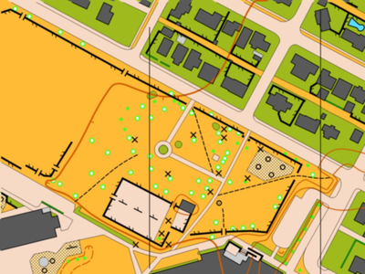
Note
Just finished drafting the Downtown Revelstoke Map. Here is a sample:
Streching/Rolling 12:00 [0]
Bakker know has been a pain lately.
1 PM
Streching/Rolling 10:00 [0]
Tuesday Aug 8, 2017 #
9 AM
Mapping 6:58:03 16.28 km (25:41 / km) +40m 25:22 / km
Fieldwork for the downtown Revelstoke map. This includes the downtown core, a bunch of residential, the rec. centre, Centennial Park, and both the current schools, as well as an old one. Some nice chunks of map, and some pretty boring chunks of map. Unofruntately there is no contour data, so I am having to draw that all by hand... good news is that for the most part it is fairly flat, with most of the elevation changes occuring on one large embankment between the schools and the park.
Smoke wasn't quite as bad in Revelstoke as in Salmon Arm.
Smoke wasn't quite as bad in Revelstoke as in Salmon Arm.
Monday Aug 7, 2017 #
10 AM
Mapping 3:54:44 6.14 km (38:15 / km) +200m 32:54 / km
(sick)
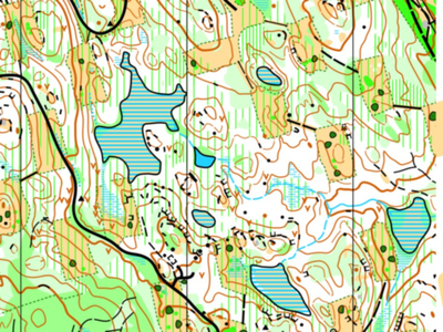
Finishing up the south east corner of the Canoe Creek map. The map is finished! If Sage Stomp is in Salmon Arm next year (waiting on email from Jackie to find out...), then I think we should save the map for then. I think the map is a little too challenging for a weeknight event, so don't really want to use it this fall.
This is the first map that is in ISOM2017 that I have made/seen. Note the vegetation boundary in the green dashes, otherwise not too much is different.
Map sample:
Just about over this cold.
This is the first map that is in ISOM2017 that I have made/seen. Note the vegetation boundary in the green dashes, otherwise not too much is different.
Map sample:
Just about over this cold.
9 PM
Streching/Rolling 10:00 [0]