Training Log Archive: Anna BIn the 7 days ending Apr 29, 2017:
| |||||||||||||||||||||||||||||||||||||||||||||||||||||||||||||||||||||||||||||||
| « | » |
| » now | ||||||||||
| Su | Mo | Tu | We | Th | Fr | Sa | |||||||
Saturday Apr 29, 2017 #
Hike 1:45:00 [3]
hike at the VIC while Elina was riding
Friday Apr 28, 2017 #
Spinning 45:00 [3]
20 minutes of intervals to start it off. 7 x 1 minute hard, 30 seconds very hard, 1 minute off.
Core/strength 15:00 [3]
Thursday Apr 27, 2017 #
Running 35:00 [3]
Note
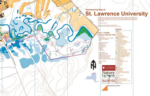
For y'alls that don't know, I work with the GIS department here on campus and we've been working hard on creating a set of orienteering maps for the public to use. These are also the first orienteering maps I've ever made so I'm sure there are mistakes but I'm proud of what I have so far :)
Right now, the physical map itself is set up like a brochure on 11x17 paper where there are explanations/instructions for orienteering on one side and on the other side is the map. It's also a permanent course setup. Below, the top map is the "Advanced" map and it has all the controls that people can go to. We also have a "beginner" version which zooms in a bit more and focuses on the start area and controls near trails. The GIS department (and I) would love some feedback from orienteers!
Side note: The area that was chosen to make the course wouldn't have been my first choice because of the lack of features, but this project was started well before I got on campus to make any other suggestions...so I've been working with what we have. Also, we don't have the best contour data, so again I'm just working with what we have. This is also an ongoing project; more data will be added as it comes in. One example of this is that there's a student currently GPSing ditches and depressions that we don't have data on right now. This will eventually be added and hopefully the map will improve over time.
Check em out!
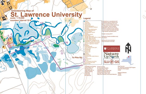
C • Maps 5
Wednesday Apr 26, 2017 #
Spinning 45:00 [3]
Tuesday Apr 25, 2017 #
Running 32:00 [3]
Core/strength 6:00 [3]