Training Log Archive: coadyIn the 31 days ending Jul 31, 2016:
| |||||||||||||||||||||||||||||||||||||||||||||||||||||
| « | » |
| » now | ||||||||||||||||||||||||||||||||||
| Fr | Sa | Su | Mo | Tu | We | Th | Fr | Sa | Su | Mo | Tu | We | Th | Fr | Sa | Su | Mo | Tu | We | Th | Fr | Sa | Su | Mo | Tu | We | Th | Fr | Sa | Su | |||||||
Saturday Jul 30, 2016 #
9 AM
running (Uluru run) 49:13 [3] 10.0 km (4:55 / km)
run around Uluru
rode around it with the family the day before, so didn't need to stop and read all the info, but I did run around in the opposite direction :)
rode around it with the family the day before, so didn't need to stop and read all the info, but I did run around in the opposite direction :)
Saturday Jul 23, 2016 #
Event: World Rogaining Champs 2016
12 PM
Rogaine race (WRC) 23:25:00 [3] 72.0 km (19:31 / km)
slept:0.0
WRC with james
72km estimated using measure tool in PDF
I plotted our course on the map using 3Drerun then added GPS, course length in results is 53.7k, in 3drerun it is 53.6km, distance travelled in 3Drerun is 71km
gps was 56.1km to HH (55.4 using 3drerun)
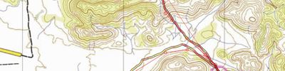
Our plan was to head out E and tackle the high pointers in the spinifex before night then get to the ANC, head to the north to use the trackback to the HH, then grab as many in the SW then NW of HH.
It all started as planned, plenty of company from 73-52-64-102, we left 63 as our emergency backup plan would have taken us from ANC-76-35-63-44-HH, lucky we didn't need this.
Then came the Spinifex (capitalized here as it deserves a little respect) ..
102-91 (2h6m and 10.2k) was straight to get as close to the control before hitting spinifex it seemed the worst stuff was from the top of the hill to 91 (possibly due to lack of traffic or not knowing the best way to avoid it) the higher ground seemed better, the gaitors and taped up shoes kept most of it out but our knees got hammered in some sections.
91-112 we were very slow and didn't see many others, I think others may have gone via 72, we were planning to visit this on the way back. At a more careful (slow and sometimes a bit of zig-zag) speed the spinifex didn't bother us as much, keeping to the highest ridges seemed to be a good (but slow) plan.
112-82 (3h50m and 14.4k) we were still in slow - avoid spinifex mode.
We originally planned to go to 116 but I didn't like the climb (spinifex + steep climb was the worst) so we decided to grab this from the river on our way N after the ANC.
82-84-76-ANC (5h20m and 19k) we hit the ANC which was a little earlier than planned (6pm), but we skipped 116 and picked up 76 on the way, since I had just run out of water, it was excellent timing and knowing we have passed most of the bad spinifex was a nice thought. We had a 25 minute break for a burger, cake, milo and to refill of our water.
ANC-94-107 (7hr 24k) since we were a little early and out of spinifex avoid mode, we added 94 and 107 to our initial plan. 94 was a highlight going through a nice gorge, so nice we decided to go back the same way ! (and avoid a strip of spinifex) we had to light up after leaving the track to 107 which was one of the harder (steep+spinifex+loose rock) climbs we had to do.
107-57-116-88-51 (9h50m 32k) our plan to follow the river for a handrail during the darker period of night time went well, it also helped to minimise climb and spinifex. moonrise was expected after 10pm, some cattle tracks to 57 and along the river also helped as the river was too sandy to walk fast.
51-108 we started to have some nav wobbles … a few hesitations on the way to 108, the GPS shows we went where we wanted to go, but the last 300m to the control didn’t feel 100% right. I still call this a Nav err #1
We wanted to get to the HH between 12 and 18 hrs, expected time 3am, at 10h30m we decided not to add 89 and 117 as this could get us there too late, and there were plenty near the HH to get in the morning if we had time.
108-48 hit the watercourse and followed this to the top of the hill, then down and up to the narrow spur … Nav err#2 .. after a couple of minutes we realised that we were 1 spur to early and on top of a green spinifex knoll rather than the tiny knoll 150m further on. I’ll note here that other teams seemed to be having issues here ... perhaps it was contagious…
48-97 (11h58m 36.2km at 97) got ½ way and hit the 3 creek junction, but decided the creeks were getting hard to nav at night with taller trees so changed plan from following the creek and crossed the spinifex knoll, the spinifex however didn’t bother us any more, sometimes you get the odd poke in the knee, but this is what normal orienteering in scrubby areas is like. Somehow managed Nav error #3 by turning NW on the ridge rather than SW, but noticed and changed plan again and went back down the watercourse.
97-101 3 nav errors and all in the last 3 controls, felt better that we were out of the hard nav and had a rather easy ride home, but since it was midnight and a minimum of 12 km back to the house we knew it would probably be later than planned (3am) but with a few extra (94,107) we were happy with our progress, we did decide to get all the larger 60 or more pointers and skip the smaller ones. So we took the easy nav across the river to the track and Nav error #4 appeared when we missed the track … so 4 nav errors in 4 controls grrr … all were small errors which were picked up quickly but they were still annoying!
101-72 the track we missed was sometimes obvious but other times very faint, at one stage we lost it and had to spend a minute searching for where it went! So when leaving it to follow the rivers we made sure we had an obvious feature to spot on the way back, and other teams made various sculptures from rocks and sticks for this same reason!
72-71 another nav error, unable to backtrack we hit the river and guessed the junction was NW but we were wrong … losing 7 minutes …
71-62 trying to be careful, but taking a shortcut we hit the saddle in the circle, then contoured to the watercourse, but no flag, tried the next and the next, up and down … relocated, eventually found the trail from previous teams taking us to the control. This error was the worst costing us 15-20 mins
6 minor nav errors in 7 controls between 10pm and 5am
WaterStop (16h54m 52.9k) since I had been out of water for about 40 mins it was nice to have a quick (6min) refill, milo and cake
62-81-HH (17h 57m 56.1k) craving for a bacon an egg roll for breakfast but all the bacon had been sent to the ANC !?!? arrrgghhhh .. had to settle for a sausage and egg roll .. spirits started to drop and I struggled to function for the next 50 minutes … somehow managed to refill water but did my body wanted sleep. Plan was to go out just before sunrise for the last loop, SW and as much NW as we could do .. sleep almost took over but just managed to fight it and motivated myself to get going, hoping the sun would inspire me later.
HH-80-50 managed to walk, sometimes in a semi zombie state but was feeling better after hitting 80 and seeing the sun. very glad we came out here as the terrain was spectacular, nothing I had ever seen before!
50-100-40-70 kept a steady pace and careful nav, so much easier in the day time! Managed to misjudge 70 by going around the bottom, we both thought the top of the ridge was too high, but alas, after a bit of climbing a very steep and almost dangerous hill we found the control on top!
70-31-61-30-HH (71-72km) not much to report, we had plenty of time up our sleeve mainly flat walking with obvious features so nav was simple. We didn’t want to take any extra controls and risk having to run at the end, took a leisurely walk and got home with about 35 minutes to spare!
Managed to get by with no blisters, some sores from rubbing that had broken the skin, just above the tape that kept the blisters away, but not blisters as such.
Pretty much hit our planned route, with perfect nav probably would have picked up another 2-5 controls near the HH, but our main goal was to spend most of the 24 hrs out there and not bail. We possibly could have ran more, but this may have prevented us from staying out for the full 24hrs ... so overall we were very pleased with our result!!. My first 4th 24hr rogaine but my first with no sleep!
72km estimated using measure tool in PDF
I plotted our course on the map using 3Drerun then added GPS, course length in results is 53.7k, in 3drerun it is 53.6km, distance travelled in 3Drerun is 71km
gps was 56.1km to HH (55.4 using 3drerun)
Our plan was to head out E and tackle the high pointers in the spinifex before night then get to the ANC, head to the north to use the trackback to the HH, then grab as many in the SW then NW of HH.
It all started as planned, plenty of company from 73-52-64-102, we left 63 as our emergency backup plan would have taken us from ANC-76-35-63-44-HH, lucky we didn't need this.
Then came the Spinifex (capitalized here as it deserves a little respect) ..
102-91 (2h6m and 10.2k) was straight to get as close to the control before hitting spinifex it seemed the worst stuff was from the top of the hill to 91 (possibly due to lack of traffic or not knowing the best way to avoid it) the higher ground seemed better, the gaitors and taped up shoes kept most of it out but our knees got hammered in some sections.
91-112 we were very slow and didn't see many others, I think others may have gone via 72, we were planning to visit this on the way back. At a more careful (slow and sometimes a bit of zig-zag) speed the spinifex didn't bother us as much, keeping to the highest ridges seemed to be a good (but slow) plan.
112-82 (3h50m and 14.4k) we were still in slow - avoid spinifex mode.
We originally planned to go to 116 but I didn't like the climb (spinifex + steep climb was the worst) so we decided to grab this from the river on our way N after the ANC.
82-84-76-ANC (5h20m and 19k) we hit the ANC which was a little earlier than planned (6pm), but we skipped 116 and picked up 76 on the way, since I had just run out of water, it was excellent timing and knowing we have passed most of the bad spinifex was a nice thought. We had a 25 minute break for a burger, cake, milo and to refill of our water.
ANC-94-107 (7hr 24k) since we were a little early and out of spinifex avoid mode, we added 94 and 107 to our initial plan. 94 was a highlight going through a nice gorge, so nice we decided to go back the same way ! (and avoid a strip of spinifex) we had to light up after leaving the track to 107 which was one of the harder (steep+spinifex+loose rock) climbs we had to do.
107-57-116-88-51 (9h50m 32k) our plan to follow the river for a handrail during the darker period of night time went well, it also helped to minimise climb and spinifex. moonrise was expected after 10pm, some cattle tracks to 57 and along the river also helped as the river was too sandy to walk fast.
51-108 we started to have some nav wobbles … a few hesitations on the way to 108, the GPS shows we went where we wanted to go, but the last 300m to the control didn’t feel 100% right. I still call this a Nav err #1
We wanted to get to the HH between 12 and 18 hrs, expected time 3am, at 10h30m we decided not to add 89 and 117 as this could get us there too late, and there were plenty near the HH to get in the morning if we had time.
108-48 hit the watercourse and followed this to the top of the hill, then down and up to the narrow spur … Nav err#2 .. after a couple of minutes we realised that we were 1 spur to early and on top of a green spinifex knoll rather than the tiny knoll 150m further on. I’ll note here that other teams seemed to be having issues here ... perhaps it was contagious…
48-97 (11h58m 36.2km at 97) got ½ way and hit the 3 creek junction, but decided the creeks were getting hard to nav at night with taller trees so changed plan from following the creek and crossed the spinifex knoll, the spinifex however didn’t bother us any more, sometimes you get the odd poke in the knee, but this is what normal orienteering in scrubby areas is like. Somehow managed Nav error #3 by turning NW on the ridge rather than SW, but noticed and changed plan again and went back down the watercourse.
97-101 3 nav errors and all in the last 3 controls, felt better that we were out of the hard nav and had a rather easy ride home, but since it was midnight and a minimum of 12 km back to the house we knew it would probably be later than planned (3am) but with a few extra (94,107) we were happy with our progress, we did decide to get all the larger 60 or more pointers and skip the smaller ones. So we took the easy nav across the river to the track and Nav error #4 appeared when we missed the track … so 4 nav errors in 4 controls grrr … all were small errors which were picked up quickly but they were still annoying!
101-72 the track we missed was sometimes obvious but other times very faint, at one stage we lost it and had to spend a minute searching for where it went! So when leaving it to follow the rivers we made sure we had an obvious feature to spot on the way back, and other teams made various sculptures from rocks and sticks for this same reason!
72-71 another nav error, unable to backtrack we hit the river and guessed the junction was NW but we were wrong … losing 7 minutes …
71-62 trying to be careful, but taking a shortcut we hit the saddle in the circle, then contoured to the watercourse, but no flag, tried the next and the next, up and down … relocated, eventually found the trail from previous teams taking us to the control. This error was the worst costing us 15-20 mins
6 minor nav errors in 7 controls between 10pm and 5am
WaterStop (16h54m 52.9k) since I had been out of water for about 40 mins it was nice to have a quick (6min) refill, milo and cake
62-81-HH (17h 57m 56.1k) craving for a bacon an egg roll for breakfast but all the bacon had been sent to the ANC !?!? arrrgghhhh .. had to settle for a sausage and egg roll .. spirits started to drop and I struggled to function for the next 50 minutes … somehow managed to refill water but did my body wanted sleep. Plan was to go out just before sunrise for the last loop, SW and as much NW as we could do .. sleep almost took over but just managed to fight it and motivated myself to get going, hoping the sun would inspire me later.
HH-80-50 managed to walk, sometimes in a semi zombie state but was feeling better after hitting 80 and seeing the sun. very glad we came out here as the terrain was spectacular, nothing I had ever seen before!
50-100-40-70 kept a steady pace and careful nav, so much easier in the day time! Managed to misjudge 70 by going around the bottom, we both thought the top of the ridge was too high, but alas, after a bit of climbing a very steep and almost dangerous hill we found the control on top!
70-31-61-30-HH (71-72km) not much to report, we had plenty of time up our sleeve mainly flat walking with obvious features so nav was simple. We didn’t want to take any extra controls and risk having to run at the end, took a leisurely walk and got home with about 35 minutes to spare!
Managed to get by with no blisters, some sores from rubbing that had broken the skin, just above the tape that kept the blisters away, but not blisters as such.
Pretty much hit our planned route, with perfect nav probably would have picked up another 2-5 controls near the HH, but our main goal was to spend most of the 24 hrs out there and not bail. We possibly could have ran more, but this may have prevented us from staying out for the full 24hrs ... so overall we were very pleased with our result!!. My first 4th 24hr rogaine but my first with no sleep!