Discussion: sprint tunnel mapping
in: Orienteering; General
Apr 14, 2014 9:01 AM
#
Is this the approved way to map a tunnel, http://news.worldofo.com/wp-content/uploads/2014/0...
with a gap in the uncrossable wall? I thought the wall, in general, was supposed to remain solid with a crossing point symbol used.
Or if they only want to map the "main running level", maybe make the tunnel walls solid black.
I understand what the mapper is doing, and sitting down looking at the map it makes a lot of sense... but...
Apr 14, 2014 9:17 AM
#
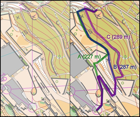
I can see an Option D in there that is potentially shorter than all three routes shown. Does that make me a good orienteer?
Apr 14, 2014 9:50 AM
#
Only if Option D works on the ground as well as in theory - which it probably doesn't.
It makes you good at Catching Features...
It makes you good at Catching Features...
Apr 14, 2014 1:04 PM
#
This is where I've started using the bridge symbol to show entrances to tunnels. It shows that you can cross under it like a bridge but also shows that you can't cross from the upper level to the outside.
I know it's not strictly ISSOM but it seems to me to be a sensible extension of the symbol.
I know it's not strictly ISSOM but it seems to me to be a sensible extension of the symbol.
Apr 14, 2014 1:38 PM
#
You're right. I had another look at Option D and I think it fails due to the aforementioned mapping of the runnable level.
Apr 14, 2014 1:51 PM
#
ISSOM
518.1 Underpass or tunnel
If underpasses or tunnels etc. are to be used in a competition, they shall be
emphasized with the symbol crossing point(708) or crossing section (708.1)
518.1 Underpass or tunnel
If underpasses or tunnels etc. are to be used in a competition, they shall be
emphasized with the symbol crossing point(708) or crossing section (708.1)
Apr 14, 2014 2:01 PM
#
The fact that ^that is ignored so often makes me feel like course planners are trying to make sprint an eyesight competition rather than an orienteering one.
Apr 14, 2014 7:13 PM
#
I think tRicky just demonstrated why this is not a good way of mapping the tunnel.
Apr 14, 2014 10:52 PM
#
They ran the other way through the tunnel earlier in he course, so they knew what to expect. I think the only fair way to map it for this routechoice is as an underpass (grey = main running level) with the level above (not used on any sane route choice) out of bounds.
This discussion thread is closed.