Discussion: Mapping the North Pole! Canada to claim it?
in: Orienteering; General
Dec 2, 2013 12:03 AM
#
H"O" H"O" H"O"
Later this week Canada may claim the North Pole:
http://www.theglobeandmail.com/news/national/canad...
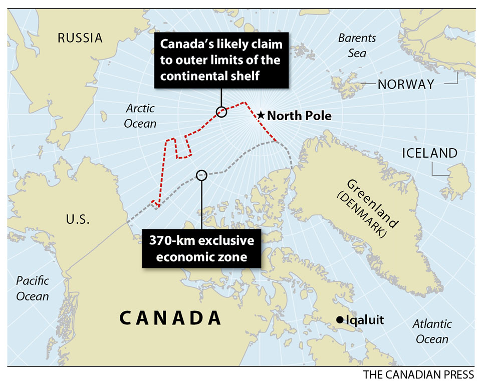
Potential Canadian claim map:
http://cponline.thecanadianpress.com/graphics/2013...
Later this week Canada may claim the North Pole:
http://www.theglobeandmail.com/news/national/canad...
Potential Canadian claim map:
http://cponline.thecanadianpress.com/graphics/2013...
Dec 2, 2013 1:45 AM
#
So, not claiming the pole itself, but claiming area that's north of Russia.
Dec 2, 2013 4:31 AM
#
Oh, so you've seen tRicky swimming? Yes, he does have a snorkel because otherwise he drowns. :D
Dec 2, 2013 5:10 AM
#
No, they aren't claiming the ice, they're claiming the sea floor. (Which is where Santa's castle is, under a huge dome.)
Dec 2, 2013 5:16 AM
#
tRicky, it's not the North Pole that moves, but the magnetic North Pole, which has been moving within Canada for a long time.
While you're up north with your snorkel, there's lots of mapping work to be done:
"“It would seem prudent, for both shipping safety and economic efficiency reasons, for the Canadian government to obtain a complete set of the Soviet charts so as to determine their potential utility. It might also be possible to obtain the Soviet equivalent of field sheets and an effort to do so should certainly be made.”
Although Canada is improving its knowledge of the northern oceans, most of that mapping involves High Arctic waters in preparation for an extended continental shelf claim under the United Nations Convention of the Law of the Sea. Sea lanes within the Arctic islands are getting less attention.
“At the current rate of charting, it will take 300 years for the Canadian Hydrographic Service to bring all our charts for the Canadian archipelago to world standards,” Mr. Byers said.
He points out three ships ran aground in the Arctic last summer.
“Those three groundings focused attention on the inadequacy of our charts. That’s where the Soviet charts are most interesting."
http://www.theglobeandmail.com/news/national/russi...
Dec 2, 2013 6:19 AM
#
I interpreted tRicky's comment as saying the ice (and therefore flag) would move relative to the stationary (true) north pole.
Dec 2, 2013 2:01 PM
#
The true north pole (i.e. the intersection of the earth's axis of rotation and the surface) moves by a few meters per year.
Dec 3, 2013 10:30 AM
#
I would pick American charts of the Russian and Canadian Arctic over Soviet charts any day. While you are at it you could probably count more on US government maps of everything from the Kremlin to Cairo to the sleeping habits of every major politician in Europe.
Dec 4, 2013 1:06 PM
#
So after all of Canada's mapping and research apparently our claim isn't good enough for our Prime Minister because the claim did not include the North Pole. Either that or he is trying to deflect media attention away from scandal after scandal.
http://www.theglobeandmail.com/news/politics/harpe...
http://www.theglobeandmail.com/news/politics/harpe...
Dec 5, 2013 1:04 AM
#
Under the UN Convention on the Law of the Sea
I thought the Old Man of the Sea governed all laws in his domain?
I thought the Old Man of the Sea governed all laws in his domain?
Dec 5, 2013 6:10 AM
#
GuyO:
...he is trying to deflect media attention away from scandal after scandal.
Rob Ford was not enough of a deflection, eh?
Rob Ford was not enough of a deflection, eh?
Dec 5, 2013 2:53 PM
#
A further update:
http://www.theglobeandmail.com/news/politics/turf-...
If the Lomonosov Ridge is shown to extend to all three of Canada, Russia and Denmark (Greenland) as well as the North Pole, that would seem to constitute the scientific basis for all three to claim the North Pole. From the first article:
"Rob Huebert, an Arctic expert at the University of Calgary, will be watching to see if Canada stretches its claim past the North Pole. The geologic justification – an undersea mountain range called the Lomonosov Ridge that stretches north from Ellesmere Island – is there, he said."
Then how much of the Lomonosov Ridge to claim then does become a political decision for all three countries and, to the extent the claims overlap, they can then negotiate or ask the International Court of Justice for a resolution. The ultimate result could well be that the territories of all three extend to the North Pole, with the North Pole itself becoming a boundary point.
When the Law of the Sea was being negotiated 30-40 years ago, I doubt it was contemplated that any continental shelf extended from one side of any ocean to the other side, although it sounds as though the Soviets could have been aware of the possibility as a result of their secret mapping of the Arctic seabed by submarine.
The bigger legal dispute over the Arctic for Canada as the ice melts could be over the Canadian claim that the Northwest Passage (officially called the Canadian Northwest Passage in Canada) is an inland Canadian waterway, whereas other countries (in particular, the US) consider it to be an international waterway.
Dec 11, 2013 5:50 AM
#
Perhaps Russia and Canada can settle the dispute with a hockey game. Winner gets the north pole.
http://www.slate.com/blogs/the_world_/2013/12/10/a...
http://www.slate.com/blogs/the_world_/2013/12/10/a...
This discussion thread is closed.