Discussion: Ideas for event organizers
in: Orienteering; General
Jul 27, 2013 6:27 AM
#
barb:
What great techniques have you seen this summer in Europe or elsewhere for organizing events?
Here's one I like: at the Croatian Open, all changes after a certain date cost 2 euros. At the event site, you fill out a simple form (name, club, and choice of changes such as class change, time change), and pay the money. The form goes off to someone else who decides whether the change can be accommodated, and implements it. You come back later (~15 minutes) to see whether your request was successful.
Charging for changes should encourage competitors to doublecheck that they are correctly and conveniently entered ahead of time - and/or, it raises more money for the club. Filling out the paper request means that the requests can be accommodated somewhat offline so more people can be processed.
Jul 27, 2013 8:17 AM
#
At the Oringen, all youth classes 16 and under could look at their map for the minute before they start...so when they got to the last call up line. I thought that was a good idea.
Jul 27, 2013 9:51 AM
#
Today a first for Bendigo local events... entry via SI stick dip and a single page on a tablet.
Jul 27, 2013 8:08 PM
#
barb:
I love the happy/sad faces on the beginner, W10 and M10 course. In fact, I ran that course yesterday, map-free, looking for Mom.
Jul 27, 2013 8:37 PM
#
I like the events where there is a specific class for F/M-10 shadowed.
Jul 28, 2013 2:18 PM
#
this was in Finland but several years ago, I was told that the sting course would take some round-a-bout route while a more direct route was available off string. The idea was that the kids that chose and successfully did the off string route were rewarded with a faster time. I should note that the string course there seemed quite long and appeared more geared toward the young white runner than a toddler.
Jul 28, 2013 2:32 PM
#
Jul 27, 2013 8:59 AM# Delyn:
O-Lynx Touch is what TheInvisibleLog is referring to I believe.
That is correct. I have had the privilege of test driving the O-Lynx Touch as well, and it is a great enhancement to OE. QOC plans to use it at their events when the season starts up in September.
O-Lynx Touch is what TheInvisibleLog is referring to I believe.
That is correct. I have had the privilege of test driving the O-Lynx Touch as well, and it is a great enhancement to OE. QOC plans to use it at their events when the season starts up in September.
Jul 28, 2013 4:05 PM
#
Haha!
What I wrote elsewhere on July 23:
Idea: get a cheap tablet (or tablets, if your club is bigger), and have an app that people can use to register, sign waivers, and check boxes for club/national memberships. Heck, you can even hook up those little card swiper thingies and have people register and pay. The app would keep track of all the stuff electronically so you don't have to. Just hire someone to write the app and have it available to all O-USA clubs.
And then in this thread on July 27:
O-Lynx Touch!
Fantastic! It's already done!
Jul 28, 2013 4:29 PM
#
- the fold-up event info pocket guide at the Scottish 6-Days, the idea for which I believe they got from Adrian, who I believe got it from somewhere else in Europe. :-)
- allowing M/F-10s to look over their course and talk it over with their parents before heading out (for as long as they like)
- saying "sorry, no water, bring your own" (this wouldn't be okay everywhere, but providing water for 3000 competitors when it can be obtained by all for free from their accommodations...)
Jul 28, 2013 8:10 PM
#
Pink Socks wrote: Haha!
What I wrote elsewhere on July 23:
Idea: get a cheap tablet (or tablets, if your club is bigger), and have an app that people can use to register, sign waivers, and check boxes for club/national memberships. Heck, you can even hook up those little card swiper thingies and have people register and pay. The app would keep track of all the stuff electronically so you don't have to. Just hire someone to write the app and have it available to all O-USA clubs.
And then in this thread on July 27:
O-Lynx Touch!
Fantastic! It's already done.
Yes, Touch is nicely done to work wilth OE2010, my prefered software. But, can you imagine how many variations of this front end application would have to be written to work with all of the different scoring software clubs want to use? I can think of at least 10 different software applications used in the US.
Jul 29, 2013 1:50 AM
#
Toph:
I organised the recent event here in bendigo that invisiblelog is mentioning. And from the experience of that I found that if you using OE and running a enter on the day system then I think that O-lynx touch is the way to go. It is so simple and can be set up within a couple of minutes and just works.
I only found out about the program a week before the event, before that I was going to use the registration through OE direct entries system. Anyway at that time I had no access to a windows touch device, and I only had a couple of days to sort things out before I had to go away for work.
We ended up buying the club a Asus vivotab smart and a micro usb to full size usb adapter. I spent about a half a day(slow internet) doing all the windows updates and learning how to use windows 8 (mac user). and then after that I spend probably 10 minutes sorting out how to use the program it was that simple. very intuative as I did not have any instruction manual to work from and it didn't take long to work out at all.
anyway if you are interested. Phillip Herries, the creator from O-lynx in NZ has now put a link to a trial download on his blog
Jul 29, 2013 2:06 AM
#
Toph. I think this is the only way to run the Ironman at the end of the month.
Jul 30, 2013 9:34 AM
#
GuyO:
Re: O Lynx: If there is only one tablet used, I could see very long registration lines; with paper registration forms, at least people can fill them out before or while waiting to hand them in and pay.
@Barb: From my experience as a registrar, late changes are a mild annoyance, but, IMO, part of the "cost of doing business", for which I would not want to "nickel-and-dime" our customers. I'll add though, that if organizers feel they need to discourage changes by using fees -- nominal or otherwise -- that the fees should only kick in at least 2-3 days after course info (length, climb) is posted.
@Barb: From my experience as a registrar, late changes are a mild annoyance, but, IMO, part of the "cost of doing business", for which I would not want to "nickel-and-dime" our customers. I'll add though, that if organizers feel they need to discourage changes by using fees -- nominal or otherwise -- that the fees should only kick in at least 2-3 days after course info (length, climb) is posted.
Jul 30, 2013 10:58 AM
#
It takes about 5 seconds to drop the stick in the box and then point at the preferred course. Payment is self-service and we have between 60 and 100 people each Saturday. Once you start handling cash at events, then you have lines of people. For larger and more serious events entry will be on-line and there is no need for registration via a tablet anyway. Its a particular event niche.
Jul 30, 2013 11:27 AM
#
I was wondering about entry speed also and in-particular of the street-o scenario, where you have a relatively large number of newcomers not in the system already. Currently in Brisbane time efficiency is achieved by having new competitors fill out a paper form and then getting a volunteer to enter them in the computer during the race; the tablet would force entries to be done linearly so may not be the best fit for this type of event.
Jul 30, 2013 11:55 AM
#
Get the volunteer to use the tablet ;) but seriously, think glass half full, not half empty. O-Lynx Touch makes the job so easy, embrass the idea
Jul 30, 2013 12:28 PM
#
For me, Touch is about complementing the OE2013 computer, not replacing it. QOC has from 100-225 race day entries processed at a local event. Lots of these are newbies and/or groups. Everyone stands in one line to pay and sign waiver, and then goes to the computer line to get entered on a course.
Touch will be geared towards QOC members with their own SI-cards, not the newcomers. An Express line of sorts, replacing the two lines. Sign waiver, pay $5, put SI-card in Touch, select course, enjoy course. The waiver book can be passed back down the line as people are waiting.
Hopefully, the Express system will encourage membership and SI-card ownership.
Jul 30, 2013 1:32 PM
#
Bend over backward late registrations - with a price.
This was introduced to me in the course of CCOF 2011, and the concept is simple enough - replace the "no late registration" rule with a "very late registration cost".
Sure - we know about early registrations - offer a discount and get competitors to commit early (makes the organizers feel comfortable, helps in promoting and sponsorship, etc) Cal this 70% of X, a 30% discount.
Then there's the regular deadline - you know - the one you want people to register by. This might be X - "full price".
And then there's usually a "late period". It's after the comfortable registration, but still in time for you to do the things like print maps and fit the competitor into the start schedule. This is often 150% of X - a 50% penalty.
But after the end of that deadline, there's a "no more registrations" statement.
That is regularly trounced...
- "My plans changed last minute, and I'm 50 miles away, can't you find me a starting position?"
- "I can't believe I just found out about the event. I need to get a good tuneup in before heading to Europe."
- "Won't you make an exception for me? PLEASE?"
And by the rules setup, you can make an exception, but all you can do is have them pay the late registration fee - and that hardly accounts for the effort.
So - create a "Very Late Registration" time period that covers from the end of late registration to an hour before start times. This registration costs a lot - to cover the organizers last minute efforts. And I mean a lot...
If registration is normally $40 with early $32, and late $60, very late registration is $140.
Remember - this is instead of saying _no registrations past this date_
The intent is that this is a last resort for anyone - and you'd actually prefer not to offer it.
But when someone comes up the night before the race and says "Hey - I brought along Bob, and even though registration was closed a week ago, can you give Bob a start time?", you don't have to feel bad about saying "no, sorry", or feel bad about doing it and grumbling the whole time...
You say: "Certainly - have Bob fill out this form, and give us $140, and we'll be happy to find a starting time for him."
And since this was advertised (when you put up your event information 4 months ago), there should be no surprise. You told everyone that coming very late WAS possible, but that it had a steep price.
Now the decision to pay or not pay is Bob's, and you can feel happy either way.
I did not understand the full impact of this process at the time, but have come to realize how useful it is...
Jul 30, 2013 1:58 PM
#
Based on our experience, about half of Bobs turn around. I think it's still OK; the goal is not necessarily to accommodate all Bobs.
Jul 30, 2013 9:19 PM
#
Extending that a bit more how about the airline pricing model. Limited numbers of very cheap "seats", normal prices for a while, as the event approaches the price appears to go up or down depending on whether there are seats needing to be filled. I guess they have specialists skilled in getting the maximum income from each flight, does anyone know?
Jul 30, 2013 10:45 PM
#
@Uncle JiM, I think it's a great idea. It will help to move local orienteering events towards a Parkrun-like simplicity, and I think that is needed for both participants, especially new ones, and organisers.
Jul 31, 2013 1:09 PM
#
GuyO:
So much emphasis on gouging, screwing, etc. other orienteers ("Bob"). Sad.
Jul 31, 2013 1:12 PM
#
If Bob was more considerate and planned his life better, this wouldn't be an issue.
Jul 31, 2013 1:57 PM
#
Surely there shouldn't be any "cheap seats", the first entry prices should be how much it is costing to run the event (costs, taxes, desired profit marigin etc). Everything after the deadline should have a late fee. Late entrants should not be used to subsidise early birds' cheaper prices.
Set a deadline for this that YOU are happy with as the organiser. There was a thread on Nopesport where British organisers were complaining about people entering just before the dead-line. Obviously forgetting that they set the dead-line, and if they wanted people to enter earlier then they should have made their dead-line earlier...
The bigger the event the more strict the entry secretary should be. But for a sport suffering with participation, I would always try an accommodate Bob if I could. Unlike Mr Wonderful, I understand that not everything in life can be planned for, and some people don't have the money to pre-enter an event they are likely not to participate in due to work, or health or any other reasons. Not everything in life is controllable.
Jul 31, 2013 3:07 PM
#
I plan poorly all the time. I'm used to paying for it in one way or another, whether it is weekend repair rates for the furnace or not getting a table on Valdntine's Day without a reservation. I guess the repair folks and restaurants are screwing me over?
Jul 31, 2013 8:38 PM
#
I originally felt as Guy did - that it was taking advantage of the poor planner.
Until we held the event.
You know what "No ability to register after this date" means to some people?-)
And that's why I am quite up front about the setup - it isn't just a later fee, it's a "We put numbers in for dinner, t-shirts, scheduled the runners, and have everything ready to go" disruption to accommodate the very late individual.
The alternative is to say "no, you can't register"
Plane tickets - they have a different type of demand, I don't know that we could use that. Do we have any economists online;-)
Aug 1, 2013 2:13 AM
#
Just tell people they cannot win the championship if they do not pre-enter.
Aug 2, 2013 2:42 PM
#
The problem is in part that because of Bob's lack of timeliness, the experience is altered not in a good way for timely participants. The optimization goal should be the quality of the experience for the latter. What Bob may feel is secondary.
Aug 2, 2013 4:11 PM
#
Gil:
The problem is in part that because of Bob's lack of timeliness, the experience is altered not in a good way for timely participants
I have seen this happen many times. I quit rec basketball league after 3+ years of participating because too much emphases was not to discriminate against Bobs and league did not have any provisions dealing with Bobs. There were occasional Bobs during first 3 years when I participated including myself and most organization can handle one or two occasional Bobs without impacting others. But then all in sudden too many Bobs started to come. After while it became too disruptive when Bobs started to came, asked to stop games, re-shuffle teams, restart games, if you did not they would sit on side-lines and complain that they paid money and they should be able to play. I was no longer enjoying it and I quit. I heard that league folder about month or so after that.
Rules and regulations are in place not necessary to screw someone but to encourage good behavior and discourage bad behavior. There is no way to eliminate Bobs completely but it's good and necessary to have provisions for Bobs.
Aug 3, 2013 2:06 AM
#
We have a club score tomorrow so just a note that the O-Lynx Touch download has been refreshed to also be compatible with OEScore2003 as well. Just a club event so Bobs welcome.
Aug 3, 2013 2:27 AM
#
Darn it! My name is Patrick. But I'm busy anyway, my club has a score-o tomorrow, too!
Aug 3, 2013 3:35 AM
#
Bob's bad behaviour?? Come on!!
We had a Bob recently come to a State (Night) Championship. Bob was well qualified because he'd come back first on a Jukola night leg a couple of months prior. Unfortunately he was told he couldn't run because he hadn't pre-entered. Why? Well, actually an Icelandic volcano had erupted that week and his flight was cancelled. Silly Bob, Poor Bob, not Bad Bob.
We had a Bob recently come to a State (Night) Championship. Bob was well qualified because he'd come back first on a Jukola night leg a couple of months prior. Unfortunately he was told he couldn't run because he hadn't pre-entered. Why? Well, actually an Icelandic volcano had erupted that week and his flight was cancelled. Silly Bob, Poor Bob, not Bad Bob.
Aug 3, 2013 5:55 AM
#
Gil:
@O-ing: There are different reasons why someone becomes Bob but in this context and I was implying most common reasons why someone does not pre-register for an event - laziness or ignorance or absent mindedness. If you don't like terminology I used substitute bad with undesirable. I was using figurative language to underline the point that emphases is not about screwing Bob but provide enough incentives to encourage Bob to preregister when possible thus helping out race organizers.
Example you gave is very unique. Chances are that was first time ever someone missed pre-registration because of Icelandic volcano erupted and there is a good chance it won't happen for another 30+ years (assuming that you are referencing 2010 eruptions but who knows - weather patterns in last few years have been crazy). Anyhow - odd things happen and in such unique situations good event organizer could and should use his/her discretion to make an exception.
Last year I became unfortunate Bob after I ended up in hospital with severe food poisoning. I contacted Race Director, explained my circumstances, asked if by any chance he could make an exception. After looking up race records and noticed that I have supported race before and I was granted an exception. It was not the first time and last time I have seen exceptions made for good Bobs. I have rarely met an event organizer who would flatly refuse to help good Bob or at least attempt to help a good Bob. I think most folks to who volunteer to become race or meet director do it to help others, to give back to community, to give back to sport.
Aug 4, 2013 2:39 AM
#
Back to the original question....I liked at O-Ringen that all over 65 got 1:7500 maps.
Aug 4, 2013 6:24 AM
#
With 2 orienteering sons in college, we face the issue of exams. They often do not know until a week or two ahead of time if and when they can leave. We are forced to wait as long as possible to register them, and then have to accept that the fee for that days' race may be wasted.
Aug 4, 2013 8:44 AM
#
Yes, but you save a lot by not driving to the event and back so it all cancels out... enter, don't go, break-even. Or something?
Aug 4, 2013 1:24 PM
#
At ORingen, 16 and under get to look at their map during the final call-up minute. The old folks (80 and over?) get to stop the clock at the last control and walk at a leisurely pace to the finish control.
Aug 4, 2013 1:44 PM
#
Oooo Ooo Ooo - can I sign up for "large print" maps?-)
My latest handicap is poor eyesight. A good portion of errors I've been making lately have to do with not seeing useful detail on the map. I'm surprised to see something with the luxury of looking at the map in good light and reading glasses. "Hey - that would have been useful to know..."
I've broken three different magnifiers on my thumb compass. I'm holding out for a sleeve that I can slip a folded map in that big-ifys it for me.
Aug 4, 2013 5:03 PM
#
Happy faces someway down the correct path and sad faces someway down the wrong paths on the MW10B. I think they do that in Scandi, and been adopted in places in UK I think
Aug 5, 2013 5:38 AM
#
We used to do it in West Aus. Not sure what happened to it or maybe I just haven't noticed since I don't do the easy courses and haven't encountered any.
Aug 5, 2013 6:51 AM
#
The Scottish 6 Days was incredibly well organized. The "Still Talking" information sheets that were distributed to every car as we parked provided all the necessary information for the day as well as updates and directions for the next day. This was especially appreciated by campers with no wi-fi access. They even had personal ads that made you feel a bit more connected to the over 3500 participants.
Aug 6, 2013 12:36 PM
#
I liked at O-Ringen that all over 65 got 1:7500 maps.
O-Ringen maps were filled with non standard symbols and mapping, like dotknolls smaller than stones (size only about one fourth of the minuimum), triple form lines (only one is allowed), cliffs with width of the contour and so on. If printed at 1:5000 scale those maps would have been as readable as properly mapped maps in 1:10 000. And even worse, these disgusting maps and mapping style is used as examples in developing O countries, so I would say those Swedish mappers who keep on mapping major event maps like this are sort of the cancer of our sport, spreading bad behaviour around the globe. IMHO.
O-Ringen maps were filled with non standard symbols and mapping, like dotknolls smaller than stones (size only about one fourth of the minuimum), triple form lines (only one is allowed), cliffs with width of the contour and so on. If printed at 1:5000 scale those maps would have been as readable as properly mapped maps in 1:10 000. And even worse, these disgusting maps and mapping style is used as examples in developing O countries, so I would say those Swedish mappers who keep on mapping major event maps like this are sort of the cancer of our sport, spreading bad behaviour around the globe. IMHO.
Aug 6, 2013 2:48 PM
#
I liked at O-Ringen that all over 65 got 1:7500 maps.
Why? - Presumably because you couldn't read the detail at 1:10.*
An unreadable map is a bad thing. Organisers need to be careful when what is politely framed as a positive comment is really a criticism.
Most of us go orienteering to see the countryside - please don't confine us to run in circles in corner of area which fits on A4 at whatever scale is legible.
*Of course as we get older this becomes more of an issue - much as I love properly long courses I finally gave up on running elite races because I can't see the map. And of course there are some terrains which can't be sensibly mapped at 1:10 with ISOM symbols. But this shouldn't obscure the need to produce clear maps.
Aug 6, 2013 3:14 PM
#
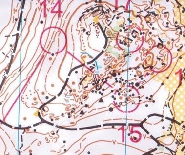
PG:
#14, from day 5 at O'Ringen, is a candidate for the smallest reentrant I've ever seen mapped, and it was even used for a control point too!
My occasional complaints about hard-to read (impossible to read?) maps have been met with advice to get a magnifier. We're already enough of a geek sport.
My occasional complaints about hard-to read (impossible to read?) maps have been met with advice to get a magnifier. We're already enough of a geek sport.
Aug 6, 2013 3:38 PM
#
Surebridge has way smaller re-entrants than that mapped, they're just drawn a lot bigger. But, yes.
Aug 6, 2013 5:21 PM
#
O-Ringen maps were filled with non standard symbols and mapping, like dotknolls smaller than stones (size only about one fourth of the minuimum), triple form lines (only one is allowed), cliffs with width of the contour and so on. If printed at 1:5000 scale those maps would have been as readable as properly mapped maps in 1:10 000. And even worse, these disgusting maps and mapping style is used as examples in developing O countries, so I would say those Swedish mappers who keep on mapping major event maps like this are sort of the cancer of our sport, spreading bad behaviour around the globe. IMHO.
It feels kind of pointless to argue, but:
1. At day 1, 2 and 3 of O-Ringen the maps were printed at 1:15000 for classes HD16-HD21 and there were very few complaints about unreadable maps.
2. I'm pretty sure there are no non-standard sized dotknolls on the maps for day 1, 2, 3 and 4. Only on the day 5-map that was re-drawn from scratch this spring were they used for some reason. (Lazyness and hurry?)
3. The mapping of contours and formlines pretty much followed typical swedish standard and I can't find much formline-clutter on any of the maps. Different mapping styles when it comes to contours seems to be a non-issue on the international level. In most parts of the world they are perfectly happy if they can find a mapper who understands contours and dares to change what they see on the basemap.
4. There were some non-standard usage of symbols (mostly due to strange military remnants in the woods) but those were all thoroughly explained in the meet-notes.
In my opinions there were som issues with the maps for this years O-Ringen but mostly smaller stuff like inconsistency between the days in the representation of bare rock. (Day 1 old Swedish style with just yellow, day 2 and 5 mix of yellow and grey, day 3 and 4 Finnish style with frivolous usage of grey.) Sure, the maps could have been better, but that is almost always the case, and northern Sweden has some special problems with a short mapping season and shortage of mappers willing to spend enough time that far up north.
Aug 6, 2013 7:03 PM
#
Gil:
this was in Finland but several years ago, I was told that the sting course would take some round-a-bout route while a more direct route was available off string. The idea was that the kids that chose and successfully did the off string route were rewarded with a faster time. I should note that the string course there seemed quite long and appeared more geared toward the young white runner than a toddler.
I think that is fantastic idea! It's almost assures that orienteer cannot get lost but still dares you to explore navigation. Does anyone have any info if it is still practiced in Finland and what are the impacts?
I think that is fantastic idea! It's almost assures that orienteer cannot get lost but still dares you to explore navigation. Does anyone have any info if it is still practiced in Finland and what are the impacts?
Aug 6, 2013 7:27 PM
#
bubo:
In Sweden all major events have a course (Inskolning, 'schooling in') where the happy and/or sad faces (mentioned by Nixon above) are posted in strategic places on the course where there's a chance to make a (wrong) choice of route. You can do it alone or with a parent - times are never posted.
The course is not taped, but that system is used in Czech Republic. There they have two courses - T10 and T10P - that are taped and can be done alone or with a parent. I don't know if you're supposed to/allowed to take your own short-cuts if you're skilled enough...
The course is not taped, but that system is used in Czech Republic. There they have two courses - T10 and T10P - that are taped and can be done alone or with a parent. I don't know if you're supposed to/allowed to take your own short-cuts if you're skilled enough...
Aug 6, 2013 8:25 PM
#
I only jogged one day of Oringen, and I had no complaints (at the time, anyway), beautiful terrain, beautiful terrain. And if we got these maps in Ireland we'd be delighted. But some things which could be improved upon the earlier days (and sure, terrain like this it will be hard to map 'perfectly')...
Day 4: http://www.lid1.se/erik/doma/show_map.php?user=eri... - check out the form-lines around the big marsh SW of 13. It doesn't help that there's a slope tag under the circle, but even then, there's a branching form-line by the boulder south of the marsh. Any idea which way is up and which is down?
Day 3: http://www.lid1.se/erik/doma/show_map.php?user=eri... form-lines again, west of 8, at the top of the indistinct trail. At least there one can work out what's going on. Even on the 1:10 the elongated dot knolls (eg s of lake at top of the ski slope hill) seem small. At 1:15, well...
Day 2: excessive use of form-lines near 13...
Day 1: Forget the stacked form-lines (eg at 13). Choose a contour, any contour, between 13 and 14, and try to follow it. http://www.lid1.se/erik/doma/show_map.php?user=eri...
PG, where did you get the clean map extract?!
Aug 6, 2013 11:23 PM
#
Here's another thing I liked. Several short videos were produced at the O-Ringen and posted quickly on youtube. I think this kind of production, rather than the live video produced at major championships, has a great potential to promote the sport. It gives a good feeling for what the event was like. Admittedly, the O-Ringen has a lot of money to throw around but the crew that produced these videos was very small - it may have only been a couple of people. You could criticize some of the artistic choices but all in all they are very watchable. You can find them here: https://www.youtube.com/user/oringenofficial
The one title "sista etappen" (last stage) is especially nice with some great shots of Thierry and Tove.
The one title "sista etappen" (last stage) is especially nice with some great shots of Thierry and Tove.
Aug 7, 2013 10:17 AM
#
I was told that the sting course would take some round-a-bout route while a more direct route was available off string.
Can be good, but ...
My son did one of these aged 7 in France. Worst ever O-experience: follow path 5-6, follow tapes 6-5, path 5-6, tapes 6-5 repeat until breaking down in tears (and unable to communicate with the nice French people trying to help him).
Similarly, smiley faces on the right route for M10B inevitably means that somewhere there are smiley faces on the wrong route for M10A. It can be made to work, with colour coding, but only if the kids know exactly what to expect.
Aug 7, 2013 11:35 AM
#
Just do what we do in West Aus and have so few juniors that the idea of a 10A and 10B course is laughable.
Aug 8, 2013 6:03 AM
#
Several levels of form lines are often easy to understand wrong if just one tag is missing. In additin, it gives wrong impression of elevation differences, steepness changes and climb. For example #5 at http://www.lid1.se/erik/doma/show_map.php?user=eri...
there is two form lines above control, making steepness (brownes, brown line density) look pretty much the same above and below the control. But in reality it is four(!) times steeper below the control, based on full contours. The steepness change is the most distinct feature there and essential to spike the control. That is easy and simple case, often there is cliffs and stones and green making it harder to see are lines form lines or not. Anyway, here the mapper has made good job hiding the most distinct feature. Terrains should be our challenge, not maps.
Problems with stacked and short form lines has been known for decades, and solution has been also in use for decades: having just one level between two full contours. It was like that in ISOM 1990 and ISOM 2000 and it's written clearly in all national versions of ISOMs, also in the Swedish one. Saying breaking rules is ok because others do it too is lame (that attitude is exactly the cancer thing, and that reasoning sounds awfull lot like the other problem many endurance sports have).
It would not do that much harm, but the leading nation happens to be the worst in this, so it is easy to claim anywhere it's ok because they do it in Sweden too, so it must be the way of the future. The stacked form line problem has been pretty much nonexistent in last three WOCs (just look at WOC 2012 maps), so the problem is identified and correction moves made in many countries, but the leading nation refuses to do any actions, instead they introduce new violations like these mini dotknolls and miniature cliffs (PG's clip, mini cliffs at center of the map, also at top center).
Eriol,are you the mapper behind Gyllergen map? http://www.sttunaik.nu/kartor_ny/Gyllbergen.png
I think you may be so deep inside this from line clutter mapping thing you just can't see it, it is quite easy to understand you accept any violations. It would be nice to hear what is the reasoning from mappers perspective for mapping like that, obviously there hasn't been no attemps whatsoever to use only one level there. That is agains all recommendations and guidelines, including Swedish ones, so guestion is why? Money?
Feedback is all we can do, so better let mappers and event organizers hear their maps are bad every time you see maps mapped like that.
Aug 8, 2013 8:49 AM
#
What I find most surprising about these examples Jagge's posting is just how unnecessary the vast majority of these stacked form lines are - most of them seem to be solvable by just using one formline and bending it a bit more.
From my armchair it looks like the contour version of over-mapping rock detail, where the mapper is determined to include every tiny little feature.
From my armchair it looks like the contour version of over-mapping rock detail, where the mapper is determined to include every tiny little feature.
Aug 8, 2013 10:15 AM
#
I thought ISOM was pretty clear in that you can only have one form line between contours. I'm no (bush) mapper myself but even I know that one!
Aug 8, 2013 11:52 AM
#
What would be useful is to compare say a snippet with 0.5m contours and how it got mapped with stacked form lines. Just looking at the final result does not explain why.
Aug 9, 2013 12:02 AM
#
Lidar derived 1 metre contour base maps make it much more tempting to stack form lines.
Aug 9, 2013 12:17 AM
#
Post a JPG of each course for each event.
People are going to scan the maps anyway, so why not post a good copy of the map, so that what is out there is not some crappy looking replicate of the course map?
People are going to scan the maps anyway, so why not post a good copy of the map, so that what is out there is not some crappy looking replicate of the course map?
Aug 9, 2013 2:54 AM
#
Actually the ISOM is not perfectly clear on "one form line", on two counts.
First, from 111 knoll- "Smaller or flatter knolls should be shown with form lines."
Does this mean that showing a low knoll occuring high in the interval, with a form line , means that another form line near the middle of the interval would need to be deleted? It doesn't say that, and I'll suggest that would be absurd, therfore a double form line would reasonably be permitted, almost required, if the upper form line is a low knoll.
Secondly from 103 form line- "Only one form line may be used *BETWEEN NEIGHBORING CONTOURS."
This language leaves the door open for multiple form lines on the top of hills and the bottom of depressions, where the terrain is not between contours. I don't know if this is intentional or not, since this is a difficult concept to describe otherwise. It might depend on who you ask. Nevertheless this "exception" is consistent with the first point.
Aug 9, 2013 3:02 AM
#
For your first point, 'may' is more definitive than 'should', and regardless the definition for formline would override the suggestion to use form lines for small knolls. So:
Yes. It means exactly that. Seriously, if you've got a knoll small enough that it falls between the 2.5m and 5m contours, is too broad to be a dot knoll and is too small to be incorporated into either contour (particularly since the spec allows you to fudge the major contour by up to 25% to incorporate a knoll), then I'd suggest you're imagining the bloody thing.
Does this mean that showing a low knoll occuring high in the interval, with a form line , means that another form line near the middle of the interval would need to be deleted?
Yes. It means exactly that. Seriously, if you've got a knoll small enough that it falls between the 2.5m and 5m contours, is too broad to be a dot knoll and is too small to be incorporated into either contour (particularly since the spec allows you to fudge the major contour by up to 25% to incorporate a knoll), then I'd suggest you're imagining the bloody thing.
Aug 9, 2013 3:05 AM
#
This language leaves the door open for multiple form lines on the top of hills and the bottom of depressions
Multiple small knolls/depressions? Sure. Multiple nested knolls/depressions? No. Even if you could get a lawyer to drive a truck through the loophole the intention is clear.
Aug 9, 2013 4:00 AM
#
In defense of the Gyllbergen map-
This map looks quite clean to my eyes, certainly not cluttered with form lines, or other details, compared to the stuff in PG's example east of 14. Granted, this is partly a function of terrain, but I suspect the mapper deserves some credit as well. I have seen numerous worse examples of Swedish form lines.
Granted, there are some multiple form lines, a few of which might use some tweaking, but not from an armchair, and I think most show a plausibly significant shape. My eye is disturbed by form lines that don't blend into 5m lines, somewhat of a Swedish habit, and there are a couple examples here, and on the Oringen maps.
Also I think the Gyllbergen mapper has done a reasonable job of avoiding long meaningless redundant form lines, the kind which produce a false sense of slope, a habit which is almost the norm in Finland (recent WOC maps excepted?), since we're getting nationalistic.
While we are in nationalistic mode, I think it is also historically inaccurate to portray Sweden as a leader on O mapping. I vividly remember the Swedish WOC where the Norwegians had the motto "full speed on bad maps" (it rhymes better pa Norsk) which I think was deserved at the time. However those WOC maps were good, and at least in my mind, marked a turning point in the Swedish standard, after which they joined the rest of the world, or at least caught up to the USA and Australia :-) , although still don't deserve the title or burden of being the world leader in O mapping.
Aug 9, 2013 11:51 AM
#
Or just stick to contours and varying types of black dashed lines - once you've mastered those Juffy will teach you about the brown dashed lines.
Aug 9, 2013 3:25 PM
#
is almost the norm in Finland (recent WOC maps excepted?)
Well, recent WOC maps are not exception, there is plenty of useless form lines there. I'd say those middle/long maps are actually worse side of the Finnish standard from this perspective. If you compare it to for example this http://kartor.sttunaik.nu/show_map.php?user=peterl... there may be about similar amount of fromlines or even more, but think there is more useless parallel ones in WOC maps.
Having a form line between evey contour is mostly Tampere habit (but used by hobby mappers elsewhere too, unfortunately).
Aug 9, 2013 3:31 PM
#
But then if it is consistent like that -- form line between every contour -- maybe it's okay? If the terrain allows for 2.5m contours then why not use it -- you drop form lines in the areas that are very steep but otherwise just keep them? And clean up the noisy ones?
Aug 9, 2013 4:28 PM
#
no, lots of dashed lines / gaps make it look bad.
The legendary map from 2002:
http://www.kangasalask.fi/extrat/20020908_hrv/kuvi...
The legendary map from 2002:
http://www.kangasalask.fi/extrat/20020908_hrv/kuvi...
Aug 18, 2013 3:44 AM
#
I was going to post something in this thread a long time ago, but then I got kind of disconnected to the internet for a while and then EricW said almost everything nuch better than I could. Anyway, I'm not totally happy with the way the Gyllbergen map has turned out, but it was sort of a learning project that started 11 years ago and quality of the map varies quite a lot between newer and older parts. If I started remapping the whole thing I'm sure it would be much better, but since the only people who seem to complain very much about it are the finns I won't bother with that. :)
Now I also remember that I started this little project a long time ago (but never got around to showing it to anybody):

A is 1 meter lidarcontours on a southfacing slope. For this experiment it's considered the "true" form of the land.
B is the 5 meter levels.
Which of C-H are correct ways of drawing contours according to ISOM? Which are the preferred ways? What problems do you see with the different depictions?
Now I also remember that I started this little project a long time ago (but never got around to showing it to anybody):
A is 1 meter lidarcontours on a southfacing slope. For this experiment it's considered the "true" form of the land.
B is the 5 meter levels.
Which of C-H are correct ways of drawing contours according to ISOM? Which are the preferred ways? What problems do you see with the different depictions?

Aug 18, 2013 5:12 AM
#
I note that none of D–G have the formline at the correct 2.5 m level.
Aug 18, 2013 5:54 AM
#
I've wondered about this mapping issue ever since I've been orienteering. Jagge's answer, of course, does not show the little hilltop. The contours would look exactly the same if there were no hilltop at all--just a spur.
So when you see a contour line like the middle one in Jagge's example, should an orienteer take the view that there may or may not be a hilltop there, and prepare for the landform to take either shape? That bothers me, and personally I am of the opinion that the hilltop should be mapped, as in all of the examples above.
So when you see a contour line like the middle one in Jagge's example, should an orienteer take the view that there may or may not be a hilltop there, and prepare for the landform to take either shape? That bothers me, and personally I am of the opinion that the hilltop should be mapped, as in all of the examples above.
Aug 18, 2013 8:25 AM
#
Not sure about the hilltop - would have to go there to see if there is a rise from the spur. There is definitely something happening in the NE and Jagge's is the only version that shows it. Are there any significant (>2.5m) cliffs and rock outcrops? They must be adjacent to either a contour or form-line.
Aug 18, 2013 10:42 AM
#
Formlines are not contours at the halfway level. They are lines used to show significant terrain shapes that don't show up in the contours.
Jagge's answer may well be fine, but that's not what Eriol asked. He asked which of the things he showed are legit under ISOM. As to how the map should be drawn, there's no way to know without seeing the terrain. It's completely possible that the little hill is actually so visually insignificant that it should not be shown at all. Or maybe as a spur. Or maybe as some kind of hill.
Jagge's answer may well be fine, but that's not what Eriol asked. He asked which of the things he showed are legit under ISOM. As to how the map should be drawn, there's no way to know without seeing the terrain. It's completely possible that the little hill is actually so visually insignificant that it should not be shown at all. Or maybe as a spur. Or maybe as some kind of hill.
Aug 18, 2013 10:50 AM
#
Jagge's right.
H may also have a problem of mis-communicating the slope change north of the spur, making it look steeper right at the spur level and leveling off further north, which is wrong.
H may also have a problem of mis-communicating the slope change north of the spur, making it look steeper right at the spur level and leveling off further north, which is wrong.
Aug 18, 2013 4:42 PM
#
The lowest ponint north of the knoll, saddle, how low is that? It's so much closer to the upper contour than the lower one I'd say it's just something like 20 cm below the knoll ring contour. There is only one ring, so knoll rises less that 1 m above the ring. If it rises almost that one meter (80..99 cm) inside the ring it may hit alltogether the 1m minimum of dotknoll, then I'd say it is high and sharp enough and should be mapped as a dotknoll. But more likely it rises a lot less inside the ring, I guess it is just a 50cm bump alltogether and a spur would do just fine. It's too small for a dotknoll and a knoll ring might make athelte expect something more prominent than a knee high bump (would it be consistent, is every about knee high bump mapped anyway if interval is 5 meters?). Thats how I ended up suggesting that.
What it comes to the actual question, I think D is not correct because there is two form line levels, the rest are ok or at least no ISOM violations. Maybe nost just so well mapped, mostly for giving wrong impression of elevation and steepness changes for form line being a bit too too far from the halfway between full contours.
What it comes to the actual question, I think D is not correct because there is two form line levels, the rest are ok or at least no ISOM violations. Maybe nost just so well mapped, mostly for giving wrong impression of elevation and steepness changes for form line being a bit too too far from the halfway between full contours.
Aug 19, 2013 7:11 PM
#
What would be the preferred way to draw this:

lidar 5m contours, thin ones 25 cm.
lidar 5m contours, thin ones 25 cm.

This discussion thread is closed.