Discussion: what do these map symbols mean?
in: Orienteering; General
Apr 13, 2011 2:45 AM
#
I have studied the IOF map symbology and control descriptors. However I've seen some details on OCAD maps that I don't understand.
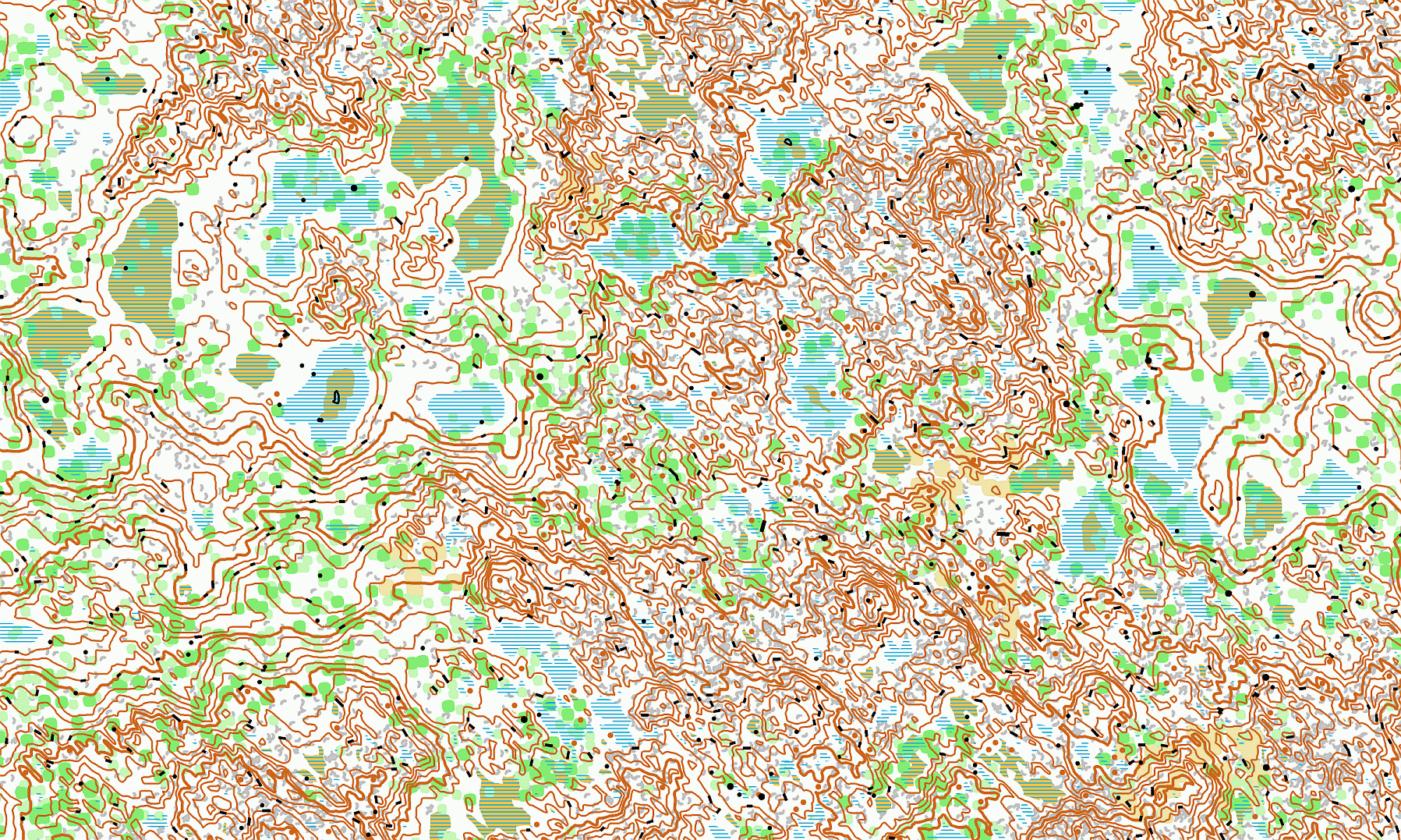
On this map: for the peak on the right, why is the contour line dashed instead of solid?
On this map: why are so many contour lines dashed instead of solid? Are there really that many trails that perfectly follow the contour in such a small area, and start/end in nowhereville? Same thing with this map
On this map: why are the "ovals" at the high point of the peak drawn with dashes?
Apr 13, 2011 2:53 AM
#
The dashed contour lines are form lines.
That is, they symbolize topography in the terrain that isn't significant enough to show in the stated contour interval (2.5m contours, 5m contours, etc.).
However, the mapper felt that these smaller terrain features would be an aid to a navigator, so they were mapped.
For example, in the last example you link, there are 4 dashed ovals on the top of that hill. Say the contour interval of that map is 5m. There are 4 smaller hills on top of that hill that could be 3m tall. Big enough to be noticeable, but not big enough to get a solid contour line.
Apr 13, 2011 3:04 AM
#
Form lines = taller than me, shorter than the contour interval.
(don't you wish they were used on rogaining maps?)
(don't you wish they were used on rogaining maps?)
Apr 13, 2011 3:10 AM
#
I think form lines are supposed to be 2.5m contour lines Jenny, not 1.5m. *hides*
Apr 13, 2011 3:11 AM
#
Excellent, thank you very much.
I knew something was going on because I did find o-maps like this where all the contour lines were solid, which made sense to me since I come from using USGS 1:24k maps.
I knew something was going on because I did find o-maps like this where all the contour lines were solid, which made sense to me since I come from using USGS 1:24k maps.
Apr 13, 2011 3:23 AM
#
Have you run on that map? Wasn't that one generated by some random o-map generator that someone programmed?
Apr 13, 2011 3:43 AM
#
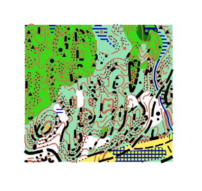
Referring to the original post. On the 4th map, the form line contours defining the four knolls add detail which should be visible and useful for orienteerer and for course setter.
On the first 3 maps, would you prefer to run on the given map or on the same map with (nearly) all form lines erased?
On the first 3 maps, would you prefer to run on the given map or on the same map with (nearly) all form lines erased?
Apr 13, 2011 3:59 AM
#
Form lines are symbol 103 in ISOM 2000.
You said you've studied IOF map symbology. Have you just looked at map legends or have you gone to the source: the IOF Mapping Commission website?
...Specifically the ISOM 2000 (1 MB pdf) for regular O' maps and the ISSOM 2007 (591 kB pdf for sprint maps.
There are also specs for MTBO and Ski-O.
You said you've studied IOF map symbology. Have you just looked at map legends or have you gone to the source: the IOF Mapping Commission website?
...Specifically the ISOM 2000 (1 MB pdf) for regular O' maps and the ISSOM 2007 (591 kB pdf for sprint maps.
There are also specs for MTBO and Ski-O.
Apr 13, 2011 9:31 AM
#
@ Juffy - she did say taller than her. But actually a form-line needn't be taller than jennycas - it could be used for a 1m feature if it is distinct enough in the terrain, eg a low knoll too broad to be shown with a brown dot.
@Ricka - While you have a point about mappers tendency to be profligate with form-lines, I think the only one of the maps which has some unnecessary ones is No. 2.
@Ricka - While you have a point about mappers tendency to be profligate with form-lines, I think the only one of the maps which has some unnecessary ones is No. 2.
Apr 13, 2011 1:00 PM
#
Ooh, ooh, I can identify map #2! (And I didn't even draft it, but I did have to pull a folder out of my desk drawer to figure out which map it was, although I did locate it within 10 miles just by looking at it, even though I've run on it only once.) I've seen maps with excessive form lines, but this isn't one of them, in fact, after running there, I said it was on the short list for my favorite among all the maps I've ever run on.
Apr 13, 2011 1:57 PM
#
Yeah, I'd disagree with simmo there too... on the other hand, I think the Finnish map has a few unnecessary ones.
Perhaps we could start wiki-map-revising Finland. It might make Jagge happy.
Perhaps we could start wiki-map-revising Finland. It might make Jagge happy.
Apr 13, 2011 3:14 PM
#
I didn't say all the form-lines on map 2 were unnecessary, but some of them have been continued for too long, and they don't add information because for most of their length they parallel the contours on either side. On the other hand, just about every part of every form-line on map 3 provides some useful information to the orienteer.
Apr 13, 2011 3:18 PM
#
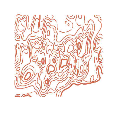
As an example of what too many form lines does look like, consider a map that I was called upon to make some adjustments to, about a decade ago. Here's a snippet of the map:
Kind of cluttered, and let's see what it looked like showing just the contours and form lines:
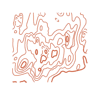
Clearly redundant and distracting information there. It's a 5m interval map, but the mapper practically used a 2.5 m interval. It's too steep for that to be appropriate. So the decision was made to identify the unhelpful form lines so that they could be hidden, leaving some select useful ones:
Putting back the rest of the features, the resulting map was a lot more readable:

Kind of cluttered, and let's see what it looked like showing just the contours and form lines:
Clearly redundant and distracting information there. It's a 5m interval map, but the mapper practically used a 2.5 m interval. It's too steep for that to be appropriate. So the decision was made to identify the unhelpful form lines so that they could be hidden, leaving some select useful ones:
Putting back the rest of the features, the resulting map was a lot more readable:
Apr 13, 2011 3:22 PM
#
Huge improvement! Nice example of why un-needed form lines make maps more confusing to read.
Apr 13, 2011 5:06 PM
#
Nope. Anybody else want to take a stab at it? It is... of some interest.
Apr 13, 2011 5:12 PM
#
bmay:
Now, it would be great if you would go out into the forest, remove every second tree. Then you could turn the green to white and it would be that much more readable!
Apr 13, 2011 5:13 PM
#
ken:
I recognized the map-of-interest right away, but will let others guess. I also had one of those controls on map #2 above, though I missed it rather badly.
Apr 13, 2011 5:23 PM
#
The mid-green was fallen hemlock (trees), ants and fungus have done a job and it is more white than green now.
Quite how Cristina has a digital copy of the map I don't want to know...
Quite how Cristina has a digital copy of the map I don't want to know...
Apr 13, 2011 7:07 PM
#
Yeah, I would certainly hope Neil knows this map, and ken presumably has fond memories of it. I can also see why Cristina would want it on her desktop about now. There was an A-meet on the version with the extra form lines; I just pulled out one of my race maps from that meet, and the whole map looks like it's vibrating.
Apr 13, 2011 8:29 PM
#
Nice example. Where is the like button? You could have nuked the last form line by dropping the index contour level a bit, just enough to take home those cliffs now on the form line.
Apr 14, 2011 2:04 AM
#
cedarcreek sez: "Have you just looked at map legends or have you gone to the source..."
You are right, I studied map legends and the symbol lists but not the map standards. Great links, thank you! It helped a lot.
Cristina sez: "omaps.worldofo.com is a wonderful thing"
Another great resource. I found a few maps there that included the runner's GPS track with green/yellow/red light color coding. It is very interesting and helpful to me to see the route other orienteers select.
Apr 14, 2011 2:23 AM
#
I am intrigued by the thought of trying to learn orienteering 'by the book', so to speak. Not dismissing the concept, but most of us picked up what we know by 3-dimensional map-to-ground exposure (and possibly trial & error over many years).
Apr 14, 2011 2:39 AM
#
re: "by the book"
There are no o-clubs in my state at all, I have to travel to one of the 2 neighboring states to find just a simple o-event. So learning about route selection & terrain association from others' experiences is helpful to me. I don't know any locals here who do o-stuff, so I have no mentors. I'm doing green courses now so I'm putting in the field time when I have the opportunity. You might be surprised at how valuable playing Catching Features has been for me!
It's like a 1-man birthday party: you don't get any presents you didn't bring for yourself.
Apr 14, 2011 2:45 AM
#
feet:
... where, for Australians, US green means 'relatively short red;' Australian 'green' = US 'yellow.'
Apr 14, 2011 2:49 AM
#
Except in Western Australia where they run with confusing course names like Very Easy, Easy, Moderate, and Hard 1-4 or 5 for the different length hard courses...
Apr 14, 2011 2:51 AM
#
We in South Australia haven't had colour coding of course difficulty any time in the last 26 years. Before that, I can't say.
Apr 14, 2011 2:52 AM
#
And the colo(u)rs in the UK have different meanings too. US "Green" = UK "Blue".
Apr 14, 2011 3:00 AM
#
re: course ratings - lolz! Reminds me of the detailed UK ratings for rock climbing. Here in the US it's a pretty simple numerical scale. The Brits like more descriptive terms like "HVD: hard very difficult", "MVS: mild very severe", and the legendary "EDPDOASM: extreme double-plus death on a stick, mate!".
Apr 14, 2011 3:06 AM
#
There are no o-clubs in my state at all, I have to travel to one of the 2 neighboring states to find just a simple o-event.
A couple of suggestions:
1) Play Catching Features.
2) Participate in MoboGoGlobo! next year.
A couple of suggestions:
1) Play Catching Features.
2) Participate in MoboGoGlobo! next year.
Apr 14, 2011 5:41 AM
#
Perhaps we could start wiki-map-revising Finland. It might make Jagge happy.
I could act as a remote sensor. Run around aimlessly with gps, head cam,and altimeter, post all data to AP's session video viewer to be watched by remote mappers.
I could act as a remote sensor. Run around aimlessly with gps, head cam,and altimeter, post all data to AP's session video viewer to be watched by remote mappers.
Apr 14, 2011 11:40 AM
#
Re course colours, surely there should be some standardisation to make life easy for the colour blind?
Apr 14, 2011 12:36 PM
#
No, US Green is pretty much UK Green. Then US Red is UK Brown, and US Blue is UK Black. Or at least it was before the UK got all these shorts involved. Or at least that's how it works on the East Coast!
Apr 14, 2011 1:27 PM
#
My translation for the advanced courses has always been:
US Brown=UK Green
US Green=UK Blue
US Red=UK Brown
US Blue=UK Black
(same as yours for the last two), but I admit my experience of UK orienteering is somewhat dated. Either way, having different names for similar courses is confusing (especially for Red, which when I still was in the UK was a fairly long but relatively easy course, but in the US is a long advanced course).
Apr 14, 2011 1:44 PM
#
I definitely agree on that last point. Where did the use of colours come from originally? The direct translation of courses is probably either of our ways now I come to think of it, depending on the size of the event and which courses they actually offer! For the green I was going by what my Mum runs, which was green in both countries last fall. Black is a bit of a new addition (and an old, old one which wasn't used much for many years) and still not available at many events.
It's all a bit silly, isn't it?
It's all a bit silly, isn't it?
Apr 14, 2011 1:44 PM
#
Re Map 2. I thought I'd identified which part of the world it was from as well, but can't find that particular snippet in my collection of maps from that area. I'm intrigued to know which map it actually is.
Apr 14, 2011 1:52 PM
#
And I'm confused: is "map 2" the 2nd one linked at the top of the page, or the one J-J revised to remove some form lines?
I have a guess on the second one I listed, but not the first.
I have a guess on the second one I listed, but not the first.
Apr 14, 2011 1:53 PM
#
John, I do apologise for my tone with my first reply this morning. Must have woken up in a bad mood, didn't mean to appear so snappy!
Apr 14, 2011 1:58 PM
#
@Becks - no problem
@JanetT - I mean the second one linked in the original post (which I believe is the one referred to in jjcote's first post in this thread) - i.e. this one
@JanetT - I mean the second one linked in the original post (which I believe is the one referred to in jjcote's first post in this thread) - i.e. this one
Apr 14, 2011 4:19 PM
#
For awhile there I thought I was in a Monty Python skit- "What's your favorite color? Red, green, NO BLUE..."
Apr 14, 2011 7:01 PM
#
Apr 14, 2011 11:08 PM
#
Considering I had the leg on the originally posted map, I should have recognized it. US Classic Champs 2008, day 1, red course.
Apr 15, 2011 12:31 PM
#
There no problem for the colorblind with using colors, because you never really have to look at the color of a course and identify it, they're just arbitrary names. Instead of Brown, Green, Red, and Blue, they could just as well be called Giraffe, Tornado, Martini, and Hermione.
For the US system, I think the history is that there were originally four courses in increasing levels of length and difficulty, called White, Yellow, Orange, and Red, which seems fairly sensible. Then a longer version of Red was needed, for which the name Blue was chosen, a bit harder to understand. After that, a shorter Red was needed, and it was... Green. So much for any kind of spectral progression. I was around by the time that a need was found for a shorter Green, and that was... Brown? Not even a primary or secondary color (Purple was still available). I think at one time there was a Gray course in Canada, before they switched to using numbers (that are not consistent between events).
For the US system, I think the history is that there were originally four courses in increasing levels of length and difficulty, called White, Yellow, Orange, and Red, which seems fairly sensible. Then a longer version of Red was needed, for which the name Blue was chosen, a bit harder to understand. After that, a shorter Red was needed, and it was... Green. So much for any kind of spectral progression. I was around by the time that a need was found for a shorter Green, and that was... Brown? Not even a primary or secondary color (Purple was still available). I think at one time there was a Gray course in Canada, before they switched to using numbers (that are not consistent between events).
Apr 15, 2011 1:29 PM
#
bubo:
In Sweden we´ve never really used the color coded system to name our courses. The number of competitors is usually large enough to merit separate courses for each age category using their own name (H21E, D50 etc.).
In describing course difficulty color codes have been used for some time though and we sometimes talk about it in terms of color. There are also guidelines available for each level of difficulty using the color coded system.
Links in Swedish, but I think you´ll get the general idea...
In describing course difficulty color codes have been used for some time though and we sometimes talk about it in terms of color. There are also guidelines available for each level of difficulty using the color coded system.
Links in Swedish, but I think you´ll get the general idea...
Apr 15, 2011 2:11 PM
#
Hey, cut me some slack, I'm a Daltonist! (Well, technically not, it's protanopia rather than deutaranopia, but close enough.) And it was mostly just an opportunity to say "Giraffe, Tornado, Martini, and Hermione", which I think was entirely worth it. I'm now old enough to run Tornado, but I just signed up for Hermione at the next A-meet.
Apr 15, 2011 2:59 PM
#
What about chipmunk, rabbit, and roadrunner? To that we could add other critters such as deer, antelope, attack badger and flying pig! And if Tooms was looking for this control,  he'd have to change his tune to Oh Deere!
he'd have to change his tune to Oh Deere!
Apr 16, 2011 11:42 AM
#
Our Learn to Swim program at work has stages going as follows:
Minnow - Yabbie - Crocodile - Dolphin as the kiddies progress.
My 4 year old nephew in Albany has just gone from Sea Dragon to Starfish. (I asked him how a starfish could possible swim better than a sea dragon, but he knew I just "didn't get it"!).
Minnow - Yabbie - Crocodile - Dolphin as the kiddies progress.
My 4 year old nephew in Albany has just gone from Sea Dragon to Starfish. (I asked him how a starfish could possible swim better than a sea dragon, but he knew I just "didn't get it"!).
Apr 16, 2011 3:17 PM
#
I had to look up "Yabbie". Do they actually swim, or just crawl on the bottom?
Apr 17, 2011 1:40 AM
#
For those who didn't get it, chipmunk, rabbit, and roadrunner are award levels in Orienteering USA's Little Troll program of stickers and patches for children doing beginner level courses with varying levels of adult assistance. If your club does not have a supply of Little Troll cards and stickers, why not?
Apr 17, 2011 8:32 AM
#
@jj they crawl along the bottom and I think they can kind of flick their tails to spring forward (or backward?) if necessary. In the southwest of Western Australia it seems to be a rite of passage to go "yabbieing" in the freshwater rivers and dams.
Now, from a navigational animal labelling of courses, what animal is the epitome of navigational excellence. Would the toughest o-course be labelled "Homing Pigeon" or "Salmon"?
Now, from a navigational animal labelling of courses, what animal is the epitome of navigational excellence. Would the toughest o-course be labelled "Homing Pigeon" or "Salmon"?
Apr 17, 2011 1:19 PM
#
For rogaining, how about a bar-tailed godwit. In 2007 godwits were satellite tracked making nonstop flights from Alaska to New Zealand, 7100 miles (just under 12,000 km) in just over 8 days, And Arctic terns log close to 50,000 miles (80,000 km) per year.
Oh, how far we have strayed from "what do these map symbols mean?"
Oh, how far we have strayed from "what do these map symbols mean?"
Apr 17, 2011 2:12 PM
#
Yes, but if we hadn't strayed that far, it just wouldn't be attackpoint.
Apr 17, 2011 8:40 PM
#
And Arctic terns log close to 50,000 miles (80,000 km) per year.Oh sure, but they probably log 57-hour weights sessions too.
Apr 18, 2011 8:28 AM
#
In the interest of continued AP education... I mean, digression, I'll add a non-flight creature to the list with its 'natal homing' system. The sea turtle.
This discussion thread is closed.