Discussion: Imaginative landscaping
in: Orienteering; General
Mar 11, 2010 2:45 PM
#
Designing a new logo is one thing, but designing imaginative maps is much more important and useful. See My Way in today's NYT.
Drawing the map first and then building the landscape accordingly is the future in orienteering!
Drawing the map first and then building the landscape accordingly is the future in orienteering!
Mar 11, 2010 8:04 PM
#
In some European sprints they build mazes with crowd control barriers. But I imagine more, like building a variation of Harriman in the Meadowlands. Or in Texas.
Mar 14, 2010 7:05 PM
#
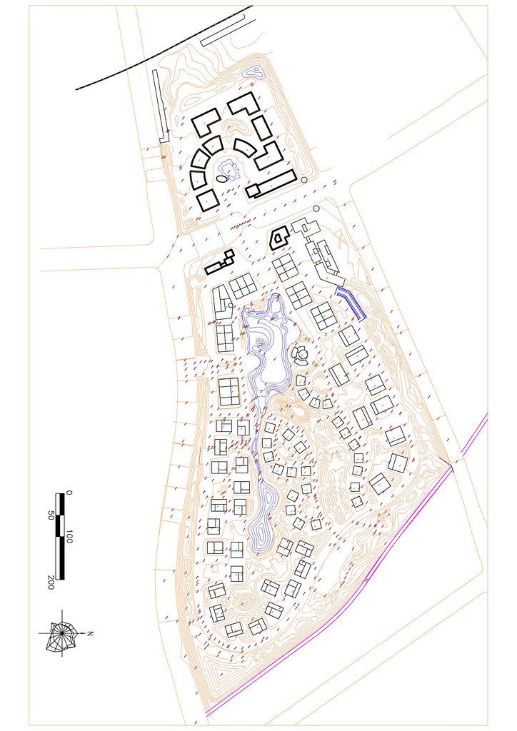
Or you could have a job like mine and get to design the landscape on massive sites in china!
Business Park Contours
Business Park Contours
Mar 14, 2010 9:24 PM
#
Nails,
are there any conflicts between feng shui guidelines and sprint orienteering areas?
From what I've seen in China the developer would probably be very happy if you could make the park look like Versailles.
are there any conflicts between feng shui guidelines and sprint orienteering areas?
From what I've seen in China the developer would probably be very happy if you could make the park look like Versailles.
Mar 16, 2010 9:18 PM
#
MNOC had a maze section at the end of one of our night sprints last fall.
The maze was easily constructed using fiberglass fence posts with plastic web type fencing (snow fence or construction site fence) fastened to them . It was a blast for both the runners and the course setter (since I could actually design the "terrain" as well as the course).
The maze was easily constructed using fiberglass fence posts with plastic web type fencing (snow fence or construction site fence) fastened to them . It was a blast for both the runners and the course setter (since I could actually design the "terrain" as well as the course).
Mar 18, 2010 12:05 PM
#
I've long wanted terrain that can be created to order. I wonder if there is scope for influencing what happens when mining or landfill companies are required to reinstate the terrain?
On the sprint scale its all about barriers, isn't it. Parking barriers and plastic fencing have been cited. How about designing a "steel boulder field" and creating it (when people arrive) by requiring them to park according to a preset plan. What other mobile features can we think of?
On the sprint scale its all about barriers, isn't it. Parking barriers and plastic fencing have been cited. How about designing a "steel boulder field" and creating it (when people arrive) by requiring them to park according to a preset plan. What other mobile features can we think of?
Mar 19, 2010 5:14 PM
#
How about designing a "steel boulder field" and creating it (when people arrive) by requiring them to park according to a preset plan.
I love it!!!
I love it!!!
Mar 19, 2010 9:49 PM
#
I've had similar thoughts to Gruver re mining. We have open cut coal mines up the valley in our area and they re-landscape it afterwards. It would be good to get on board and see how easily it would be to design something useful.
As far as I know the places they have already re-landscaped are still off limits as yet, and don't look very interesting orienteering wise.
As far as I know the places they have already re-landscaped are still off limits as yet, and don't look very interesting orienteering wise.
Mar 20, 2010 9:53 AM
#
Most of the open-cut coal mines have too much spoil to dump for the area they have available, so they form large mounds at the maximum allowed slope, with no volume wasted on interesting (to us) gullies and re-entrants, and no large rocks left exposed on the surface as point features. The result is very even slopes with almost no orienteering potential, even after forest growth.
To maximise the orienteering potential you have to do something like the 19th century gold miners in Victoria - clear all the timber, dig pits and shafts, construct contour ditches to run water around the hillsides,reshape the ground by sluicing the surface, build mounds of rocks, let the erosion continue uncontrolled - and then walk away from the area and let it recover naturally, with the addition of introduced blackberries, briars etc. When they did it "right" no-one else wanted the land for a hundred years because it was such a barren wasteland, until the orienteers came along ( and the land had been preserved as a heritage site).
To maximise the orienteering potential you have to do something like the 19th century gold miners in Victoria - clear all the timber, dig pits and shafts, construct contour ditches to run water around the hillsides,reshape the ground by sluicing the surface, build mounds of rocks, let the erosion continue uncontrolled - and then walk away from the area and let it recover naturally, with the addition of introduced blackberries, briars etc. When they did it "right" no-one else wanted the land for a hundred years because it was such a barren wasteland, until the orienteers came along ( and the land had been preserved as a heritage site).
Mar 20, 2010 10:29 AM
#
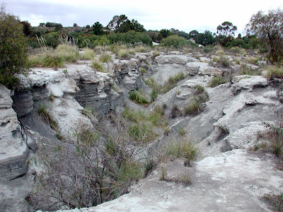
I think you are describing next week's Bendigo Orientshow. Mining wasteland in the middle of suburban Eaglehawk, now being slowly recast as heritage parkland. It took forty hours to map and draw 0.7 square kilometre of terrain. I am a slow novice mapper, but I had an excellent basemap with 1 metre contours and an underlying high detail aerial image. We had to explain to the Council that we really value these pockets of land throughout Bendigo and they can be used to bring visitors to the town. It was a very new concept to them. The new mine in town has covered over one of these areas with spoil heaps just as you describe Rockman. No use to us at all.
 |
| From Virginia Hill |
 |
| From Virginia Hill |
 |
| From Virginia Hill |
Mar 20, 2010 2:39 PM
#
Lots of bauxite mining happens near Perth, usually in fairly featureless Jarrah/Marri forest. Back in the 70s Alcoa used to leave a nice and unusual orienteering terrain after mining, with lots of cliffs and knolls. Then they would just plant pine or blue gum. Would have made for great events. Then the Dept of Environment stepped in and said 'You've got to rehabilitate it' so now Alcoa totally flattens it with dozers and graders. Then they plant an understorey (usually a very orienteering unfriendly wattle known locally as prickly moses) and eventually the original species (Jarrah, Marri - large eucalypts) regenerate to leave the terrain as uninteresting as it was pre-mining. Bah!
Mar 20, 2010 2:44 PM
#
@ iriharding - I'm thinking of using a maze for a major sprint event, but am concerned about (a) fitting it accurately onto the map ...... and (b) then installing it accurately as mapped on the day of the event. How did you overcome these two major potential sources of error and resulting protests?
Mar 20, 2010 5:31 PM
#
Good question:
I followed the practice I have seen at some UK events (reported in CompassSport magazine) where the maze is marked on the map (1;7500 scale) and then there is a magnified inset with 1:1000 scale or similar.
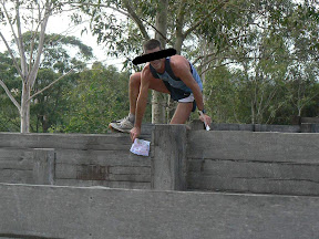
The maze itself I laid out using a squared grid (squared grid paper first then used 30' x 30' grid (with 3' squares) on the ground with 4 epunch controls. I also had lots of distractor controls (both dummy flags (no assigned penalty or punch) and 4 epunch distractor controls (2 min penalty for punching). So we had about 20 flags in the 30' x 30' area (4 bonafide and 4 "penalty " and 12 dummy eyecatching flags) So it wasn't just blast through the maze to the flag, but rather a lot of precision was required . And one more thing this was a night O. This was all positioned in full spectator view by the finish and 3 different courses went through the maze.
The maze was a very definite change of pace/style from the 2 km of city park sprinting that lead up to it. The most successful were those that were able to adjust to that change, so folks went away from the event with good appreciation for that skill.
I followed the practice I have seen at some UK events (reported in CompassSport magazine) where the maze is marked on the map (1;7500 scale) and then there is a magnified inset with 1:1000 scale or similar.
The maze itself I laid out using a squared grid (squared grid paper first then used 30' x 30' grid (with 3' squares) on the ground with 4 epunch controls. I also had lots of distractor controls (both dummy flags (no assigned penalty or punch) and 4 epunch distractor controls (2 min penalty for punching). So we had about 20 flags in the 30' x 30' area (4 bonafide and 4 "penalty " and 12 dummy eyecatching flags) So it wasn't just blast through the maze to the flag, but rather a lot of precision was required . And one more thing this was a night O. This was all positioned in full spectator view by the finish and 3 different courses went through the maze.
The maze was a very definite change of pace/style from the 2 km of city park sprinting that lead up to it. The most successful were those that were able to adjust to that change, so folks went away from the event with good appreciation for that skill.
Mar 20, 2010 10:26 PM
#
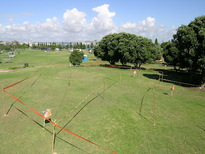
We have run mazes at our end of season breakups for a while now. They have to be topologically correct. Everyone navigates with little idea of the actual scale. Third right, second left etc.
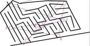 |
| From Presentations and Maze 2006 |
 |
| From Presentations and Maze 2006 |
Mar 21, 2010 12:20 AM
#
awesome maze . I assume you also have a rule that uncrossable lines are also not allowed to be reached over to punch .
Mar 21, 2010 12:54 AM
#
I wonder how relevant such stylized mazes are for orienteering? They would be somewhat more directly relevant for sprints, I suppose, especially complex urban ones, but what about for normal woods orienteering?
Or a corollary--I wonder if the best general purpose orienteers would also maintain their ordinal placings in a maze competition? Would such exercises be a way to evaluate some sort of abstract navigational/route planning IQ? And if so, what predictive value does that IQ have on orienteering results?
Or a corollary--I wonder if the best general purpose orienteers would also maintain their ordinal placings in a maze competition? Would such exercises be a way to evaluate some sort of abstract navigational/route planning IQ? And if so, what predictive value does that IQ have on orienteering results?
Mar 21, 2010 3:16 AM
#
Correct. No reaching allowed. And yes, the maze results tended to reflect results in the forest. Not that anyone took it very seriously. It was followed by a picnic feast and I think most were in a hurry to get to the eating.
Mar 21, 2010 7:26 AM
#
J-man, I hope you're not suggesting that very-detailed-o is invalid unless the top classic-forest-orienteers win.
That's like saying that there's something inferior about street-o (which accounts for 70% of the orienteering in Victoria.) Or that Australian-Rules is better (or worse) than Rugby League or Rugby Union or American Rules or Football or Handball or Baseball. Or that Ed Hillary wasn't much of an athlete because he took a while to do a bit of a trek in Nepal in 1953...
That's like saying that there's something inferior about street-o (which accounts for 70% of the orienteering in Victoria.) Or that Australian-Rules is better (or worse) than Rugby League or Rugby Union or American Rules or Football or Handball or Baseball. Or that Ed Hillary wasn't much of an athlete because he took a while to do a bit of a trek in Nepal in 1953...
Mar 21, 2010 8:11 AM
#
Newcastle club has run promotional events on Australia Day festivities which involved a park/sprint style event and a maze as a separate event. Made from wooden (tomato) stakes and bunting and allowing for very useful natural features eg garden beds and trees it was a great attractor and easily set-up and taken down. Also had an exhibition at Newcastle Regional Museum in 2005 on cartography and had an "interactive" section of a maze using witches hats and plastic chain. (Article in Aus Orienteer mag 2006). Last year one of our Park events used an existing wooden walled maze as the last section of the course. Excellent spectator sport from the viewing platform. Unlike InvisLog's experience some of our best orienteers were well down the rankings in this "elitist" form of the sport. All good fun!
Mar 21, 2010 10:17 AM
#
We probably haven't exhausted areas of detailed existing features - we just haven't thought of them yet. Those pics of Bendigo look awesome, but I reckon we'll think of many more options in the man-made environment.
When we DO decide to set up terrain to order (with hay bales, stakes, bunting, parking barriers, etc, does anyone have any advice on the layout? I mean, the map is made first, and we have to put the features in the right place rather than the more usual other way round. When I've done it with trails marked on a beach I used a grid system, but it was still quite hard. The very large scale makes a consumer-level GPS useless.
PS Woops:just seen that Simmo has asked the same question
PPS Invisible Log you're quite a fast mapper or your terrain is easy. Got mining terrain here that is 100 hrs/sq.km and that is fieldwork only.
Mar 21, 2010 11:49 AM
#
When I have marked out a maze course (which incorporated some garden beds and hedges to "green" it up) I found the best way to spot the corner stakes was to construct one or two long reference lines through the middle of the map, and then measure the distance along the line and the offset left or right for each corner or tape end. Pacing the offset from a 50m tape measure laid out on the ground was good enough for the accuracy of the course , with a small pile of sand at each critical corner so that someone else could bang in the required garden stakes. After the event the sand was rubbed into the grass and there is no permanent mark or effect on the grass.
these mazes was designed for "come and try it" at the Australia Day carnivals on the harbour foreshore, so the paths were deliberately left very wide for prams and wheel chairs
The club has also used an existing maze on a park map, coincidently on an old mine site that is still retains some of the post-mining terrain, but also fairly thick weed cover.
 |
| From Bits&Pieces |
these mazes was designed for "come and try it" at the Australia Day carnivals on the harbour foreshore, so the paths were deliberately left very wide for prams and wheel chairs
 |
| From Bits&Pieces |
The club has also used an existing maze on a park map, coincidently on an old mine site that is still retains some of the post-mining terrain, but also fairly thick weed cover.
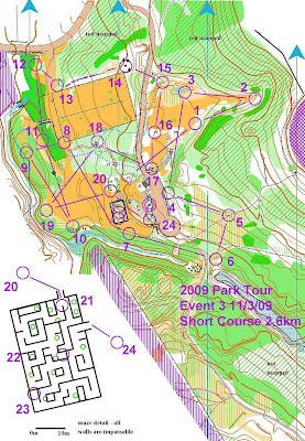 |
| From parkmaps |
 |
| From Club Events 2009 |
Mar 22, 2010 2:59 AM
#
A terrain type we have used: a former aggregate supply location. Is that word widely understood: roading basecourse, gravel, builders mix etc? They dig it out of the ground or in this case an alluvial river, sieve it according to requirements, stockpile it, load trucks and drive it away.
Anyway the operation stopped, the equipment was removed, and vegetation grew over the lumpy ground that was left. Then in came a paintball operation, they made a maze of tracks through the vegetation, and created more obstacles with oil drums, worn-out tires, wooden pallets and shipping containers. Its very good, with track junctions only a few double paces apart. Either one by itself could be good: a disused aggregate depot, a paintball site.
Anyway the operation stopped, the equipment was removed, and vegetation grew over the lumpy ground that was left. Then in came a paintball operation, they made a maze of tracks through the vegetation, and created more obstacles with oil drums, worn-out tires, wooden pallets and shipping containers. Its very good, with track junctions only a few double paces apart. Either one by itself could be good: a disused aggregate depot, a paintball site.
Mar 22, 2010 3:29 AM
#
a paintball site would make for an interesting variation on "attackpoint"
Mar 24, 2010 6:31 PM
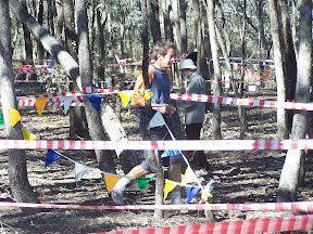
#

This was our 2009 race. We have had one each summer for the last 3 years at a large outdoor show (the biggest in the UK) the cliffhanger. The park is stuffed with thousands of people so its a crazy race. We open it up to kids (and adults) after free of charge. We had about 1500 runs it in about 4 hours!
Mar 24, 2010 7:15 PM
#
That look so deadly!!! My mind was taking abuse even figuring out where the next control is
Mar 26, 2010 5:13 AM
#
A source of inspiration for our sprint series. Which over a dozen years has never completely run out of variations, but some planners are well, less inventive than others...
Mar 30, 2010 11:10 PM
#
The Sheffield mazes are built using metal crowd control barriers, easy to get hold of, assemble, take down and attach banners to so you can't see through them!
Also, Walton Chasers held an event in a Maize Maze last October - check out the Route Gadgets, it was mental! - I found it so difficult, whilst others took to it like a duck to water - those who did well managed to have the maze pretty well sussed by the time of the final, but I managed to do a lap of the area from the control I was looking for xD
Also, Walton Chasers held an event in a Maize Maze last October - check out the Route Gadgets, it was mental! - I found it so difficult, whilst others took to it like a duck to water - those who did well managed to have the maze pretty well sussed by the time of the final, but I managed to do a lap of the area from the control I was looking for xD
This discussion thread is closed.