Discussion: AP 51/13: Best orienteering area in each state, province and territory (was Compass Sport 99)
in: Orienteering; General
Jan 16, 2010 4:07 PM
#
rm:
Apparently, Compass Sport magazine has published a list of the best orienteering area in each of the counties in the UK. (Sort of a cross between a "bucket list" of orienteering areas, and a what-to-do when you're in somewhere-shire.)
Has anyone done a similar list for the 50 American states, or the 10 Canadian provinces?
Has anyone done a similar list for the 50 American states, or the 10 Canadian provinces?
Jan 16, 2010 6:27 PM
#
rm:
For the heck of it, I'll post my own, highly personal, highly incomplete list. But I suspect that some people have even better suggestions.
(In a few cases, I think my personal preference might be rather unique, so I put what I suspect might be a more usual choice for that state or province in {curly braces}. Many states and provinces I've been to, but haven't visited enough to opine on the "best" area.)
AB: Mount Laurie (though also excellent are Barrier Lake, SL Ranch, any of the William Switzer Provincial Park maps north of Hinton, and, if you don't mind bison and rose, the Elk Island maps)
BC: Lost Lake {Six Mile Lake}
MB: Spirit Sands
NB:
NL:
NT:
NS:
NU:
ON:
PE:
PQ:
SK: Ebs Trails
YT: Long Lake
AL: Oak Mountain (any of them, they're all good)
AK:
AR:
AZ:
CA: Anza Borrego {Big Basin}
CO: Crystal Visions (or whatever it's called now...though Buena Vista has some excellent ones too)
CT: Ratlum Mountain {Five Ponds}
DC:
DE:
FL:
GA:
HI:
ID:
IL:
IN:
IA:
KS: Fort Leavenworth
KY:
LA:
ME:
MD:
MA: Boxford State Forest {Mount Norwottuck}
MI: Mission Hill
MN:
MO: Hawn State Park
MS:
MT:
NE:
NV:
NH: Pawtuckaway
NJ:
NM:
NY: Blue Mountain {Surebridge, Moneyhole or Ward Pound Ridge}
NC:
ND:
OH:
OK:
OR: Dutchman Flat
PA: Hickory Run (though Delaware gap has some good ones too)
PR:
RI:
SC:
SD:
TN:
TX:
UT:
VT:
VI:
VA:
WA:
WV:
WI: Telemark
WY: Bisbee Hill
Know of better ones, or have good picks for the blanks above?
Jan 16, 2010 6:48 PM
#
ID: Gold Rush Hills (mining terrain)
NY: Surebridge (in Harriman S.P.) is surely better than Blue Mountain? Though Ward Pound Ridge is a good one too.
VA: Prince William Forest
WI: Cat's Meow (2009 US Champs map; though I haven't been to Telemark).
As for: DE: Elk Neck The park is actually in Maryland.
NY: Surebridge (in Harriman S.P.) is surely better than Blue Mountain? Though Ward Pound Ridge is a good one too.
VA: Prince William Forest
WI: Cat's Meow (2009 US Champs map; though I haven't been to Telemark).
As for: DE: Elk Neck The park is actually in Maryland.
Jan 16, 2010 7:12 PM
#
JanetT beat me to it. But, Elk Neck is a nice place, despite a lot of storm damage a little while back.
Fair Hill rightly belongs to Maryland, but you could almost make a tendentious claim for some other state(s) also.
Fair Hill rightly belongs to Maryland, but you could almost make a tendentious claim for some other state(s) also.
Jan 16, 2010 7:14 PM
#
Cali has got some good stuff, too, but Boggs Mountain has got to be ahead of Big Basin. Have you been on the Big Basin map? It's interesting...
Jan 16, 2010 7:46 PM
#
rm:
I've been in all the areas I've mentioned above, carrying and reading the orienteering map, though in a couple of cases not during a race. Yes, Big Basin is "interesting"...a key part of its charm. I thought of Velasquez Rocks and Agua Dulce as other possibilities for CA, but have never been on Boggs Mountain. (Maybe we should compile an unofficial Attackpoint list of the best 50/13?) I've now removed Elk Neck from DE above...I had originally walked through there before it was orienteering mapped, while house hunting for a potential Delaware job transfer, which is probably why it was in DE in my head...but I do remember now that it is of course in MD.
Jan 16, 2010 9:03 PM
#
NB: Hopewell Rocks (2008 COC map)
Ok, it's really only usable for a sprint (beach under the northeast end of Bay of Fundy with the tide out), but it was probably the most fun I've had orienteering in years. :-)
Ok, it's really only usable for a sprint (beach under the northeast end of Bay of Fundy with the tide out), but it was probably the most fun I've had orienteering in years. :-)
Jan 16, 2010 9:32 PM
#
rm:
OK, the running unofficial Attackpoint list of the best orienteering area in each state, province and territory. Post loudly to get it changed! ;-) I'll edit this post in situ as the list develops. I'll use my "sense of the house" in choosing which area "wins" for a state/province/territory.
AB: Mount Laurie
BC: Pothole Lake
MB: Spirit Sands
NB: Hopewell Rocks
NL: Pippy Park
NT: Axe Handle Hill
NS: Indian Harbour (Peggy's Cove)
NU:
ON: Rocky Ridge/Hilton Falls
PE: Peakes
PQ: Sutton
SK: Eb's Trails
YT: Long Lake
AL: Oak Mountain (should probably pick one map)
AK: Crevasse Moraine
AR: Burns Park
AZ: Kentucky Camp
CA: Boggs Mountain
CO: Blue Mountain
CT: Trout Brook Valley
DC: Rock Creek Park
DE: Iron Hill
FL: Wekiwa Springs
GA: Camp Rutledge
HI: Kapiolani Park
ID: Gold Rush Hills
IL: Busse Woods North
IN: Mounds Recreation Area
IA: Sugar Bottom
KS: Mt Oread
KY: Otter Creek
LA:
ME: Pineland
MD: Great Falls of the Potomac
MA: Townsend
MI: Mission Hill
MN: Camp Ripley
MO: Hawn State Park
MS:
MT: Pattee Canyon
NE: Indian Cave
NV: Spooner Lake
NH: Pawtuckaway
NJ: Batsto
NM: Rendija Canyon
NY: Surebridge
NC: Umstead
ND:
OH: Miami Whitewater
OK:
OR: Dutchman Flat
PA: Spackman Creek
PR:
RI:
SC: King's Mountain
SD:
TN:
TX: Bastrop
UT:
VT: Beaver Brook
VI:
VA: Prince William (should probably pick one map)
WA: Salmon La Sac
WV:
WI: Kettle Moraine State Forest - Cat's Meow
WY: Pelican Bay
Jan 16, 2010 10:22 PM
#
The Gold Rush Hills in Idaho is some of my favorite terrain in the entire US.
On a different note, does Texas have best orienteering terrain?
;)
On a different note, does Texas have best orienteering terrain?
;)
Jan 17, 2010 1:22 AM
#
Another suggestion for CT -- Trout Brook Valley
It's bigger than Five Ponds and was used for a Billygoat and A-meet.
or Pond Mountain in Kent? Other votes?
It's bigger than Five Ponds and was used for a Billygoat and A-meet.
or Pond Mountain in Kent? Other votes?
Jan 17, 2010 3:38 AM
#
Not only is the Big Basin map problematic, we haven't been able to get a permit to use it for a few years. I think you can fill it the Nevada slot on that list with Spooner Lake. Not only is it the best area in Nevada, it's the only area in Nevada (unless there's something in the Las Vegas area.)
I agree that Boggs is the best area in Northern California, although Annadel would give it a run for the money. However, Annadel has been unavailable even longer than Big Basin.
I agree that Boggs is the best area in Northern California, although Annadel would give it a run for the money. However, Annadel has been unavailable even longer than Big Basin.
Jan 17, 2010 2:12 PM
#
feet:
Is there any other map in DE other than Iron Hill? (At least, other than the one listed here, which doesn't look as good?) Likewise, DC and Rock Creek. Likewise, HI and the Peo Bengtsson map of some tiny park/street area in dowtown Honolulu.
Also, I think the recent US champs areas in WI were more interesting than Telemark, and I thought the consensus was that Pelican Bay is the best of the WY maps. And one of the VWC 1997 maps is clearly going to win in MN.
Also, I think the recent US champs areas in WI were more interesting than Telemark, and I thought the consensus was that Pelican Bay is the best of the WY maps. And one of the VWC 1997 maps is clearly going to win in MN.
Jan 17, 2010 3:13 PM
#
There is also Brandywine and White Clay Creek in Delaware.
I prefer Iron Hill (it used to be one of my overall DVOA-land favorites), but it is small and getting smaller.
I prefer Iron Hill (it used to be one of my overall DVOA-land favorites), but it is small and getting smaller.
Jan 17, 2010 6:48 PM
#
I'll second:
CT- Trout Brook Valley
DE- Iron Hill
WI- Kettle Moraine SF ("Cat" series maps, 2009 US Champs)
and nominate:
NJ- Batsto (at least for DVOA's South NJ section)
VT- Beaver Brook (admittedly don't know others)
and nominate w/condition:
MD- Great Falls MD, if permission for "the island" ever returns
and thanks for remembering MI's Mission Hill
Jan 17, 2010 7:28 PM
#
GuyO:
My "nearby" faves:
CT - Ansonia (haven't run much of TBV)
MD - Fair Hill
NJ - Ringwood (NW section)
NY - Surebridge (NW section)
PA - Spackman Creek
CT - Ansonia (haven't run much of TBV)
MD - Fair Hill
NJ - Ringwood (NW section)
NY - Surebridge (NW section)
PA - Spackman Creek
Jan 17, 2010 8:59 PM
#
I agree with Iron Hill for DE, unfortunately the map is shrinking and the area has changed a lot in the past few years but I think it is still the best out of the few options available for the state. Especially if we're talking "all time best". Also Batsto for NJ, but I've only been on a few maps in NJ.
Jan 18, 2010 9:24 AM
#
Hm, the list of 50/13 is really 53/13. DC is certainly a fair addition, but are there any maps in PR or VI? Where there some made on the recent Caribbean O tour?
Here are a few suggestions:
AZ: Chimney Rock; or perhaps Kentucky Camp?
CA: second Boggs Mtn
NM: Rendija Canyon (for lack of many other options)
AR: Burns Park (incomplete, but used for at least one corporate teambuilding event)
WA: Salmon La Sac
Here are a few suggestions:
AZ: Chimney Rock; or perhaps Kentucky Camp?
CA: second Boggs Mtn
NM: Rendija Canyon (for lack of many other options)
AR: Burns Park (incomplete, but used for at least one corporate teambuilding event)
WA: Salmon La Sac
Jan 18, 2010 8:04 PM
#
rm:
OK, I've updated the running list above with the new comments.
Yeah, the U.S. list is more than 50...I actually eliminated several Pacific territories from the list of "states" that I was working from. We can trim appropriately as the list fills out and approaches some suitable nearest approach to consensus.
Is there a particular map in Camp Ripley that should get the nod? Similarly Oak Mountain and Prince William?
Jan 18, 2010 8:14 PM
#
I ran on the Camp Ripley "Franzen" map recently. It was, by far, the best map I have run on in Minnesota. But I have not run on the other Camp Ripley maps, so I cannot vouch for them.
WI - Kettle Morrain SF - Cat's Meow
WI - Kettle Morrain SF - Cat's Meow
Jan 18, 2010 8:42 PM
#
It is really hard for me to decide between Hickory Run and Spackman Creek in PA. They are so different and both really good. HR is technically more difficult, but Spackman is more breathtaking.
Jan 18, 2010 10:11 PM
#
My impression was the (smaller) Camp Ripley maps were made as part of one very large mapping project which did yield one large map that included all the smaller maps. And weren't some copies of that large map even posted or on display at the MNOC event at Camp Ripley this past fall?
So I'd go with Camp Ripley and leave it at that.
Whatever the case, when I was there back in October, I found the woods and terrain to be absolutely top notch, and that the mapping was exquisite. I'd put it on any short list of "places in the US to orienteer on before you die."
So I'd go with Camp Ripley and leave it at that.
Whatever the case, when I was there back in October, I found the woods and terrain to be absolutely top notch, and that the mapping was exquisite. I'd put it on any short list of "places in the US to orienteer on before you die."
Jan 18, 2010 10:22 PM
#
Let me volunteer choices for four US states yet to be picked.
FL – Croom
GA – FDR Park
NC – Reedy Creek Park
OH – East Fork
In Canada some of my choices are easy. Some of the provinces have had so few maps.
Modesty prevented me from choosing Ottawa’s old Pink’s Lake map so I went with the second best.
Nfld – Pippy Park
NS Wentworth East
PEI – Peakes
NB- Fundy – Maple Grove
QC – Sutton
ON – Hilton Falls
MB – Hog’s Back
SK – Eb’s Trails
AB – Mt Laurie
BC – Thetis Lake
YK – War Eagle
Jan 18, 2010 11:28 PM
#
Rock Creek Park is the only real o' map in DC. We haven't had permission to use it for many years. :-(
I'd second Great Falls for Maryland, even without Bear Island (which we also haven't had permission to use in years and probably will never get back). I enjoy Fair Hill, but GF is much nicer, IMHO.
I agree that Prince William has probably the nicest areas for Virginia. GF, VA (which we were just denied use of, again) is very nice but constrained by shape & other things. Same with its neighbor, Riverbend.
Jan 19, 2010 4:05 AM
#
Hawaii - I have a copy of a map called "Kapiolani Park", which is basically a street map of the area around Honolulu Zoo drawn to IOF specifications. However, I believe (and someone correct me if I'm wrong) that this is the only orienteering map in Hawaii, so therefore should qualify as the best map in Hawaii!
Jan 19, 2010 5:40 AM
#
It would be a lot easier of all your maps were on World-of-O Maps!
Jan 20, 2010 2:16 AM
#
I thought JJ would chime in with some obscure states, but he hasn't, so I'll add some. A few are not necessarily the "best" terrains; sometimes they are the best (or only) available O maps.
AK: Far North Bicentennial
FL: Wekiwa Springs
GA: Camp Rutledge
IL: Touch of Nature
IA: Sugar Bottom
KS: Mt Oread
ME: Pineland
NE: Indian Cave
SC: King's Mountain
AK: Far North Bicentennial
FL: Wekiwa Springs
GA: Camp Rutledge
IL: Touch of Nature
IA: Sugar Bottom
KS: Mt Oread
ME: Pineland
NE: Indian Cave
SC: King's Mountain
Jan 21, 2010 6:49 AM
#
MT.
I put on a family training exercise in Pattee Canyon, Missoula MT, which is a lot nicer than some on the list.
Blue Mountain is better, but I only ran there. Found a map called Lone Pine in a place we camped, which wasn't as good.
I put on a family training exercise in Pattee Canyon, Missoula MT, which is a lot nicer than some on the list.
Blue Mountain is better, but I only ran there. Found a map called Lone Pine in a place we camped, which wasn't as good.
Jan 21, 2010 4:31 PM
#
my personal favourites:
NL - Pippy Park (avoid the 5th level of green)
NS- Peggy's Cove (ensure you stay on the rocks)
MB - any of the sandhills areas but Spirit Sands, Carbury is a leader
AB - Bow Valley, Seebe
BC - Kettle Lake, Cranbrook
US - the map with the canal system and unbelievable rock detail
NL - Pippy Park (avoid the 5th level of green)
NS- Peggy's Cove (ensure you stay on the rocks)
MB - any of the sandhills areas but Spirit Sands, Carbury is a leader
AB - Bow Valley, Seebe
BC - Kettle Lake, Cranbrook
US - the map with the canal system and unbelievable rock detail
Jan 22, 2010 12:22 PM
#
Kettle Lake? I see jimkim is slyly sneaking in a plug for the Cranbrook area and the 2010 NAOC.
Well two can play that game. My favourite Ontario area is (will be) the Spreckley Trails/ Hidden Meadows where I am acting as controller for 2010 COC in August. It is a fabulous forested area for a middle distance event. Come see for yourself!!!
Well two can play that game. My favourite Ontario area is (will be) the Spreckley Trails/ Hidden Meadows where I am acting as controller for 2010 COC in August. It is a fabulous forested area for a middle distance event. Come see for yourself!!!
Jan 22, 2010 8:19 PM
#
I vaguely remember an article in ONA years ago about an event in Hawaii involving Peter and Miki Snell. I think it was on the Big Island.
The title of this thread doesn't really tell you what it's about. Maybe there would be more input in a new thread with a meaningful title.
The title of this thread doesn't really tell you what it's about. Maybe there would be more input in a new thread with a meaningful title.
Jan 22, 2010 10:34 PM
#
I am more for either Crevasse Moraine or Fossil Creek in Alaska.
Far North Bicentennial Park is good but it is too old and needs greatly to be updated. (especially with better contours)
Far North Bicentennial Park is good but it is too old and needs greatly to be updated. (especially with better contours)
Jan 23, 2010 12:27 AM
#
"The title of this thread doesn't really tell you what it's about. Maybe there would be more input in a new thread with a meaningful title."
I second this. I was having the same thought. Thank you origamiguy for posting it.
I don't know what the options are. The initial comments should be kept intact. Ken? JimBaker?
I second this. I was having the same thought. Thank you origamiguy for posting it.
I don't know what the options are. The initial comments should be kept intact. Ken? JimBaker?
Jan 23, 2010 1:24 AM
#
ken:
Jim can rename the whole thread by changing the subject on his original post. I can also do this for him, but I'll give him first shot at it.
Jan 23, 2010 12:24 PM
#
rm:
Done. (I agree actually, and thought about changing it after I posted, but didn't realize it could be done.)
Now I'll go and update the running list based on the latest comments.
Now I'll go and update the running list based on the latest comments.
Jan 23, 2010 12:44 PM
#
rm:
BTW, if Kettle Lake is where I think it is, it'll be pretty darn good.
I imagine a Northwest Territories pick may come down to whether Ross Burnett posts. Is there any map in Nunavut?
Other than IN and RI, the list of pickless states is also getting down to those with perhaps not so much orienteering (though I recall a Utah club at one point).
Pile in with any further thoughts.
Jan 23, 2010 4:09 PM
#
pfc:
MN and WI seem to be covered (and I agree with the consensus), but I'd vote for Spruce Woods (Carbury, MB). I also have a particular liking for Bisbee Hill (Laramie, WY). That's about it, since I don't have the breadth of experience compared to many on this thread.
Poor HI deserves a better showing than Kapiolani Park, although it could be a fun sprint map.
Poor HI deserves a better showing than Kapiolani Park, although it could be a fun sprint map.
Jan 24, 2010 2:32 AM
#
@gordhun: Unless there is another Reedy Creek in NC, I think you're referring to Umstead state park. Reedy Creek is the main south entrance to the park.
Jan 24, 2010 2:41 AM
#
I'm from Michigan and never heard of a Mission Hill (there is Old Mission Peninsula up near Traverse City). Can someone let me know where it is so I can check it out?
Jan 24, 2010 4:01 AM
#
Mission Hill is up by Sault Ste. Marie.
KY would presumably have to be Camp Piomingo/Otter Creek Park
RI offers George Washington and Lincoln Woods as the only really viable nominees I can think of.
For HI, it's debatable whether Kapiolani Park even qualifies as an O map, since it doesn't have contours (but the terrain does!)
If you want to pick among the Camp Riplay maps, Franzen would definitely be the one.
Boxford for MA? Really? I'd be more inclined to pick Mt. Tom, or Baldwin Hill.
Batsto for NJ? I'd prefer Jockey Hollow. Or maybe even Allamuchy (seriously).
For CO, I'm partial to TMFKABM.
UT has at least a ski-O map called... um... Soldier Hollow? Something like that.
Jan 24, 2010 4:52 AM
#
Indiana has several good maps. The two that come immediately to mind are Mounds Recreation Area (OCIN) and Eagle Creek Resevior (ICO). I'd vote for Eagle Creek simply because it's owned by an Indiana Club, but Mounds is objectively better.
Jan 24, 2010 4:55 AM
#
New Jersey-
If Allamuchy was still the same as when it was first mapped, I would nominate it hands down. It was one of my all time favorite areas, enjoyable for all technical levels. Unfortunately the barberry (and other nasty veg?) has spread dramatically, and changed things. The local HVO'ers know the complete extent better than I do.
My Batsto nomination was for South Jersey only, and JimBaker probably won't agree to dividing this already small state in two, even though I see it that way. :-)
I have not been to Ringwood (GuyO's NJ nomination), but I have seen the map, and am willing to believe this is a worthy choice. My Jockey Hollow memories are very pleasant, although somewhat technically easy.
Jan 24, 2010 4:57 AM
#
For IL, I'm going to go way out on a limb and suggest Busse Woods North over Touch of Nature. Not as pretty, but more technical.
Jan 24, 2010 1:06 PM
#
Adam:
KY - probably Bernheim SP (I don't remember how to spell it).
IN - One of the maps near Bloomington, Nashville, or Columbus. @ebuckley: I think that these maps are better than Mounds, but I have never been to Eagle Creek SP.
OH - East Fork SP is the best in Cincy area, but there are 4 other clubs in OH and I haven't been to any of 3 club's maps.
Also, please put the park name in parenthesis after the map name, because people like me who haven't been to most of these have no clue where they are at just from seeing the map name.
Jan 24, 2010 2:58 PM
#
IL - I think you've got to go with Touch of Nature for the connection with US orienteering history (the site of the first two official US Championships in 1970 and 1971).
Jan 24, 2010 4:34 PM
#
I don't buy it, Spike. By that criterion, you'd probably have to pick Pound Ridge for NY. Not that Pound Ridge isn't a fine map. And not that I can nominate anything for IL -- the only map I've been on in that state was a train wreck.
I kind of like Soldier's Delight for MD, though it was only usable for one day
I kind of like Soldier's Delight for MD, though it was only usable for one day
Jan 24, 2010 4:40 PM
#
Rickw: I found Mission Hill last August. It is a high plateau just west of Monocle Lake on the first large peninsula due west (20 miles perhaps) of Sault Ste. Marie. I haven't been able to find a copy of the 1980-ish map. I hiked around on USGS-type map. Even Google map suggests the contour detail.
For MI, I'd vote for one of the maps around Pontiac, but don't know them well enough to have a favorite. I did like Peach Mountain.
For MI, I'd vote for one of the maps around Pontiac, but don't know them well enough to have a favorite. I did like Peach Mountain.
Jan 24, 2010 5:43 PM
#
Ricka, Who do you think created the map Badger, or a pre-SMOC club? I'll ask around here.
Jan 24, 2010 7:05 PM
#
I'm quite sure the Bloomington, IN maps are better terrain than Eagle Creek. As I haven't run on them, I have no idea about the quality of the actual maps (Eagle Creek is quite well mapped). Hopefully I'll get on one (or more) of them this year.
Jan 24, 2010 11:39 PM
#
I've been orienteering ten years in MA and never been to Boxford; seems the last meet there was 2001. Like J-J, I'd pick Mt Tom (though I'm partial, it's in my backyard), or Baldwin Hill, which is also real nice and underused.
Jan 25, 2010 4:21 AM
#
I'd like to place one more vote for Mt Tom in MA, although there is nothing wrong with Baldwin Hill. Did a meet at Boxford once (possibly '01) and found it nothing special, although it was early in my O career, and I may certainly have been ignorant of some of its finer features. Even so, I don't think it is in the same class as the others.
Jan 25, 2010 4:41 AM
#
Has anyone who thinks Boggs Mtn. is the best CA area been to Morgan Territory? I think Morgan Territory is quite nice, and is more representative of what most Northern CA orienteering is like. I agree that Boggs is a great area, but more because it's so unusual/rare (sort of "continental" European-like, only harder.) Anza-Borrego has to be a contender, and I would put it ahead of Boggs Mtn., but maybe not ahead of Morgan Territory.
HR is technically more difficult, but Spackman is more breathtaking.
Really? Spackman seemed plenty difficult to me, and would be my pick for being a pleasing place to run. Does pleasure count?
Also, are we talking about maps or terrains here, in other words, is map quality an important factor?
For OH, Miami-Whitewater is better (more fun) than East Fork (because of the green at East Fork). What is that map called by Cleveland, where the "Reentrants of Doom" A meet was held several years ago? Brookville, maybe? It was very cool terrain, with all those deep valleys and very open forest, even in late June. I don't know that I'd rank it ahead of M-W, but it at least is a contender.
I don't know about IN maps, but I thought Mounds was pretty good.
AZ: Chimney Rock
Having just run in a variety of AZ terrains, I agree that Chimney Rock is interesting (big monoliths), but it's awfully rugged (rock and cactus/shin dagger), which gives it enjoyment minus points. How about Kentucky Camp (Santa Rita ridge and valley terrain) or Ironwood (Sonoran desert, and the map I just raced on this past weekend)?
CO: Crystal Visions
Is this the new name for one of the Lake George maps? I think Round Mountain and Saylor Park are both fantastic, as are Manitou Lake and TMFKABM ... and The Big Sandy. Too many great areas in CO.
WY is great, too, but I agree on Pelican Bay--top notch.
Jan 25, 2010 4:48 AM
#
Regarding AZ: If out-of-towners think Kentucky Camp is more interesting and/or fun than Chimney Rock, then I'm totally for that...
Jan 25, 2010 4:49 AM
#
Purists will scream because it's an enhanced USGS and not a true O-map, but it was pure pleasure running 2003 World 24-hour Champs on the Mogollon Rim (Arizona) map. Great terrain for that sort of thing and a very fine map considering it was over 100 KM^2.
Jan 25, 2010 5:41 AM
#
Another vote here for TMFKABM in CO.
In California, I like Mount Laguna and Mt. Pinos quite a bit, but I would pick Vasquez Rocks over them.
In Washington, this list may need to get updated after the US champs this year.
In California, I like Mount Laguna and Mt. Pinos quite a bit, but I would pick Vasquez Rocks over them.
In Washington, this list may need to get updated after the US champs this year.
Jan 25, 2010 11:32 AM
#
Spike wrote:
....IL - I think you've got to go with Touch of Nature....
But doesn't the availability of the map count? It's true that "Touch of Nature" is a legendary map here in Illinois...but who has seen it in the last 30 years? As I understand it from the old-timers around here, it was made by the long-defunct Southern Illinois University O club, when it, and a few other contiguous maps, formed the basis of their enlightened O program. Only a couple TON hard-copies survive.
And how about Accessibility? The TON map is closer to Birmingham, Alabama than it is to Chicago. For the vast majority of orienteers in IL today, it is just too far away. I agree with ebuckley:
IL - Busse Woods-North
Jan 25, 2010 12:57 PM
#
My Canadian list....
AB: Bow Valley (i always liked this terrain and now I see there is a new map that looks good. Why not Mount Laurie? It got thicker and it snowed in August while racing there. What's up with that? ;-)
BC: Pothole Lake (The nicest map I've ever run off the edge of in a race. Has it been used since NAOC'98?)
MB: Spirit Sands
NB: Bell Mountain (but I haven't run at Hopewell)
NL: Pippy Park
NT:
NS: Indian Harbour (correct name of Peggy's Cove map)
NU:
ON: Rocky Ridge/Hilton Falls (Rocky Ridge is nicer than Hilton but technically the two maps are now joined as one)
PE:
PQ: Mt St Bruno (but I don't think the area can be used anymore)
SK:
YT: War Eagle (sweetness!)
Jan 25, 2010 4:32 PM
#
Has anyone who thinks Boggs Mtn. is the best CA area been to Morgan Territory? I think Morgan Territory is quite nice, and is more representative of what most Northern CA orienteering is like. I agree that Boggs is a great area, but more because it's so unusual/rare (sort of "continental" European-like, only harder.) Anza-Borrego has to be a contender, and I would put it ahead of Boggs Mtn., but maybe not ahead of Morgan Territory.
I forgot about Morgan Territory. I think it tops the list, over Boggs, which is also above Vasquez Rocks.
I forgot about Morgan Territory. I think it tops the list, over Boggs, which is also above Vasquez Rocks.
Jan 25, 2010 6:47 PM
#
As someone who's lived (and orienteered) in Colorado for the last 3 and a bit years, I'm curious to know the location of this TMFKABM map that everyone's talking about (having said that I've never heard of most of the other Colorado maps that have been mentioned, although I'm aware there are quite a lot of CO maps that haven't been used for some time).
My CO vote, based on the maps in the state I do know, would be Manitou Lake (closely followed by Saylor Park).
My CO vote, based on the maps in the state I do know, would be Manitou Lake (closely followed by Saylor Park).
Jan 25, 2010 7:14 PM
#
and just for fun my votes for US maps too. But only for states that I've run on 3 or more different areas.
CT: Pond mountain
MA: Pine Hill
MI: 1995 US Champs map (name??)
NH: Pawtuckaway
NJ: Ringwood
NY: Rockhouse or Surebridge (a tie)
OH: Cuyahoga??
PA: Hickory Run
VA: Prince William
CT: Pond mountain
MA: Pine Hill
MI: 1995 US Champs map (name??)
NH: Pawtuckaway
NJ: Ringwood
NY: Rockhouse or Surebridge (a tie)
OH: Cuyahoga??
PA: Hickory Run
VA: Prince William
Jan 25, 2010 8:49 PM
#
The New, New Blue Mountain map includes all of TMFKABM.
For overall runnability, beauty, and range of terrain, I'd go with Round Mountain (for CO), though it has undergone some environmental degradation in more recent years due to ATV use and thoughtless campers. And there remains a huge chunk of terrain that could be added to the existing map.
For a super clean forest, it's pretty hard to top the Blue Mountain (CO) area.
Jan 25, 2010 9:39 PM
#
Having set courses at Boggs Mtn and Morgan Territory, I would vote for Boggs Mtn. The main reason being that Boggs has much more excellent Orienteering terrain.
My top ten Golden State maps are:
1. Boggs Mtn., 2. Mt. Pinos, 3. Morgan Territory, 4. Vasquez Rocks, 5. Calero, 6. Anza Borrego, 7. Burton Creek, 8. Mt. Laguna, 9. Joe Grant, 10. Sacramento Bar.
Annadel, Boreal Ridge and Big Basin would make this list but we are presently restricted from using them. Bon Tempe would also make it if we ever get a decent map.
Jan 25, 2010 10:35 PM
#
OH - I rate Miami Whitewater (OCIN) with its karst areas and badlands terrain above East Fork (OCIN) as far as navigational challenge and generally more open runnable woods. I'd give Mt Airy, McFarlan, Hueston Woods (all OCIN) and Brecksville, Hinkley, and CVNP maps (NEOH) all honorable second places.
IN - Camp Ransburg (ICO). Bradford Woods, Deam Lake, and Story (all ICO, Story was originally OLOU) are also good maps, but Ransburg has the largest block of interesting, well-mapped terrain. Bradford Woods has a little karst, but is a smaller map. Eagle Creek (ICO) also gets a high honorable mention.
KY - Otter Creek (OLOU). Not sure what the status is now. I know Louisville Parks closed the park which was slated to be sold for development, but after massive public outcry, they put out an offer for private bids to administer the park. Not sure where it stands now. Mammoth Cave Natl Park had a nice rogaine many years ago but has not been used recently. Bernheim Forest (OLOU) would probably get my #2 rank in KY.
I have opinions about other parts of the country as well, but no time at the moment to write them all up. More later.
Jan 26, 2010 1:29 AM
#
Bon Tempe would also make it if we ever get a decent map.
If we can open it up to potential maps, then I'm going to say that Oregon and California maps have barely scratched the surface ;-)
In Oregon, I'd put in an argument for Waldo Lake being right up with Dutchman Flat, and the wilderness area in between is simply unbelievable.
And in California. How about Sequoia/Kings Canyon National Park. Or the granite slabs near Donner Summit. I think Desolation Wilderness could have some of the craziest orienteering in the world. And one day I will set a course among the north coast redwoods. Someday. In the meantime, I'll just stay satisfied with USGS, and the rugged Mountain-O ;-)
Jan 26, 2010 1:36 AM
#
Since no serious contenders have been put forward for Arkansas (Burns Park, seriously?), let me throw out Gillam Park. Contours and water featuers only, but very good contours and nice open woods. Used for Raid the Rock in 2005.
Jan 26, 2010 3:07 AM
#
Hey now, I was just assuming that Burns Park would be the only map that would count, since it was made by orienteers for orienteering. I don't remember the Gillam Park map being that much fun, but that was a long time ago...
Jan 26, 2010 3:41 AM
#
MA
"Not to muddy the waters, but what about Townsend in MA?"
Nothing against Mt Tom, but I think these Massachusetts waters need stirring.
Townsend is also my nomination, although j-man beat me to it.
And what about Harold Parker? I think that would be my #2, although I'll admit ignorance to Baldwin Hill.
PA
Hickory Run can be subdivided. The most recent map, revised and printed for the 2008 TT Middle is named Sand Spring Lake. This contains the core of the technical terrain, mapped to a higher standard, which I think tops Spackman for tech difficulty, not that that should be the determining criteria. In fact, I am a spectator with torn allegiances in the Spackman vs H Run battle for PA. And coming this fall will be at least one more H Run map entry covering many km2 of new terrain.
MI
Mission Hill
I thought I had a small stack, but a quick search only turned up three copies, and they are getting more prized by the day.
If someone is interested in a color xerox, email me. I have no idea about the copyright situation, but maybe we can do something.
The map was produced by Northwoods Orienteering Club, which was essentially the Russ Bruce family in Sault Ste. Marie, at the time. They have since scattered to parts unknown to me, perhaps some near Wash DC?
Only 3km2, but used for 4 days of A meets, and I don't think anyone got bored.
Historic or Inactive category?
A number of maps mentioned seem to deserve this designation: Touch of Nature, Mission Hill, Ward Pound Ridge, Allamuchy(especially the original layout!), Annadel, Great Falls MD (w/Bear Island), Soldier's Delight and more...?
WI
Admittedly this is getting picky, but "Cats Meow" isn't actually a map name. It is more like a "day" designation for Saturday's courses (Friday was Hepcat and Sunday, Cat's Adgenda). There were many different maps printed with the same name, but very different terrain, customized for each course, some with only trivial overlap with others of the same name.
JimBaker, how about some clarification/parameters for what you would like us to consider for this list? Although all the comments are interesting, I think the list is getting rather broad and perhaps diverting from the intended purpose, but that is your call. My questions- active/inactive, map standards, map availability, access, mapped/unmapped terrain?
Jan 26, 2010 3:42 AM
#
MA: Pine Hill
You must be joking.
Not to muddy the waters, but what about Townsend in MA?
Has some nice sections, and it's certainly near and dear to my heart, but overall too green to take the top spot. If Northfield Mountain, or Quabbin (in its prime) were nominated, those would have some merit.
You must be joking.
Not to muddy the waters, but what about Townsend in MA?
Has some nice sections, and it's certainly near and dear to my heart, but overall too green to take the top spot. If Northfield Mountain, or Quabbin (in its prime) were nominated, those would have some merit.
Jan 26, 2010 3:56 AM
#
Jim - For BC I think you mean Pat Lake rather than Lost Lake; Pat Lake is the other name for Six Mile Lake. There are no "O" maps in Nunavut. If you want to fill in the blank for NWT; I would go with Axe Handle Hill (in Fort Smith). I have never been there, but judging from the b/w map I have, it looks more interesting than the only other NWT O map I have (also b/w); of Inuvik. Which of course would have the claim to fame of being the most northern O map on the continent. Guess who they were both made by? And for Yukon, while War Eagle and Long Lake are both sweet, I will follow Jim's example and suggest "Lewes Lake" (COC Middle 2011).
Jan 26, 2010 4:29 AM
#
what was the map used for the 1984 Trans Atlantic Cup near Boston.
i take it it wasnt Pine Hill which i thought it was. oops.
i take it it wasnt Pine Hill which i thought it was. oops.
Jan 26, 2010 5:04 AM
#
Hammer, I think you are remembering Harold Parker, which I mentioned above. I believe Pine Hill (debut version) was the mid week event in that series.
Jan 26, 2010 5:37 AM
#
Harold Parker used to be pretty nice. Last time I was there, though, it was all saplings spaced about 10 cm apart. Maybe it will be nice again some day.
Jan 26, 2010 7:41 AM
#
Interesting discussion! What I really want is to see the maps, so I know what you are all talking about:) We have just started a project on determing "The 101 Orienteering Maps you should run on before you die", see
http://orienteeringmaps.net
I guess there should be at least one North America map qualifying for the list? The one that first pops into mind is the WOC map of 1993, but I guess there are other choices as well?
http://orienteeringmaps.net
I guess there should be at least one North America map qualifying for the list? The one that first pops into mind is the WOC map of 1993, but I guess there are other choices as well?
Jan 26, 2010 11:44 PM
#
MA - unfortunately Harold Parker has become too green with pine saplings to be runnable (as JJ noted) even for an ex-NJ runner like me (or maybe I'm not as tough as j-man)
Jan 27, 2010 8:57 AM
#
rm:
I've done another quick update of the running list. Work got busy for a bit, so more later, such as thoughts on the criteria, and a better analysis of the comments and votes so far.
Ross...I meant Lost Lake in Whistler, but that's just a personal fave from my personal list, and so for now I've updated it to Pothole Lake based on Mike's recent vote (a worthy map and area), though the "votes" are a four-way tie between Lost, Pothole, Thetis, and the new (unreleased) map near Jim. (But so that people can compare notes, let's stick to released maps.)
Ross...I meant Lost Lake in Whistler, but that's just a personal fave from my personal list, and so for now I've updated it to Pothole Lake based on Mike's recent vote (a worthy map and area), though the "votes" are a four-way tie between Lost, Pothole, Thetis, and the new (unreleased) map near Jim. (But so that people can compare notes, let's stick to released maps.)
Jan 27, 2010 1:27 PM
#
TBV is my favorite CT map, although I also like Pond Mt, Paugusset and Gay City. Brainard is very cool, too, although it is in serious need of an update.
In CO, another place I really liked was Florissant Fossil Beds
If Annadel were still open for orienteering, I'm sure it would be my favorite CA location. I've never been at an o-meet there, but I've run the trails many times and it is wonderful.
In CO, another place I really liked was Florissant Fossil Beds
If Annadel were still open for orienteering, I'm sure it would be my favorite CA location. I've never been at an o-meet there, but I've run the trails many times and it is wonderful.
Jan 27, 2010 10:34 PM
#
I vote for Long Lake in the Yukon. War Eagle is wonderful and quite different from typical Whitehorse terrain but it is a bit to fragmented. Here is a sample of Long Lake for those who have not been fortunate enough to run there.
http://langbakk.wordpress.com/maps-2/
http://langbakk.wordpress.com/maps-2/
Jan 28, 2010 3:05 AM
#
SD: I know there's some maps in the Black Hills area. See http://www.blackhillsorienteeringclub.com/
Any AP users ever run on any of them?
Any AP users ever run on any of them?
Jan 28, 2010 12:41 PM
#
There's nice terrain in the Black Hills, but there's no way to tell from the web site whether they have it mapped properly, or if they're just running on USGS. Kind of looks like they had a few meets a couple of years ago and that was about it.
Jan 28, 2010 4:07 PM
#
I have heard the Black Hills are also experiencing the joys of the pine beetle.
Jan 29, 2010 5:22 AM
#
Yeah - the pine beetle was pretty bad when I was there last Summer.
Aug 23, 2010 5:04 PM
#
Definitely putting my vote in for Pothole lake in BC! (Hammer the map hasn't been used since NA's in 1998, sadly. The land changed hands and the new owners want something like $100/head if we host an event. You can see where the problem is!).
As for Alberta, I'm with Hammer: Bow valley all the way. And for the Yukon: Long lake for sure!
As for Quebec, my heart remains with Oka despite the stinging neddles!
As for Alberta, I'm with Hammer: Bow valley all the way. And for the Yukon: Long lake for sure!
As for Quebec, my heart remains with Oka despite the stinging neddles!
Aug 25, 2010 4:16 PM
#
BC Brandywine or Double Duck Flats
AB Negative terrain at Blue Lake
SK Eb'sTrails before the windstorm.
MN Spirit Sands
ON Carp Barrens
YT Carcross Desert
CA Morgan Territory
OR Dutchman Flat
ID Idaho City Gold Rush Terrain
AB Negative terrain at Blue Lake
SK Eb'sTrails before the windstorm.
MN Spirit Sands
ON Carp Barrens
YT Carcross Desert
CA Morgan Territory
OR Dutchman Flat
ID Idaho City Gold Rush Terrain
Aug 25, 2010 8:07 PM
#
Have the Blue Lake maps in AB been updated recently? Haven't seen races in that area for a while.
Aug 26, 2010 5:15 PM
#
bubo:
Blue Lake Centre that all orienteering circled around in the old days (early and mid-80ies) changed owners a long time ago. I guess it´s some kind of outdoor centre still, but not run by the provincial government. I guess the locals (living hours away in the Edmonton area) would know more.
I attended several annual Blue Lake Clinics in those days and the selection races for one WOC (1983?) was also held there.
On this page you can still see an orienteering map, but that´s as close as I could get to orienteering...
But yes - the area is certainly interesting for orienteering and could make my list...
Sep 9, 2010 3:50 AM
#
b0be:
CO - Florissant Fossil Beds
But sadly, it will take a change of administration at the park if we are ever to use it again. Anybody in the Parks service that can pull strings?
But sadly, it will take a change of administration at the park if we are ever to use it again. Anybody in the Parks service that can pull strings?
Sep 9, 2010 3:54 PM
#
What is that map called by Cleveland, where the "Reentrants of Doom" A meet was held several years ago? Brookville, maybe? It was very cool terrain, with all those deep valleys and very open forest, even in late June.
Brecksville. .. and incidentally, there is a six-hour mini-rogaine happening this Sunday Sept 12... several folks I know traveling 100+ miles to that event
Brecksville. .. and incidentally, there is a six-hour mini-rogaine happening this Sunday Sept 12... several folks I know traveling 100+ miles to that event
Sep 9, 2010 4:35 PM
#
See re-entrant rampage event. We will have 50 CPs over 2,500 acres, with 200 ft elevation changes.
Sep 10, 2010 3:44 PM
#
Re: Blue Lake Centre, AB - I ran in a goat event in that area in 2004. Bubo's name is on one of the two maps that was used at that event. However, the latest update on the map is shown as 1990.
Sep 11, 2010 3:26 AM
#
Interesting also to ponder which area has the best collection of connected maps vs. a fine but only individual map area. If I recall Blue Lake correctly there were at least 3 - Blue Lake, Jarvis Lake and Gregg Lake. In Whitehorse we have 4-5 maps interconnected. Of course West Point and Harriman have a bunch, as does Laramie (sweet); Dundas Valley (Hamilton) and the Gatineau (Quebec). Others?
Sep 12, 2010 12:43 AM
#
I used to have on my wall seven Gatineau Park maps glued together and overlapping to make the shape of a 'Y'. From the south there was Mont Bleu, Gatineau Mines, Lac Pink and Fortune. Then Meach Lake forked to the notheast, Huron and Champlain (an old three colour map from 1972) went northwest.
But that's not all! The Meach Lake map would overlap on the north side with a !:30,000 map used for a Rogaine, then it with Carmen Trails which overlapped with Riviere La Peche, it with Lac Phillippe (east side) and finally it with Lac Phillippe (west side).
But wait, there's more! On the east side of Riviere La Peche is another Rogaine map called Wakefield.
That makes thirteen overlapping maps drawn to at least some orienteering standard.
Sep 13, 2010 12:59 PM
#
Now this is an interesting hijack, upnorthguy!
French Creek is OK, but I doubt it can compete. (Although there are two different additions slowly coming along which will certainly buttress things, and there is some more mappable terrain there...)
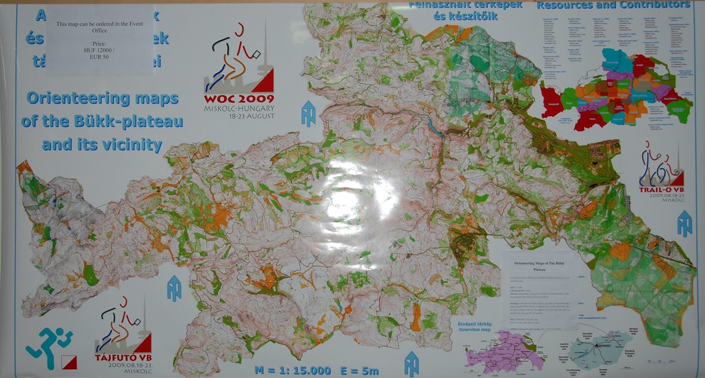
But, this is what I find interesting. While there may be places in Scandinavia like this, are there others in continental Europe? This map suggests the maximum transect of real mapped terrain in Hungary. I'm pretty sure I drew it at least close to correctly.
And, of course, here.
This place is getting there.
French Creek is OK, but I doubt it can compete. (Although there are two different additions slowly coming along which will certainly buttress things, and there is some more mappable terrain there...)
But, this is what I find interesting. While there may be places in Scandinavia like this, are there others in continental Europe? This map suggests the maximum transect of real mapped terrain in Hungary. I'm pretty sure I drew it at least close to correctly.
And, of course, here.
This place is getting there.
Sep 13, 2010 3:49 PM
#
bubo:
Re: ...places in Scandinavia...
I guess the situation in Borlänge is similar to many places in Sweden - so we´re not pretending to be unique. These are just the maps made/owned by Stora Tuna OK - in addition there are several nearby maps made by other clubs. "Only" 25KM long though...
I guess the situation in Borlänge is similar to many places in Sweden - so we´re not pretending to be unique. These are just the maps made/owned by Stora Tuna OK - in addition there are several nearby maps made by other clubs. "Only" 25KM long though...
Sep 13, 2010 7:28 PM
#
@j-man: Yep, this Hungarian map is pretty big... It's printed size (1:15.000) is 185x105 cm inside the frame and it covers approx. 300 square kms of land. There are some parts (~ 10%), that have never been used for orienteering, but the others are 'real' orienteering maps.
The optimized map itself occupies 52 MB of my HDD (OCAD 9 format) and has almost 400.000 objects. I don't want to count, how much time it took to draw all the pieces together :)
The optimized map itself occupies 52 MB of my HDD (OCAD 9 format) and has almost 400.000 objects. I don't want to count, how much time it took to draw all the pieces together :)
This discussion thread is closed.