Discussion: Harriman training over Thanksgiving weekend
in: Orienteering; General
Nov 17, 2018 8:08 PM
#
I'll be in the NYC area next weekend and would love to do some training in Harriman and possibly Blue Mountain. Would anyone like to join me? If there is interest, any day between Thursday-Sunday is a possibility.
Nov 17, 2018 8:57 PM
#
I was going to try go there on Wednesday. Thursday is tricky and Friday I leave NYC.
Nov 17, 2018 10:56 PM
#
Jordan Laughlin told me to try and hook up with you, but I can't make it happen. Family and car rental make it too difficult. Maybe next time. Back at Christmas, But I'm sure it'll be very cold and snow.
Nov 18, 2018 1:58 PM
#
Yeah, there definitely is. And it's pretty slick too, at least over here in the Poconos. Metal studs are very useful.
Nov 18, 2018 5:37 PM
#
Guisborough1, I don’t know if Mt Lakes (location of the Team Trials this past June) would be of interest. On Wednesday, we will be out there putting out streamers for an upcoming local event. You could test run the Red course if you like
Nov 18, 2018 11:25 PM
#
Snow conditions in Harriman (Sunday eve) ; Harriman received about 9 inches of reasonably wet snow. Top of the snow is thin crusty ice. As of Sunday afternoon ,I would say there is 90% snow coverage compacted down to 5 inches. People have been skiing in the park on rock skis. Overcast skies and temps in the low 40's have resulted in minimal melt today. Orienteering today would have been pretty exciting as you broke thru the crust at every step. I'll update what I see during the week. Moderating temperatures and mixed precipitation tomorrow will change conditions. Reach out to me for more details or advice :-).
Nov 19, 2018 9:41 PM
#
Brutally cold temperature is expected in NYC -- 16F, orienteering will be impossible.
From here:
"Brutally Cold Temperatures Threaten To Devastate Black Friday Sales"
www.zerohedge.com/news/2018-11-18/brutally-cold-te...
From here:
"Brutally Cold Temperatures Threaten To Devastate Black Friday Sales"
www.zerohedge.com/news/2018-11-18/brutally-cold-te...
Nov 19, 2018 11:02 PM
#
nielsLO thanks for the offer. I've just tried to book a car from Manhattan to get there and its way too expensive (and there aren't many left!). Really appreciate it. Maybe next time. It's a pity because I was excited after looking at the map.
Nov 20, 2018 3:33 AM
#
Guisborough1. It's possible to take a Metronorth train from Manhattan and we can pick up/drop off from the most convenient station. Email me if your interested. Geof C. went to Mountain Lakes today and reported it to be about an inch of snow and a bit slippery. I suspect some of the snow will melt with the forecasted showers tomorrow morning. Forecast for Wednesday is partly cloudy and low 30s
Nov 20, 2018 12:31 PM
#
I highly recommend orienteering in Connecticut via Metro North. I did that once from Grand Central to West Reading CT and found the O map only a few yards from the West Reading station platform. (actually started the day by riding the LIRR in from Garden City to Penn station and jogging to Grand Central.)
Nov 20, 2018 4:07 PM
#
Thanks gordhun, I may try that at Christmas depending on weather.
Nov 20, 2018 6:32 PM
#
It looks like Thursday and Friday will be near or below freezing, but the expected high Saturday is 48F, and 56F on Sunday. Chance of 0.05" of rain overnight Sat-Sun.
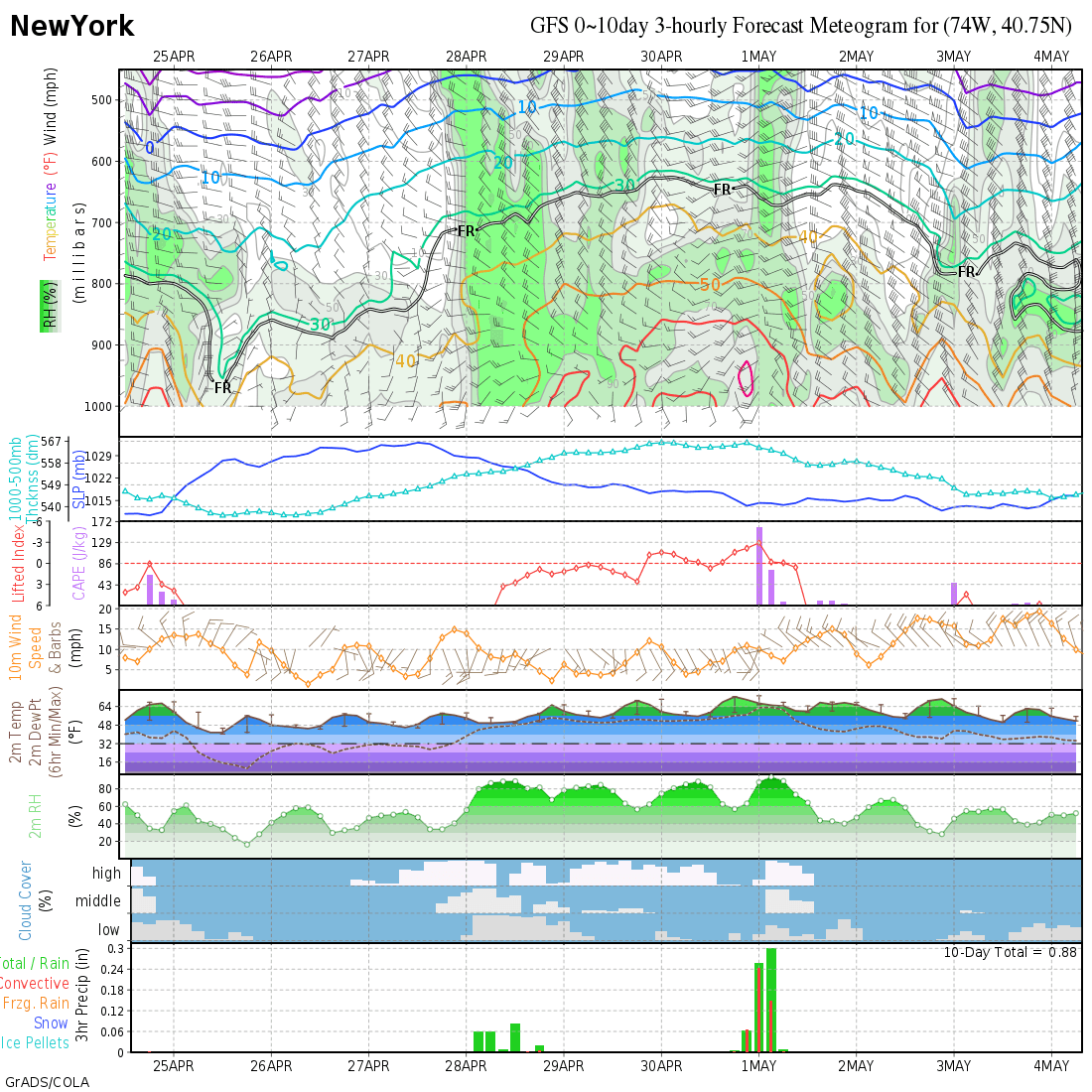
This is a 10-day weather model that I use all the time:
http://wxmaps.org/pix/lgagfs.png (NYC)
Where it has lines for a date (like 24 Nov), that is GMT midnight, so the line for 24 Nov is 7 or 8pm on the 23rd. Look at the 2m Temp line, and the 3-hr precipitation bars at the bottom.
If anyone is interested, here are the 10-day models for selected cities in the US and Canada:
http://wxmaps.org/pix/meteograms
One thing I use a lot in the summer is the Lifted Index (which has an upside-down scale). When the Lifted Index goes negative, there is a chance of pop-up showers. Interestingly, NYC goes to zero Monday around dark in the middle of that big rainstorm.
Finally, it's a model for *weather*. So it's subject to being very, very wrong. The images refresh twice a day around 8am and 8pm eastern time (~noon and midnight GMT). The rain forecast typically changes ("becomes more accurate") three days out. Sometimes it accurately forecasts stuff over a week away, but sometimes it says it won't rain tomorrow and it actually drizzles all day.
Nov 20, 2018 6:56 PM
#
So after all this, the weather does not make it attractive for me to get out on the maps during this visit, so I will stick to snow-free training in the DC area and then a minimal visit to NYC for Saturday-Sunday. Thanks for all the info, everyone!
Nov 23, 2018 12:56 PM
#
We went out on the west edge of Surebridge yesterday. We still have 75%+ snow coverage although the steep south facing slopes near Kanawauke parking were clear. Snow is about 3 inches deep crusty and crunchy. We stuck mostly to trails. Running on the snow was slow since we broke thru the crust at every step.
Temp today is in single digits. Conditions will remain the same thru Saturday although temps will be trending up.
Temp today is in single digits. Conditions will remain the same thru Saturday although temps will be trending up.
Nov 23, 2018 4:49 PM
#
No snow at Ward Pound Ridge and Mountain Lakes. Forecast for tomorrow is partly cloudy 40F, with rain showers late afternoon; Sunday high 40s, partly cloudy.
Nov 26, 2018 1:01 PM
#
3-5 inches of snow and a little cold temps are terrible conditions? I guess Canadians are tougher. otherwise we would never be able to train all winter.
Maybe Canada should host NAOC in winter here and we would win BK Cup by default
Maybe Canada should host NAOC in winter here and we would win BK Cup by default
Nov 26, 2018 1:13 PM
#
Who said anything about terrible conditions? Just unattractive, given the snow-free alternative at home.
Nov 27, 2018 3:11 AM
#
(To be fair, that is how the depth was reported. He may be just repeating it without really understanding what it means.)
Mike, don't you realize that an inch is the distance from your elbow to your fingertips? And in Fahrenheit, 31 degrees is the freezing point of helium.
Mike, don't you realize that an inch is the distance from your elbow to your fingertips? And in Fahrenheit, 31 degrees is the freezing point of helium.
This discussion thread is closed.