Discussion: Straight line leg
in: blairtrewin; blairtrewin > 2017-11-23
Nov 24, 2017 12:32 AM
#
Best I can see around here is 11k on the west Bendigo master map, 11.5 on the east bendigo master map and 6 on the north Bendigo master. Orivate land creates a problem on each.
I can find 6.5 on Kooyoora if you map the reference area. But if you chose the correct line on Kooyoora, I am sure that you could make a longer run than any of the above in terms of time. Not much fun though.
I can find 6.5 on Kooyoora if you map the reference area. But if you chose the correct line on Kooyoora, I am sure that you could make a longer run than any of the above in terms of time. Not much fun though.
Nov 24, 2017 12:58 AM
#
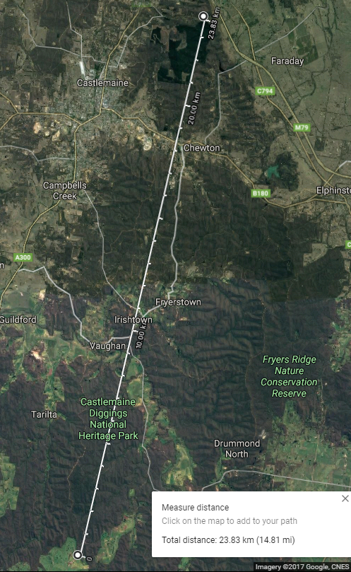
Nearly 24k, all ares are mapped, but do they map to the edge of the main roads
Castlemaine Goldfields, Chewton Diggings, Wattle Gully, Irishtown, Glenluce, Middletons Creek, Porcupine Ridge
Castlemaine Goldfields, Chewton Diggings, Wattle Gully, Irishtown, Glenluce, Middletons Creek, Porcupine Ridge

Nov 24, 2017 3:03 AM
#
Then there's the River Torrens Linear Park mapping project - everything from Port Rd to the hills at Athelstone is now on one OCAD file I believe.
Nov 24, 2017 4:06 AM
#
WE could give you Kalamunda National Park to John Forrest National Park via Gooseberry Hill and Greenmount - only 15km but would most likely take you longer than the Castlemaine leg. Very steep, very rocky, very thick.
Nov 24, 2017 5:04 AM
#
the string of maps on the eastern side of the Sugarloaf Range near Newcastle, from ODonneltown/Sugarloaf south to The Lot/Sandy Creek/Hawkemount, covers about 20km, but also includes some mapped but unused areas like the M1 motorway, the Sugarloaf escarpment, and possibly a cemetery/crematorium right on the critical path. Straight line would not be the way to do it either!
Nov 24, 2017 11:30 AM
#
There is indeed a small gap in Chewton between the railway (northern boundary of Wattle Gully) and the road (southern boundary of Castlemaine Goldfields), though Kathy Liley pointed out at tonight's Yarra valley meeting that that is on an MTBO map.
This discussion thread is closed.