Discussion: Best cities for orienteering (and why)
in: Orienteering; General
Apr 1, 2017 5:02 PM
#
rm:
I'm curious to hear thoughts about which cities on each continent are best for orienteering.
Points for:
*Limited driving to get to orienteering (how close)
*Variety of great terrain
*Good orienteering community
*Good schedule of events (locally, in neighboring cities, and further but feasible for a weekend event)
*Feasible to train frequently on maps
*Long season; feasible to train or compete much of the year
*Decent competitive field
Obviously this was inspired by the trail running cities thread, but it seemed like an interesting topic for orienteering as well. Some general locations worldwide seem obvious, but within each continent I'm not so sure; perhaps there are interesting insights, hidden gems, non-obvious opportunities.
Apr 1, 2017 7:11 PM
#
In North America:
If you like sprints: Vancouver, BC
If you have kids: Hamilton, ON
If you enjoy small crowds: Laramie, WY
If you like sprints: Vancouver, BC
If you have kids: Hamilton, ON
If you enjoy small crowds: Laramie, WY
Apr 1, 2017 9:35 PM
#
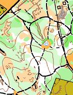
I think Ottawa absolutely has to be mentioned here. Is there any other city in North America with as many technical forest maps easily reachable by bus or bike from downtown? The variety is quite good, too - just take a look at a few maps:
http://orienteering.ca/cgi-bin/reitti.pl?act=map&a...
http://orienteering.ca/cgi-bin/reitti.pl?act=map&a... (not within biking distance)
http://www.sprintseries.org/doma/show_map.php?user... (not within biking distance)
http://orienteering.ca/cgi-bin/reitti.pl?act=map&a...
http://orienteering.ca/cgi-bin/reitti.pl?act=map&a...
http://www.dxdeluxe.se/linnekartparmen/show_map.ph... (not within biking distance)
http://orienteering.ca/cgi-bin/reitti.pl?act=map&a...
http://orienteering.ca/cgi-bin/reitti.pl?act=map&a...
http://orienteering.ca/cgi-bin/reitti.pl?act=map&a...
http://orienteering.ca/cgi-bin/reitti.pl?act=map&a... (not within biking distance)
There are also many park and urban maps. Hamilton may be better for kids (although Ottawa has a strong kids program, too), but Ottawa has a better balance between kids and adults, in my view. In addition to weekly Sunday events in spring and fall, there are also weekly training sessions for adults at all levels, as well as occasional mapping and event official training courses. A very friendly club, many enthusiastic people, no lack of volunteers for events. Some very good orienteers including senior and junior national team members Eric Kemp, Alex Bergstrom, Robbie Graham; people originally from Ottawa like Emily Kemp, Robbie Anderson and Jon Torrance still visit regularly and compete in local events. Also many good orienteers in older age categories, as well as promising juniors.
http://orienteering.ca/cgi-bin/reitti.pl?act=map&a...
http://orienteering.ca/cgi-bin/reitti.pl?act=map&a... (not within biking distance)
http://www.sprintseries.org/doma/show_map.php?user... (not within biking distance)
http://orienteering.ca/cgi-bin/reitti.pl?act=map&a...
http://orienteering.ca/cgi-bin/reitti.pl?act=map&a...
http://www.dxdeluxe.se/linnekartparmen/show_map.ph... (not within biking distance)
http://orienteering.ca/cgi-bin/reitti.pl?act=map&a...
http://orienteering.ca/cgi-bin/reitti.pl?act=map&a...
http://orienteering.ca/cgi-bin/reitti.pl?act=map&a...
http://orienteering.ca/cgi-bin/reitti.pl?act=map&a... (not within biking distance)
There are also many park and urban maps. Hamilton may be better for kids (although Ottawa has a strong kids program, too), but Ottawa has a better balance between kids and adults, in my view. In addition to weekly Sunday events in spring and fall, there are also weekly training sessions for adults at all levels, as well as occasional mapping and event official training courses. A very friendly club, many enthusiastic people, no lack of volunteers for events. Some very good orienteers including senior and junior national team members Eric Kemp, Alex Bergstrom, Robbie Graham; people originally from Ottawa like Emily Kemp, Robbie Anderson and Jon Torrance still visit regularly and compete in local events. Also many good orienteers in older age categories, as well as promising juniors.
Apr 2, 2017 1:41 AM
#
Oklahoma City, due to its strategical central location --- the rest of the country is just a few hrs of driving, well, maybe except South Florida
Apr 2, 2017 11:41 AM
#
St Louis because of those beautiful white woods and ridge-and-valley terrain of the nearby Ozarks. Plus a small club of dedicated and congenial orienteers. Plus its proximity to other O strongholds in KC, OCIN, NEOOC, SMOC, BGR and CAOC...not to mention striking distance of O clubs throughout the South.
Housing is inexpensive and the city has many attractive features and neighborhoods. And a climate that permits O training year around. The only drawback might be that when you're out in the Ozarks, you gotta watch for moonshiners and Deliverance-type scenarios. :-)
Housing is inexpensive and the city has many attractive features and neighborhoods. And a climate that permits O training year around. The only drawback might be that when you're out in the Ozarks, you gotta watch for moonshiners and Deliverance-type scenarios. :-)
Apr 2, 2017 10:16 PM
#
Need I say it again? Uppsala.
Oh, why? I super active club with multiple trainings, woods and trails, each week, Surrounded by excellent forest, all mapped superbly, and all of it a 10 minute by car, 20 minute by bike or public transport from anywhere in the city.....
and Boston is still pretty good, all the maps are still there, and quite a few orienteers, and sometimes weekly trainings.
Apr 2, 2017 11:35 PM
#
You need a different yardstick for Sweden. For me, midweek training in the dark at -20C isn't all that appetising. Or later on in spring breaking through ice into slush regularly is less than enticing.
Apr 3, 2017 12:03 AM
#
Rochester is pretty good with lots of small city parks for newcomers and Mendon Ponds and Letchworth nearby. Not Ottawa, but not bad.
Apr 3, 2017 1:11 AM
#
I have been watching the North American competition. It made me think its not too bad in this part of Australia.
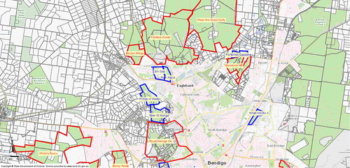
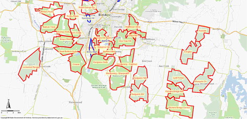
Thats 26 forest maps on the edge of town to 10 minutes drive. They are a mix of gold mining and spur gully. Drive for 15-20 minutes and you find another 11 forest maps. If you are prepared to drive 30 minutes you can reach highly technical terrain like Kooyoora. That's 250 square kilometres of mapped terrain. It never snows. It does get hot in summer but you can still run in the morning. No bears. Events every week from March to October.
Thats 26 forest maps on the edge of town to 10 minutes drive. They are a mix of gold mining and spur gully. Drive for 15-20 minutes and you find another 11 forest maps. If you are prepared to drive 30 minutes you can reach highly technical terrain like Kooyoora. That's 250 square kilometres of mapped terrain. It never snows. It does get hot in summer but you can still run in the morning. No bears. Events every week from March to October.
Apr 3, 2017 3:01 AM
#
rm:
How did your club(s) achieve so much mapped terrain? Professional or volunteer mapping? How many club members? How many participants in events?
Apr 3, 2017 3:55 AM
#
The terrain is luck.
The maps are a mix of professional and volunteer over the past 40 years. Getting access to good lidar coverage has really helped.
160 members by end of each season.
Average event attendance between 60-70.
The maps are a mix of professional and volunteer over the past 40 years. Getting access to good lidar coverage has really helped.
160 members by end of each season.
Average event attendance between 60-70.
Apr 3, 2017 12:13 PM
#
How's land access too? Is it through government associated owners or private? (I'm jealous :) )
Apr 4, 2017 12:19 AM
#
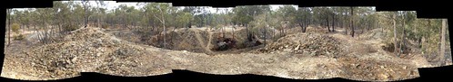
It's almost all public land, probably a legacy of the fact that in general the miners got there before the farmers did (much of the area is covered to a greater or lesser extent by old mine workings from gold rushes from the 1850s onwards). One of the locals may want to comment more on the history - my assumption is that the area was largely deforested during the gold-rush era and then regrew through the 20th century after mining largely finished.
I'm sure TheInvisibleLog will comment further, but my understanding is that in the Bendigo area, although the bureaucracy involved in land access is not getting any easier (and there was a bit of an unfortunate misunderstanding last year involving a double-booking with a shooting group), we can usually get into the areas we want to. It's more difficult in some other parts of the country.
I'm sure TheInvisibleLog will comment further, but my understanding is that in the Bendigo area, although the bureaucracy involved in land access is not getting any easier (and there was a bit of an unfortunate misunderstanding last year involving a double-booking with a shooting group), we can usually get into the areas we want to. It's more difficult in some other parts of the country.
Apr 4, 2017 1:06 AM
#
There is a reason why the largest hill is named "One Tree Hill", though its covered with forest today.
Apr 4, 2017 1:13 AM
#
Yep that's one thing we have to thank the miners for (other than the creation of the mining towns in the area). Even though they took all the gold away, there are now some great orienteering areas in our country. We don't have any of that on the west coast; just a whole bunch of granite.
Apr 4, 2017 1:45 AM
#
rm:
The Canadian province of British Columbia has mining to thank for a town amidst a high concentration of orienteering maps of great terrain. I heard a Canadian orienteer muse about waiting for low copper prices to buy a home to retire there.
Oddly enough, my county has both gold mining (more gold produced than the Californian and Alaskan gold rushes combined) and orienteering maps of great terrain (despite only one active orienteer). (And granite.) Maybe there's a correlation between gold mining and orienteering terrain; haven't calculated it.
Oddly enough, my county has both gold mining (more gold produced than the Californian and Alaskan gold rushes combined) and orienteering maps of great terrain (despite only one active orienteer). (And granite.) Maybe there's a correlation between gold mining and orienteering terrain; haven't calculated it.
Apr 4, 2017 1:57 AM
#
I remember when there were two orienteers in that county. And neither one was you.
Apr 4, 2017 2:43 AM
#
rm:
Well, there are other orienteers, just not active (both in my search and rescue unit). And the local club's map of maps still calls part of it Center of the O Universe. (The two orienteers that you remember have moved north for retirement, as you may know.)
Apr 4, 2017 3:12 AM
#
You tend to take your riches for granted. This weekend is the first use of a new orienteering map. It is located on the fringes of the town. And its just a local event. It has taken the club 40 years to get round to mapping it. Well, it took the club 40 years until I got sick of waiting.
There are still a few areas remaining unmapped and close to town, but they are pretty bland.
There are still a few areas remaining unmapped and close to town, but they are pretty bland.
Apr 4, 2017 6:33 AM
#
Edinburgh
3 clubs in the city
Weekly training with a club during the week
Loads of maps
Your in the central belt so events at weekends that can cycle to or bus/train or carpool.
Pentlands are just there as well for your terrain/hill runs.
3 clubs in the city
Weekly training with a club during the week
Loads of maps
Your in the central belt so events at weekends that can cycle to or bus/train or carpool.
Pentlands are just there as well for your terrain/hill runs.
Apr 4, 2017 10:51 AM
#
You go south for the winter, not retirement.
You apparently don't have Florida (or Arizona) in Australia.
You apparently don't have Florida (or Arizona) in Australia.
Apr 4, 2017 4:36 PM
#
Boston has potential. I like it, but I live here.
Pros:
- international airport
- 1.5h drive gets you to some really cool forested maps
- decent number of sprint maps within the I-95 corridor, mostly accessible by transit
- large urban forest (Middlesex Fells) map accessible by transit
- three clubs, each with a slightly different target audience (Navigation Games, CSU, NEOC)
- Weekday training by club members
- lots of universities if you're of that age, some quite good
- lots of running clubs/fitness groups/young people
- nordic skiing on manmade snow with lights
- good proximity to northeastern National Events
Cons
- traffic
- cost of living (#6 in the US according to this)
- Snow sometimes prohibits winter training
- Summers are unpleasantly hot
- Summer vegetation sucks
- really need a car if you actually want to train on all the maps
- land access - DCR won't allow off-trail use for about half of both our major urban parks (Middlesex Fells, Blue Hills)
- many of the forest maps are out of date, with no real institutional desire to update them
- the drivers are terrible
- traffic
Apr 4, 2017 5:27 PM
#
rm:
Having orienteered near Boston for two decades, I'll challenge the assertion that summer vegetation all sucks. Some of the vegetation does suck, badly, and there are mosquitoes. But some parts of the forests can be lovely in summer (yes, really, having organized a couple of summer events and done map scouting and running in summer). Unfortunately, it isn't a simple matter of looking at the terrain in spring or fall and mentally adjusting for thicker veg. Some forest gets much thicker, some not at all, or barely. You have to look at the terrain in the summer to see where is open and where is thick.
Has the entire Middlesex Fells been mapped now, at least for training? There's enough for a few maps.
Sad to hear about the maps getting out of date. When I was last there, NEOC had fifty color maps (more or less ISOM), some small but some quite big, and most of it quite good terrain.
The driving is terrible.
Apr 4, 2017 9:38 PM
#
Canada's top 5 list is pretty easy and I'm sure most would agree that they are (from west to east):
Whitehorse, Vancouver, Calgary, Hamilton, Ottawa.
Of those five I'm sure most Canadians would agree that Whitehorse is by far the best place to O in Canada. Sure there is a shorter race season and you have a long way to travel to big races (though NAOC is there next year) but the terrain and maps are excellent.
Fun fact: The percentage of 2016 Team Canada athletes originally from those five towns, currently living in them and/or are members of the clubs from those towns is: JWOC (100%), WUOC (100%), WOC (75%).
A few years ago I was involved in a discussion on where Orienteering Canada should develop National Training Centres (part of their strategic plan). The NTCs would ideally be in University town and have good proximity to maps, weekly training, coaches, coaching job opportunities, driving distance to out-of-town races, and a good balance of XC skiing training opportunities and also snow-free woods for winter training. All but Whitehorse of the top 5 listed above are University towns.
My club (DontGetLost) put in a proposal to host the Eastern NTC in Hamilton because we have a top ranked university, many maps, weekly year-round training, within driving distance to many NE US races, a few full time employees and student job opps with Canada's largest kids O program. Sadly, there wasn't enough interest at the time among the few athletes of University age so we pulled our proposal. But if I was tasked to choose the best location for a NTC today I'd rank them Vancouver, Ottawa, Hamilton, Calgary.
I maybe would have ranked Ottawa higher but their NHL team sucks. No seriously they do. ;-)
Apr 5, 2017 4:39 AM
#
You apparently don't have Florida (or Arizona) in Australia.
We also don't have a south in Australia (notice I made my comment so it was easy to understand for you northerners).
We also don't have a south in Australia (notice I made my comment so it was easy to understand for you northerners).
Apr 5, 2017 4:56 AM
#
tRicky is a West Australian. Traditionally West Australians like to believe there is no South Australia, just an impassable void between Perth and the eastern states. I suppose the closest those in the US have is the concept of flyover states.
Apr 5, 2017 5:08 AM
#
Problems with land access for orienteering and other outdoor activities in America are due to its capitalism. Political regime serves the Greedy Wall Street banksters who rule the country, and who do not want poor people to enter their property. In places like Texas and Oklahoma,in lots of other places, its perfectly legal to shot to kill a "trespasser". They view countries like Finland and Norway as being ruled by "commies", and look at them with contempt.
But the "green nazis" in Massachusetts and California are even worse.
I recall in old Soviet days you could get access to practically anywhere, just give a small bribe to whoever was in charge for granting it, a bottle of vodka will do.
But the "green nazis" in Massachusetts and California are even worse.
I recall in old Soviet days you could get access to practically anywhere, just give a small bribe to whoever was in charge for granting it, a bottle of vodka will do.
Apr 5, 2017 5:16 AM
#
rm:
Actually, looking from the air, the homes of the middle class take up far more of the land around cities than the land of the very wealthy. It's a bit of a problem of mass wealth.
Apr 5, 2017 12:31 PM
#
Based on the No Trespassing signs I've seen, poor people in the US are every bit as opposed to anybody stepping on their land as rich people are. The most such signs I've ever seen were in rural West Virginia. My understanding is that there wasn't even any concept of land ownership here until the Europeans arrived, kind of ironic. But permission problems exist on publicly owned land as well, due to a number of factors, among them underfunding for the parks, requiring them to charge exorbitant permit fees.
Apr 5, 2017 3:45 PM
#
rm:
Given that the land that we're using is worth a lot of money, especially if located anywhere near the city, the permit fees don't seem so exorbitant. (The land that's too steep or wet to be developed is also too steep or wet for orienteering mostly, and so the land that we use is at least potentially developable, and thus worth a lot per acre/hectare.). We're fortunate to have many millions of acres available, preserved by the federal, state or local government, or private organizations. What limits close in orienteering is the nature of our cities, with so many single family homes filling the space, as well as the sometimes realistic fear by city park managers that off trail use will damage the terrain (or has been, quite significantly, in the case of Colorado Springs, where several areas of the parks are denuded by hikers and bikers going every which way, also making myriad random trails, and sometimes lighting a roaring campfire in a hollow amidst the brush). The more people use an area, the more restrictions typically, it seems to me.
Given the constraints of each locale, how can the most orienteering be had?
Given the constraints of each locale, how can the most orienteering be had?
Apr 5, 2017 8:09 PM
#
This thread has wandered far away from the original topic and I'm not going to help get it back on track but somehow we got on to the topic of land access or lack of it.
These past few months I worked with a state agency here in Florida to get orienteering allowed as a new activity on one of their lands. It was interesting as my contact shared with me the e-mails between their various departments as they all weighed in on their particular concerns. I intend to write an article for ONA about the process. Suffice it to say for now that it is interesting to see orienteering from the view of someone charged with protecting sensitive habitat. It is better to answer and work with those concerns rather than fight them head on.
One other observation: when seeking permission from an agency it helps to do some research, find out what the agency's goals are and frame your request in a way that meets their goals. This from Florida State Parks: "The goal of the Florida Park Service is to help create a sense of place by showing park visitors the best of Florida's diverse natural and cultural sites. Florida's state parks are managed and preserved for enjoyment by this and future generations through providing appropriate resource-based recreational opportunities, interpretation and education that help visitors connect to ...the Real Florida"
BINGO! There is no more 'appropriate resource-based recreational opportunity' than orienteering.
Apr 9, 2017 7:22 PM
#
In Norway I would have to vote for either Halden or Kristiansand due to the year-round requirement, probably not coincidentally those two cities are responsible for (almost?) all Tiomila and Jukola wins by Norwegian clubs.
For great terrain and maps however my favorite city is Kongsberg, and both NOF and IOF agreed since they put the very first WOC in Norway there in 1978.
Kongsberg, just like Oslo also have good xc skiing in wintertime, something I consider a big plus, but I normally get at least one (night) race every month during winter.
This discussion thread is closed.