Discussion: Incorrect controls
in: Prendy; Prendy > 2017-03-05
Mar 5, 2017 12:03 PM
#
I should know, but am interested to know the ones you thought were incorrect.
Mar 5, 2017 12:06 PM
#
No 126 and something very odd about 108. Not far from where they should be but enough to cause problems
Mar 5, 2017 12:30 PM
#
Didn't notice the problem with 108, as it was clearly visible, but lost heaps of time on 126, despite heading off the track junction to exactly that point. Couldn't understand what was wrong and then headed further west, in the wrong direction. The opposition caught me up here. Glad you explained it.
Mar 6, 2017 12:30 AM
#
I had trouble with 108, but concede that this was mainly my own fault. Lets just say I came down the gully from above and it was in the gully. I found 139 a little confusing as it seemed to be a fair bit further down the hill than the 2 metres indicated by the contours. The circle was lower down than the hill than the feature. The circle centre was probably pretty close to the control location. Map issue. I can say this because my event the day before revealed a map issue that was the fault of my mapping.
Mar 6, 2017 12:32 AM
#
There is a question about State Series and Relays that probably deserves a considered decision by the sport as a whole. Are these forest events, or does the State Series encompass all forms of orienteering?.
Mar 6, 2017 1:28 AM
#
None of the above Invis. Control was at the base of the large cliff 50m to east of the control
Mar 6, 2017 2:05 AM
#
That's what I thought. Unfortunately I searched west. But doesn't matter. Re Invis's comment - I'm a bit over park events that have controls hidden in places you need to do gymnastics to get to. Prefer forest events. I haven't enjoyed a relay since the one at Eppalock.
Mar 6, 2017 4:34 AM
#
Are we talking 126? I came to it from the east - we had a control higher up the spur - and I didn't want to go to 126 from the top, so dropped onto the river trail, went under the big cliff, then climbed to 126, right were I expected it to be
Mar 6, 2017 7:53 AM
#
Maybe it was the track junction that was out. I think l'll have to back and investigate.
Mar 6, 2017 7:54 AM
#
I think we are talking about different controls. My comment was 139. There is no cliff to the east of that one. Well not mapped anyway. I didn't go to 126, being on course 3.
Mar 6, 2017 8:01 AM
#
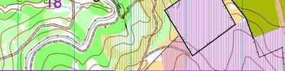
Re venue for relays- the profile for a forest relay in the IOF rules makes it clear that limited visibility is important to reduce following. Victoria has generally ignored that. I would like the relay to be on a map like New St Mungo- lots of tracks, low visibility, mining features. I will be running the Bendigo "relay" on it this year unless the wind inside the forest exceed 20kph, in which case I won't run the event or time it, but am happy to pass around maps to those interested. Here is the current version of the map.
Mar 6, 2017 8:34 AM
#
Complaint 2 from a grumpy old woman. Why does DOMA no longer work on either my phone or my computer? Any ideas?
Mar 6, 2017 9:48 AM
#
If it was routegadget I would understand. I thought DOMA was pretty bullet proof.
Mar 6, 2017 10:26 AM
#
By nuffink do you mean its doesn't even give you the url at the top of the screen? Or do you get the web page but no map? Louise probably understands better than I...
Mar 6, 2017 10:41 AM
#
I am sure it is my settings. I haven't been able to get Bruce's winning route choices for ages.
My first tab says http://doma.orienteering.asn.au/show_map.php?user=... target= (no, it doesn't say that - can't even paste it correctly).
My second tab says 'doma.orienteering.asn.au', but with a blank page. My phone says the same.
Oh where are the smart teenagers when you need them?
My first tab says http://doma.orienteering.asn.au/show_map.php?user=... target= (no, it doesn't say that - can't even paste it correctly).
My second tab says 'doma.orienteering.asn.au', but with a blank page. My phone says the same.
Oh where are the smart teenagers when you need them?
Mar 6, 2017 11:30 AM
#
I've had the same problems viewing people's maps for a couple of weeks also, whether from work or home, computer or laptop...but this week AP keeps on logging me out as well.
Mar 6, 2017 12:01 PM
#
Aha. Me too. I thought it was because l loaded a new version of Google on my phone.
Mar 6, 2017 10:30 PM
#
I went out and had another look at the controls in question this morning.
126 is definitely on the right cliff - the big curved cliff is about 20 metres to the east, and is unmistakeable. However, the cliff is mapped a contour or two too far up the slope (and in general the contours don't make it particularly clear where the transition from gentle to steep slope, which is clear on the ground, is). It's also possible that it might be misaligned with respect to features that one might use to attack it from above.
At 108 the issue is that the gully doesn't extend as high on the ground as it does on the map. I moved this one when I checked in the morning (it was originally in the wrong gully). I put it as high in the gully as I could whilst still having it in a discernable feature, but I think it was probably still a contour or two too low.
Mar 7, 2017 1:47 AM
#
Good detective work :)
In SA a number of years ago we moved to a 2-person relay format, where each person runs twice but the courses are shorter, to make it easier for clubs to find willing participants and form teams.
More recently, since the Arrows took over organising, we've alternated between using urban sprint and forest venues on a biennial basis, although we haven't yet aligned these with future split WOC years...
Mar 7, 2017 5:14 AM
#
The issues described would be consistent with those controls being easier to find from below rather than from above. When approaching 108 from above the frame was a good attackpoint, but the control seemed to be NW of where it was marked, and for 126 it seemed to be east of where it was relative to the track junction. 108 was easy to see from the lake side, and 126 would have been easier to see from below.
Mar 7, 2017 8:07 AM
#
Keep it coming. A few more and we will get the taciturn Roch at the top of the Noisy logs list.
This discussion thread is closed.