Discussion: Neat and unique orienteering control locations
in: Orienteering; Off-Course
Apr 12, 2015 8:25 PM
#
Because of some unique control locations at the 2015 Flying Pig and US Team Trials this year, we thought we'd start a thread.
Please link or embed your own photos of unique sites.
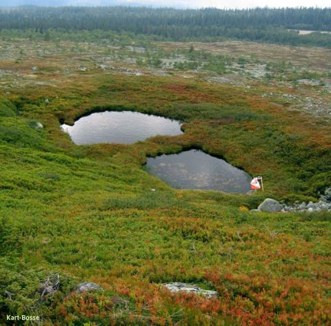
Here's Middle course control #33, depression. The water running was audible as you approached the depression. Click photo for larger view, and subsequent close-up.
Please link or embed your own photos of unique sites.
Here's Middle course control #33, depression. The water running was audible as you approached the depression. Click photo for larger view, and subsequent close-up.
 |
| From Neat O control locations |
Apr 12, 2015 9:20 PM
#
It's mapped as a depression. In the terrain it looks like a depression with a rocky pit at its center, but mapping both would clutter the map. I guess for extreme overmapping, you could add a small line of blue in the middle. :-)
Apr 12, 2015 9:23 PM
#
The viewpoint of the photographer is looking downhill, rather than into the hillside. I'm standing at the edge of the wider depression.
Apr 12, 2015 10:13 PM
#
The US Federal Cave Protection Act of 1988 forbids creating maps showing cave locations.
Apr 12, 2015 11:48 PM
#
That applies ony to "significant" caves (I don't know if that one would qualify), and I think only on Federal lands.
Apr 12, 2015 11:50 PM
#
Granted I have not been there in person to check it out, but wouldn't it make sense from a safety point of view to map it as a black 'V'?
Apr 13, 2015 12:24 AM
#
We debated that. At one point I changed the depression (contour line depression as mapped originally by Zherdev) to a black V, which we had universally used for dangerous pits. The course setter protested that the depression was significantly larger than other pits and cup depressions mapped nearby, and that it would have been deceptive to show as a V because of the size. We agreed that we couldn't clutter the map to show both. So, I redrew the contour line depression, but insisted that the opening be heavily streamed and specified where to place the stand, safely away from the opening.
A good exercise / discussion in how to map without overcrowding.
A good exercise / discussion in how to map without overcrowding.
Apr 13, 2015 12:27 AM
#
The vertical boulder leaving against a tree is another cool one. Did anyone get a picture of that one?
Apr 13, 2015 12:55 AM
#
"Cave" is a reasonably routine control description on Australian maps (mostly in Victoria) which cover old mine workings from various 19th century gold rushes, but the "caves" in question are almost always old mineshafts dug horizontally into hillsides.
Apr 13, 2015 1:40 AM
#
bl:
Maybe there should be a flag in the picture? These are close by West Point and Harriman flags in years past:
1 and 2
Always behind the next boulder here Ward Pound Ridge, Westchester
This does fit the description: 3. Moreau in NY as I recall.
Always a nice CP default photo op US Military Academy
1 and 2
Always behind the next boulder here Ward Pound Ridge, Westchester
This does fit the description: 3. Moreau in NY as I recall.
Always a nice CP default photo op US Military Academy

Apr 13, 2015 2:47 AM
#
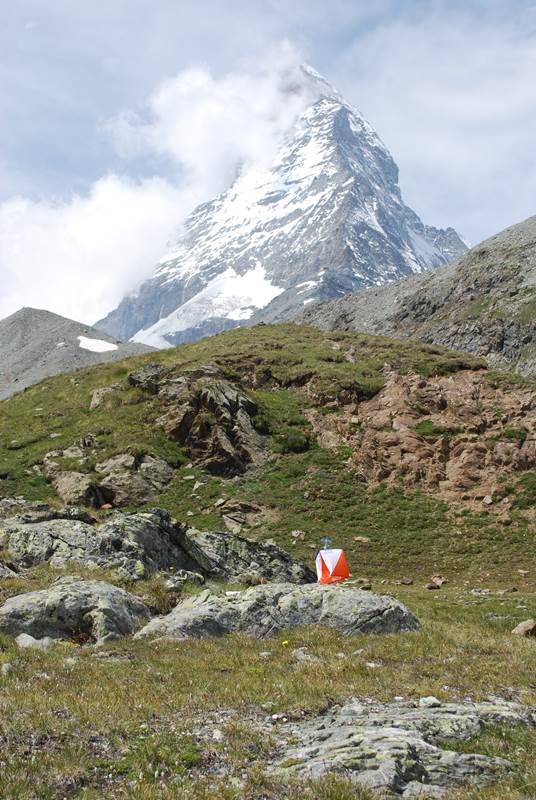
Hopewell is certainly up there (one could even say "it rocks"). Swiss O week in Zermatt. The sprints at Niagara Falls Goat Island a couple years ago with controls at the top of both the American and Horseshoe (Canadian) Falls. A couple cool locations in past Golden Gate Sprints as well.
Apr 13, 2015 3:01 AM
#
Apr 13, 2015 5:51 PM
#
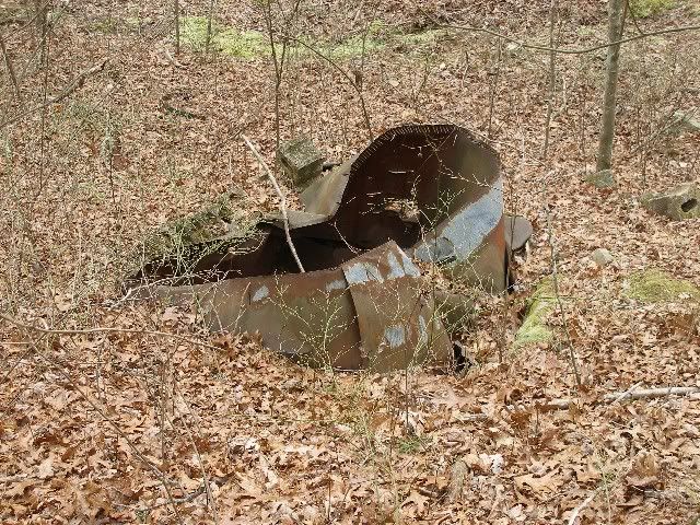
At our recent score-O training event there were bonus points for visiting all 5 car-wreck controls. The partially submerged one was not a control.
https://www.flickr.com/photos/132448499@N08/sets/7...
https://www.flickr.com/photos/132448499@N08/sets/7...
Apr 14, 2015 7:19 PM
#
Oh my god. It is the sprint master j-man, en route to a crushing victory over yet another hapless field of contenders assembled to challenge him. As if.
It's hard to detect the carnage from this photo, but by this point in the race he has already run over 3 pedestrians who foolishly refused to look up from their stupid phones ("served them right"), and he has also run through a chain link fence reinforced with massive mortar blocks ("they called *that" uncrossable?!"). A man not to be trifled with, for sure.
It's hard to detect the carnage from this photo, but by this point in the race he has already run over 3 pedestrians who foolishly refused to look up from their stupid phones ("served them right"), and he has also run through a chain link fence reinforced with massive mortar blocks ("they called *that" uncrossable?!"). A man not to be trifled with, for sure.
Apr 15, 2015 12:16 AM
#
"Sculpture by the Sea" is an annual open-air exhibition along the clifftops between Bondi & Tamara - in 2009 the temptation for a spot of O-bombing got the better of me:
Apr 15, 2015 3:16 AM
#
mbo:
I don't have a photo, but does anyone remember the large (wooden) grizzly bear which was the last control in the World Masters Final near Edmonton in 2005?
Apr 15, 2015 6:02 AM
#
jj, all of the scultures (more than 120) had a catalogue number on a small plaque, and the catalogue had a map showing locations - all of the requirements for a O event.
Incidently artist's application to exhibit closes today (15th April) and the exhibition in Sydney will be open from 22 October to 8 November if one of the local clubs wants to "not organise" a fun event.
Incidently artist's application to exhibit closes today (15th April) and the exhibition in Sydney will be open from 22 October to 8 November if one of the local clubs wants to "not organise" a fun event.
Apr 15, 2015 12:59 PM
#
VJ:
Don't have a photo, or know if it's still there, but I used a bank safe as a control site in a wood in Cork. It had been brought into the wood to blow it open.


Apr 17, 2015 12:14 PM
#
@InvisibleLog...the control description for the boulder control would have gotten my attention!
Apr 17, 2015 2:54 PM
#
I'll try to look up some real photos, but I've set some really nice "tourist controls" at Salmon La Sac, one of which was atop a giant slab of rock with a view kinda like this (hopefully it'll work if you're using the new Google Maps).
The most spectacular control location of recent memory was one of Peteris' "homebrew" races a few months ago, which had a control on a manmade item --a chair-- which was stop a cliff overlooking the Columbia gorge, something like this (the best view is to the northwest, though).
But the most spectacular control locations were at one of the Sprint the Golden Gate weekends, with a Friday evening course running at Point Bonita (here) as the sun was setting on the Pacific.
Apr 17, 2015 4:53 PM
#
I don't have any photographs of the following two Delaware Valley Orienteering Association (DVOA) control locations, but they were certainly unique.
(q.v. Notes from the Briar Patch, March 2003, pp. 8-9)
"... Those on the long course at one French Creek [West] event will remember that famous "water stop," the Surreal Cafe, that she [Anne Fitch] cooked up with Matt Marcinek in the middle of a ruin - a table set with tablecloth, fine china and candelabra. ..."
At Valley Forge Fatlands, there was a control hung inside a large, hollow tree with room to spare for about six orienteers.
Apr 17, 2015 6:09 PM
#
A view of icebergs from the Kangia Icefjord near Ilulissatt, Greenland
Apr 17, 2015 6:13 PM
#
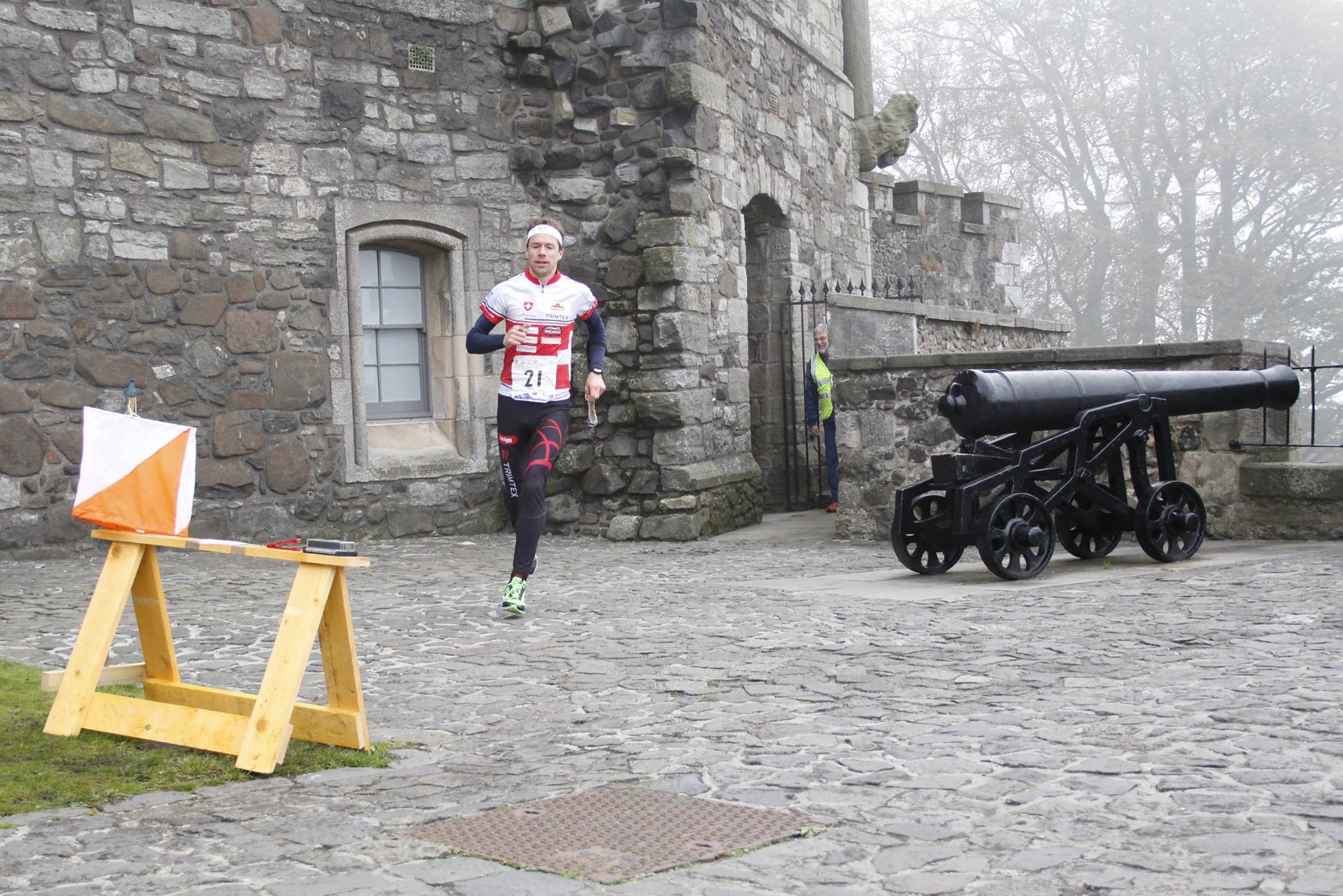
I didn't take a photo at the time, but a cannon from Crimean War, in front of Ely Catherdral, was used as a control at a low key urban evening event in Cambridgeshire, West Anglia Orienteering Club - photo here: http://www.ely.org.uk/cannon.htm
Pretty impressive and unique, I reckon.
Pretty impressive and unique, I reckon.
Apr 18, 2015 5:22 PM
#
One of the most scenic control locations I've ever seen was in the San Francisco Presidio, above the Golden Gate National Cemetary. It looked out over the rows of crosses in the military cemetary, with the Golden Gate Bridge in the background.
Apr 19, 2015 3:59 AM
#
So, when I arrive on one of these "breathtaking" control locations, am I supposed to take a couple of minutes to appreciate the scenery, take a few photos, maybe update also my status at Facebook, right?
Apr 19, 2015 10:13 AM
#
Make sure you phone someone to tell them what you're doing.
Seriously, the number of people I hear on phones telling their listening party that they're "walking down the stairs" is mind blowing. My mind is blown just thinking about it.
Seriously, the number of people I hear on phones telling their listening party that they're "walking down the stairs" is mind blowing. My mind is blown just thinking about it.

This discussion thread is closed.