Discussion: Spectating from a distance at the Flying Pig
in: Flying Pig XIX - U.S. Individual Champs - Sprint-Middle-Long (Mar 27–29, 2015 - Olive Hill, KY, US)
Mar 27, 2015 7:27 PM
#
barb:
Hi - I would love to hear any updates that you all could send from the meet this weekend. I'm happy to receive and post text messages; send to 617-335-4847.
Mar 28, 2015 12:40 AM
#
Mar 28, 2015 1:25 PM
#
Thanks, Valerie, doing like Barb, spectating from afar. But I would not call it spectating, my heart is pounding for my boys and my fingers are stiff from keeping them crossed for them ;)
Mar 28, 2015 7:31 PM
#
M21 (totally unofficial)
1. Damien 92:12
2. Sergei R 94:42
3. Eric 97:30
4. Giacomo 98:26
5. Greg 98:58
6. Zhyk 101:11
7. Will E 104:17
8. Kenny 104:26
9. Jordan 106:27
10. Jourdan 108:10
1. Damien 92:12
2. Sergei R 94:42
3. Eric 97:30
4. Giacomo 98:26
5. Greg 98:58
6. Zhyk 101:11
7. Will E 104:17
8. Kenny 104:26
9. Jordan 106:27
10. Jourdan 108:10
Mar 28, 2015 7:33 PM
#
F21 (totally unofficial)
1. Ali 81:51
2. Amber 90:47
3. Kseniya 92:13
4. Alison 92:45
5. Tori 94:35
6. Alex 95:14
7. Emma 98:17
8. Becky 99:20
1. Ali 81:51
2. Amber 90:47
3. Kseniya 92:13
4. Alison 92:45
5. Tori 94:35
6. Alex 95:14
7. Emma 98:17
8. Becky 99:20
Mar 28, 2015 7:36 PM
#
M20 (totally unofficial)
1. Morten 71:20
2. Michael L 78:08
3. Alex (Canadian) 82:48
4. Matej 85:22
5. Michael S (Canadian) 88:43
6. Will H 90:34
7. Robbie (Canadian) 91:38
8. Austin 91:48
9. Addison 97:13
10. Nakai 102:15
11. Chase 102:53
12. Peter Z 103:22
1. Morten 71:20
2. Michael L 78:08
3. Alex (Canadian) 82:48
4. Matej 85:22
5. Michael S (Canadian) 88:43
6. Will H 90:34
7. Robbie (Canadian) 91:38
8. Austin 91:48
9. Addison 97:13
10. Nakai 102:15
11. Chase 102:53
12. Peter Z 103:22
Mar 28, 2015 7:44 PM
#
Seemed to be some challenges with the e-display later on so there were only printed results. It was very cold to be sitting at the finish computers.
Mar 28, 2015 9:02 PM
#
Izzy first in F20, Anna B second. From memory, don't remember any other results.
Mar 28, 2015 9:29 PM
#
We think Julia Doubson was third in F20 for the second straight day. (14 years old.)
Mar 28, 2015 9:52 PM
#
No internet in the Finish area...here are unofficial results for now.
vmeyer.net/results-long-classes.html
vmeyer.net/results-long-courses.html
vmeyer.net/results-long-classes.html
vmeyer.net/results-long-courses.html
Mar 28, 2015 11:42 PM
#
barb:
Lots of good performances the past two days. Definitely good to see the younger juniors doing so well. Very exciting.
Mar 29, 2015 4:22 PM
#
barb:
Well, here is what I have heard so far today via Addie:
Isabel had a good run; thought it was physically challenging, especially towards the end because it was so steep.
Anna B and 3 other girls have times only 4 seconds apart! Anna felt she had a good run.
Michael felt good about his race today. He did really well yesterday, too - beating Ali Crocker! Quite an achievement, in my book.
Mar 29, 2015 5:18 PM
#
barb:
OK, this is what I hear for the order of results today:
M20
Morten, Michael L, Addison, Matej, Austin, Chase, Will, Michael B
F20
Isabel, Amanda, Evalin, Katrina, Melanie, Julia D = Tyra, Anna (the previous 4 within 4 seconds of each other!), Elina, Katie, Addie, Sholonda, Julia S
M20
Morten, Michael L, Addison, Matej, Austin, Chase, Will, Michael B
F20
Isabel, Amanda, Evalin, Katrina, Melanie, Julia D = Tyra, Anna (the previous 4 within 4 seconds of each other!), Elina, Katie, Addie, Sholonda, Julia S
Mar 29, 2015 7:30 PM
#
Again, not enough 3G in the Finish area...here are unofficial results for now.
vmeyer.net/results-middle-classes.html
vmeyer.net/results-middle-courses.html
Routegadget and the rest will be up tomorrow.
vmeyer.net/results-middle-classes.html
vmeyer.net/results-middle-courses.html
Routegadget and the rest will be up tomorrow.
Mar 29, 2015 11:54 PM
#
barb:
It's great to see some of the juniors challenging the seniors in the Middle. In fact Morten is trying out for JWOC but finished ahead of all the WOC racers. Michael L has done really well this weekend, and was seconds behind Ethan and Giacomo. And of course Ethan has just graduated out of the junior team; great to see him doing so well.
Mar 30, 2015 2:37 AM
#
Found by cabin cleaning crew: bag of white t-shirts with slogan "ask me how you can support USA JWOC team". Let me know who is responsible for them and what you want done with them. They are safe with me.
Mar 30, 2015 2:01 PM
#
Thanks everybody for coming. I hope a great time was had by all.
Thanks to all who helped in various ways, especially those who stopped to aid an injured competitor after he fell, and those who paused to direct a very lost kid onto a trail that would eventually lead to the finish.
I'm sure I don't know all the stories.
It is also great to know how honorable a sport orienteering remains - thanks to the competitor who returned a medal and disqualified himself from the sprint after figuring out that running across a roof (olive green) and uncrossable wall was not permitted.
Mar 30, 2015 2:39 PM
#
Thanks to OCIN for a wonderful and very memorable weekend of orienteering. Loved both venues and look forward to returning to Carter Caves and having more energy to explore this fascinating area. So glad the finish was so close by the biggest natural bridge I have ever seen. I am stymied by the fact that I ran and walked over the bridge three times and never realized what was beneath my feet. It was fantastic to be able to walk back there after the race and be awed by this natural wonder. I hope someone posts some photos. Thanks for all of your hard work and for the great support by KY Parks department for supporting orienteering in its parks.
Mar 30, 2015 2:55 PM
#
Agreed - thanks for a great weekend. Definitely worth the long journey to Kentucky to take part.
Mar 30, 2015 2:56 PM
#
Fantastic event, loved every part of it. Thanks OCIN!!!!
RE: the arch I didn't realize I ran over:
These pictures don't give a true sense of the scale.
From bottom of stairs
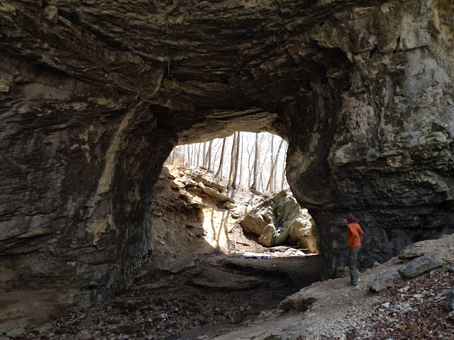
From near where the orange jacket girl was standing:

Back towards the stairs:

RE: the arch I didn't realize I ran over:
These pictures don't give a true sense of the scale.
From bottom of stairs
From near where the orange jacket girl was standing:
Back towards the stairs:
Mar 30, 2015 4:17 PM
#
A batch of photos have now been uploaded to OCIN's Facebook page. We'll get them up on Photobucket, so that folks who aren't on Facebook can enjoy them, as well. More to come. . .
Big thanks to everyone who came out and raced. We'd be really happy to hear any feedback you have on the courses, both positive and negative. Criticism that comes with constructive ideas on how a given element of the course might have been better will help us learn and improve. I know some folks are hesitant to voice public criticism, for fear of seeming too negative or being accused of "sour grapes." Feel free to send me an e-mail, instead, with your thoughts on the Long or Middle courses: flyingsquirreladventures@gmail.com
Thanks again.
Mar 30, 2015 4:37 PM
#
We were fortunate enough to get a room in the lodge but rooms were limited so I know not everyone got to experience the convenience of staying there. But for us anyway, the logistics could not have been any better. Buffet dinners Fri. & Sat. night, breakfast, bus service to within 100 m of the start--it was perfect.
The orienteering side of it was great too and I especially liked the little bit of ice that poured into my cup when I got a drink at each waterstop---OCIN thinks of everything!!!
The orienteering side of it was great too and I especially liked the little bit of ice that poured into my cup when I got a drink at each waterstop---OCIN thinks of everything!!!
Mar 30, 2015 4:54 PM
#
Stephanie--
I thought the middle and long courses were very good--great use of the terrain and met the expectations of the two respective disciplines.
This isn't a criticism, per se, but more of a wish... I was hoping for more exposure to the the funky rock stuff on both courses. I guess you guys did use a lot of it, but I was hoping for more. Sort of like dessert, maybe. Also, on both courses, that came at the end. Logical, but if there would have been some way to mix it up a bit...?
Finally, one small quibble--I think heights are important to include on control descriptions where applicable. This can affect how aggressively one can approach a leg and drives feature visualization; it would have been nice to have available.
In any case, those are hardly complaints. I thought it was a great event, as Flying Pigs are. OCIN's reliability is tremendous, and you all deserve immense credit. I can't wait until the next one!
Mar 30, 2015 6:57 PM
#
Thanks very much, j-man. I'm interested to hear what others think about more of the "funky rock stuff." I love clambering over rocks (big boulder-strewn creeks are one of my favorite things in the world). Coming from an adventure racing background, my inclination is toward a more rugged, physically demanding course. However, I was steered away from areas that were considered too rocky, too steep or too exposed for runners going at top speed, which meant leaving out some scenic and technical areas. My assumption is that adult runners, anyway, will respect the terrain and slow down where they obviously need to slow down. But I haven't had the opportunity to watch elite runners racing on very rough or difficult terrain, so I can't really speak to that with any authority. I'd like to hear from a broader range of runners about their "risk tolerance" in orienteering meets. I'd love to see some examples of a Middle course someone else might have designed in the same area.
Mar 30, 2015 6:57 PM
#
carlch - we'll pass your kind words along to the Park. I'm certain they'll appreciate it.
Mar 30, 2015 7:30 PM
#
I think there is a fine line... physicality is fine, but you don't want to go too extreme. All types (sprint through long) of orienteering are better (IMHO) the faster you can run in the terrain, on average. Extremely steep, side hills, chunky rocks, cliffs, fight, are all fine in moderation, but there is a risk of overdoing it. My rule of thumb is to minimize the amount of time that a world elite competitor (not a middle of the pack USA runner necessarily) would have to walk.
Mar 30, 2015 10:01 PM
#
I thought the Long was exactly what the doctor ordered, excellent options for route choices on just about every leg, the real test coming in that last loop. The beginning of the Middle could have been a bit more technical, but I'm not sure the terrain exactly allows for that other than going more to the extreme west of the printed map, and by then the start logistics may get complicated. The length of the Middle was right on.
The Sprint, as several have pointed out, was about 30% too much of an excellently good thing, but then I shouldn't be talking. It's all too easy for the mapper to get too excited about showcasing the terrain if the mapper is also the course setter. Given the best terrain in the middle and the SW of the Sprint area, perhaps starting somewhere around CP #5 (for Blue) would have been a good answer, and would have saved some time on mapping, too. (Similarly, last year's Trials Middle, for which I am solely responsible, should have ended at Nortonville.)
The Sprint, as several have pointed out, was about 30% too much of an excellently good thing, but then I shouldn't be talking. It's all too easy for the mapper to get too excited about showcasing the terrain if the mapper is also the course setter. Given the best terrain in the middle and the SW of the Sprint area, perhaps starting somewhere around CP #5 (for Blue) would have been a good answer, and would have saved some time on mapping, too. (Similarly, last year's Trials Middle, for which I am solely responsible, should have ended at Nortonville.)
Mar 30, 2015 11:27 PM
#
With respect to the sprint... I was thinking exactly the same thing... that to trim distance, it would have been good to lop off early controls. All things equal, that is where the "fat" was on the course (IMHO.)
Mar 31, 2015 1:05 AM
#
I originally had wanted to start the sprint farther north and west, which would have shortened the advanced courses, but every place I looked at offered too good a view of controls and runners - there was just no place to do a start that didn't give later starters an advantage of seeing a lot of the action.
I actually had originally planned courses to start at the south end of the cemetery gates, but there was just no way to call people up there without later starters gaining advantage by being able to see earlier starters and controls for a substantial distance.
If the late snowstorms and campus closures (2 full weeks) hadn't delayed completion of the map and courses, perhaps I could have found another start that would work. Every place I tried either was too far from possible parking or couldn't screen views of earlier competitors.
We didn't want to bring 300 extra cars into campus and across campus roads, so that limited start or walk to start. Parking options were somewhat limited and we knew a lot of people had a risk of late flights and arrivals. The finish pretty much had to be at Outdoor Adventures.
Bottom line, I knew they were a bit long, but didn't want to sacrifice the most interesting parts of the map just to get the length down.
Mar 31, 2015 10:43 PM
#
I loved all the courses and thought they were brilliant. even if i did start to curse all of the briars!
Mar 31, 2015 11:47 PM
#
Can only express a deep appreciation to the producers of this US Champs weekend. It was an Orienteering experience of the top level. Thanks to Mike and all the volunteers for the success of this enormous undertaking.
Apr 1, 2015 2:54 AM
#
Speaking about Long and Middle only, I think this meet would be OK if it was just a regular Pig. For the Champs, I found information on the event website to be inadequate and even misleading, no real write-up from the Course Setter team about the map/terrain/forest type/courses. Example: “Thorny vegetation including greenbriar and multiflora rose is not common here, but does exist in a few places”. Really?
Long Map was cut on the route of leg 9-10 on Red course. Event controller would easily spot it. The kind of questions that the course setter is asking here make me think Did she have a chance to ask them to the course adviser?
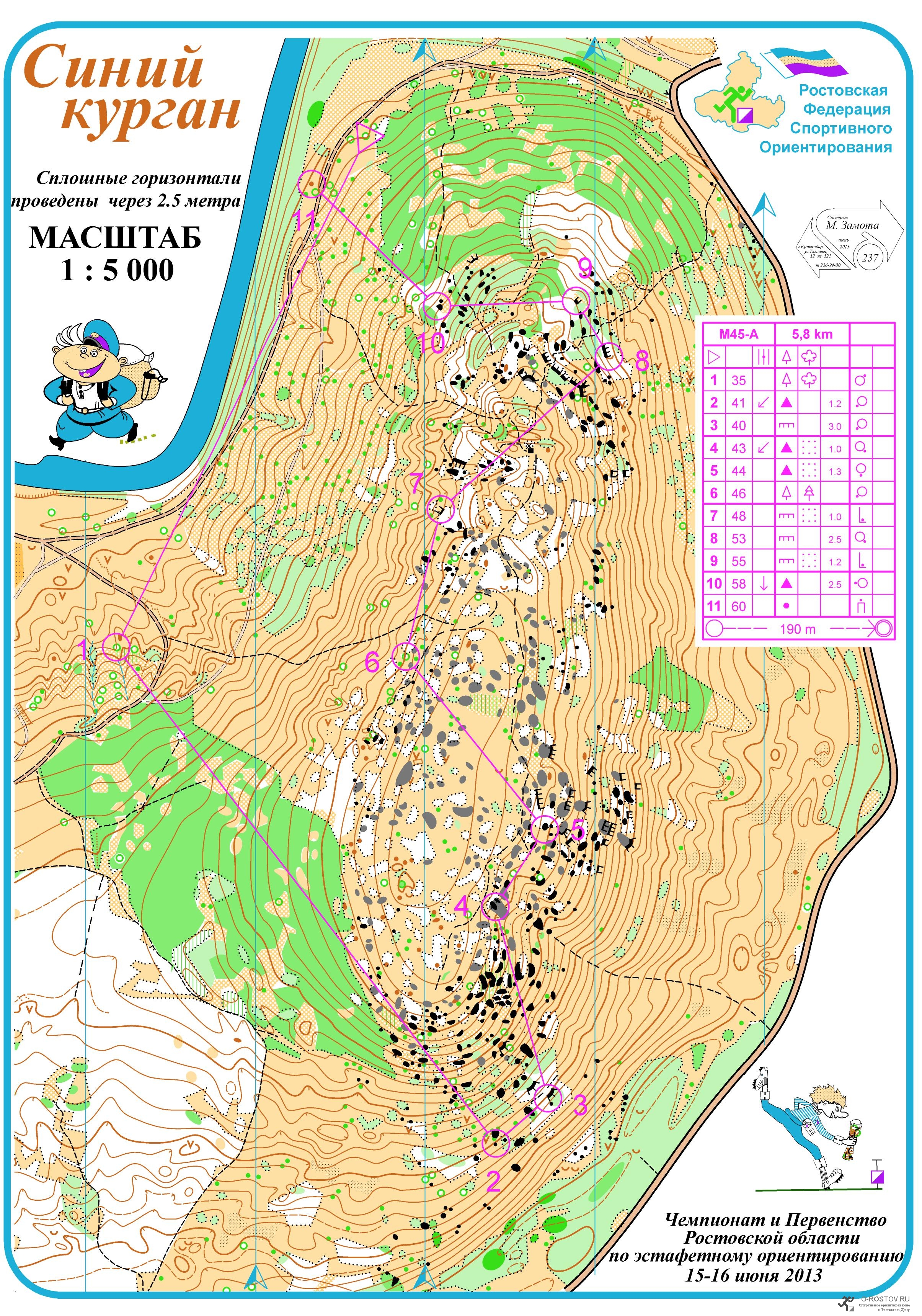
I liked the last maybe 1/3 part of the courses, both days, this type of terrain with cliffs and complex relief with rocky formations could be used way more than it actually was. It can be mapped in a larger scale, like 1:5,000. This is also good for safety. Here is an example:
http://o-rostov.ru/uploads/posts/2013-06/137192280...
I thought higher fees of the Champs would give clubs resources to approach the event seriously, but no it appears the money go to satisfy the bureaucracy’s growing appetites, and I hear again about overworked/abused volunteers.
Example: The website says (as of today): Registration is at the Lodge. I drove there on Sat morning, found a sign inside saying “Registration at Campground Shelter”. Found no such thing on the map, drove thru the park to what looked like Campground, found no signs, approached several people with the question: “Where is Shelter here?” Driving around, eventually I spotted a table with what looked like envelopes/packages, but there was no sign. I approached a man, sitting in the car nearby: “Do you know where registration is?” He answered “Here”. I asked “But where is the f.. shelter?” He responded “Oh, it’s too cold in there”. He gave me my package. I spent extra 30 minutes on the search, got to the start line 5 min. before my time.
Long Map was cut on the route of leg 9-10 on Red course. Event controller would easily spot it. The kind of questions that the course setter is asking here make me think Did she have a chance to ask them to the course adviser?
I liked the last maybe 1/3 part of the courses, both days, this type of terrain with cliffs and complex relief with rocky formations could be used way more than it actually was. It can be mapped in a larger scale, like 1:5,000. This is also good for safety. Here is an example:
http://o-rostov.ru/uploads/posts/2013-06/137192280...
I thought higher fees of the Champs would give clubs resources to approach the event seriously, but no it appears the money go to satisfy the bureaucracy’s growing appetites, and I hear again about overworked/abused volunteers.
Example: The website says (as of today): Registration is at the Lodge. I drove there on Sat morning, found a sign inside saying “Registration at Campground Shelter”. Found no such thing on the map, drove thru the park to what looked like Campground, found no signs, approached several people with the question: “Where is Shelter here?” Driving around, eventually I spotted a table with what looked like envelopes/packages, but there was no sign. I approached a man, sitting in the car nearby: “Do you know where registration is?” He answered “Here”. I asked “But where is the f.. shelter?” He responded “Oh, it’s too cold in there”. He gave me my package. I spent extra 30 minutes on the search, got to the start line 5 min. before my time.
Apr 1, 2015 3:34 AM
#
Yurets, sorry that you had so much trouble finding registration. The decision was made last minute to move registration from the lodge to the campground, in order to be more conveniently located to arriving competitors. Following the large orange and white "orienteering" signs led directly to the campground entrance, where another 2 foot (.6 meter) square sign said "registration" and pointed directly at the registrar's car, while an adjacent equally sized sign said "parking" and pointed straight ahead. You were not the only one confused - our apologies for that - but the signage couldn't have been a whole lot clearer.
Apr 1, 2015 4:14 AM
#
It's too bad he eventually found registration. Otherwise, he would have only complained about one thing.
Apr 1, 2015 5:39 AM
#
bee:
Overall, I thought the courses, map and event organization were all one could ask for. Many thanks to all those who worked so hard on those cold days to bring it off without a hitch (at least, none that I noticed ;-)
Flying south to enjoy a little warm spring weather and then finding ourselves in a deep freeze was a rather ironic experience, however.
Flying south to enjoy a little warm spring weather and then finding ourselves in a deep freeze was a rather ironic experience, however.
Apr 1, 2015 11:24 AM
#
If you have your SPORTident and are cutting it close, why do you need the (...) registration?
Apr 1, 2015 12:26 PM
#
bats would have found the registration location using ecolocation...
Apr 1, 2015 1:27 PM
#
On the length of the Sprint courses, I thoroughly enjoyed Green M, and wouldn't wish for it to be any shorter. Maybe this will start a trend towards longer Sprint type courses. We can only hope ...
Apr 1, 2015 2:27 PM
#
Sorry to go off topic: Gary, a "sprint" should be just that - short. I see no reason that we can't have longer urban events, maybe a middle distance style campus event. But, if you're going to bill a race as a sprint, please make it one. The physiological difference between 13 minutes and 19 minutes is significant.
Back on topic: I really enjoyed the course setting of the sprint, though there were a few routes that I took twice. That would have been an easy way to shorten it. As has been said, the sprint was too long. I understand the constraints imposed, but for a US Champs, we should strive to respect the guidelines. That said, this was a really fun "sprint", lots of interesting twists!
One thing that bugged me - the control descriptions seemed to be printed in a much larger font size than is usual. I haven't looked up the specs to see what's acceptable, but for the sprint, with 24 controls I had no chance of fitting the descriptions in my holder. I would have really liked to have had it in a smaller font.
As I think others have said, I found the class structure to be overly confusing. Either numbers or letters would probably simplify it. I'm not the only person who ended up with the wrong map or descriptions because of the wacky class labels.
Regarding course layout and map printing, it was nice that the course setters often cut the lines, but it would have been a lot nicer if the purple had been digitally overprinted, rather than knocking out everything below it. I had problems because of this in both the sprint and the long. I think Purple Pen will automatically overprint the purple now, if you use that.
Thank you to all who made this meet possible. It was a very fine three days of orienteering, in a part of the country I had never had a chance to visit before. Totally worth the visit!
Apr 1, 2015 2:42 PM
#
I haven't looked up the specs to see what's acceptable
Per an IOF spec I found, the squares need to be between 5mm and 7mm square.
I think Purple Pen will automatically overprint the purple now, if you use that.
Correct. This feature was added sometime in 2014.
Per an IOF spec I found, the squares need to be between 5mm and 7mm square.
I think Purple Pen will automatically overprint the purple now, if you use that.
Correct. This feature was added sometime in 2014.
Apr 1, 2015 4:11 PM
#
You can always run up to get a longer course (provided that isn't your class already). Of course then sometimes there's a tradeoff between being competitive and seeing more of the cool sprint terrain
Apr 1, 2015 6:13 PM
#
Thanks acjospe. We tried to make the course class structure names as clear as we could, given the constraints imposed on us by the WOC and JWOC selection races. The JWOC selection committee wanted the JWOC candidates to run the same course as the WOC candidates on the sprint and middle, so we had people who normally run green (F-20) on the same course as F-21+ (red) and people who normally run red (M-20) on the same course as M-21+ (blue). We knew this would be potentially confusing so we tried to use both letters and numbers to clarify. And having to accommodate the AFJROTC classes for their national championship added yet another layer of complexity. We considered several naming and numbering schemes to try to make things as clear as possible.
Another possible solution would have been to just have separate map boxes for each class, but with more boxes and different maps comes an increased risk of mistakes from the organizing and printing end. We're certainly open to suggestions for improvement when these complex situations arise again.
Another possible solution would have been to just have separate map boxes for each class, but with more boxes and different maps comes an increased risk of mistakes from the organizing and printing end. We're certainly open to suggestions for improvement when these complex situations arise again.
Apr 1, 2015 6:40 PM
#
My biggest complaint with this event is that the map bags were sealed too tightly. I had a devil of a time ripping the bags open and ended up crinkling my map. I don't know what the IOF rules are on this but I prefer to have about 1cm left unsealed in one of the corners. Also, only about 2N of force should be applied for about 2 sec. That way the seal is reasonably robust but when I stick an pen in the corner and pull it easily breaks the seal apart. Don't even bother suggesting scissors because I can't take those on an airplane when flying to A/National/Flying Meets/Events/Regattas/Pigs.
I've got more complaints too. Go ahead and ask me. I dare you.
I've got more complaints too. Go ahead and ask me. I dare you.
Apr 1, 2015 6:41 PM
#
The solution is to not try and encode class information into the course names, and just have numbered courses. Everyone knows what class they are competing in, but not what course. They just know that they are on a course that meets the requirements for winning time for their class. You still have to publish a table before hand of course stats for each class, but knowing at the time you race what other classes are on your course shouldn't matter.
The color names are really for non age class events where you need to be able to choose what course to run based on the course name, and the color tells you about difficulty and length. At an age class event, you don't get a course choice, so the colors don't add any useful information.
The color names are really for non age class events where you need to be able to choose what course to run based on the course name, and the color tells you about difficulty and length. At an age class event, you don't get a course choice, so the colors don't add any useful information.
Apr 1, 2015 6:53 PM
#
The classes and course #s were listed on each bin of maps and on my bib. Because there were sometimes two bins of red maps, I made sure to check my class. That was burdensome.
Also, the results TVs went down for a while and I had to look at a piece of paper. Boy-oh-boy, you sure didn't want to talk to me then. I was particularly put out by the whole epunch set up because on Sat the epunch staff would not accept cookie bribes.
Also, the results TVs went down for a while and I had to look at a piece of paper. Boy-oh-boy, you sure didn't want to talk to me then. I was particularly put out by the whole epunch set up because on Sat the epunch staff would not accept cookie bribes.
Apr 1, 2015 7:26 PM
#
I thought the event was well done and a fantastic experience. The terrains in all three races were interesting and varied, and the organization was in general very well executed.
Two suggestions:
- Like acjospe, I wasn't able to fit the control description into my large holder without folding parts of it on the middle and sprint. On the sprint, I had to cover four controls to fit it. I'd happily sacrifice some size and readability for being able to see all the descs.
- I may have overlooked this info somewhere else, but why were F21 and M21 long printed at 1:10 instead of 1:15? I strongly prefer 1:15 for elite long.
Congratulations and kudos to OCIN on another great event!
Apr 1, 2015 9:04 PM
#
just to chime in on what was just said above, i remember reading upon registering very close to deadline that M21 Saturday Long was going to be printed on 1:15 scale. Learned after the event that it was instead printed on 1:10

(click on image above to get a more readable image...)
(click on image above to get a more readable image...)
Apr 1, 2015 9:34 PM
#
Really enjoyed the entire weekend. Thought the courses were excellent. The Sprint was probably the most challenging urban sprint I've experienced in the US. The Brown was a bit too long, could have been made shorter without sacrificing quality by moving the start somewhere to the west, but Mike already explained why that wasn't a good option - 'nuff said.
Two concrete (pun intended, as you shall see) suggestions about controls on the sprint:
1. Brown #1 (control 40) was mapped as a tiny square of pavement and the control description was "paved area". In fact, what was there was a vent of some sort: four vertical walls, maybe half a meter high, 2m long, with a horizontal metal grate as a roof. Don't see how this was a paved area. Black X would have been a better map symbol, with a corresponding control description. No one else I spoke with was thrown off by this (they just ran to the center of the circle), but I stood there for several seconds puzzled because I didn't see any pavement.
2. Brown #6 (control 72): This was described as "building, wall, inside the N corner." First, seems like a "junction" symbol should have been included on that line; second, "S side" (of the junction) would have been a less ambiguous description. (Had there been no building but rather an extension of the wall where the building was, then "inside the N corner" would have been appropriate.)
Thanks again to Mike and all the organizers for a great weekend of orienteering!
Apr 1, 2015 9:57 PM
#
walk:
Another fine Pig. Thanks to Mike and all that those made it happen. Really enjoyed it all. The following is meant as feedback and not as criticism or complaints as I did have fun and found the courses a challenge.
First, the split of the Brown course was unusual being based on age versus the normal gender split, and perhaps unnecessary with the numbers involved. I would much prefer to run with combined 65, 70, etc.
Course length of the Sprints have been mentioned and discussed. I note that the Brown Long was on the short side with times in the low 40 minutes and below. Also the 70+ course was mostly a trail run with pop into the control and back out - Yellow?
On the Sprint I had the same difficulty as Dennis with number 1 and tried to describe as he did to others that had no problem. Either use a square wall on the map or the black X.
For the Long, control number 7 located on the east side of the stream but the control circle was centered on the west side. I stood pondering for a bit till I almost gave up and crossed the stream to continue on and saw it.
9. I could make no sense of the exit from 8. Both the map and the terrain looked like a big impassable cliff. No indication on the map of a tunnel or cave. Use of the caves was novel but not for a National Champs, please.
On the Middle, Control 10 (#53) clue was a dot knoll but the map showed only two black dots in the circle and in fact the control was stuck in a small niche of a boulder.
Thanks again for a great weekend in Kentucky and please pass along many thanks to the State folks for the great venue and help.
Apr 1, 2015 10:31 PM
#
1. Very good quality maps including really white and non-glossy paper.
2.. All controls on all courses are in place (I am too tired from misplaced or even missing controls during USA Championships).
3. Interesting and challenging courses with variety of choices and types of techniques needed.
4. Nice social program
= excellent meet.
There were some glitches as above mentioned but they didn't spoil the moment.. I could add that controls in pits may be placed higher above the ground to avoid some bingo factors.
I am always looking forward competing at Flying Pig events as OCIN under Mike's guidance knows what to do and have system in place for high quality meets!
Thank you very much!
Apr 2, 2015 12:41 AM
#
Iamstillhungry, you must have a food focus (understandably) - reliable sources have reported you would have gotten further with a Diet Coke bribe with at least half the epunch team!
Great weekend - we very much enjoyed the freedom to stay an extra day and enjoy the park while not on the clock. Great venue, hope to run there again.
Anna loved the white course that brought her through the arch, it was the highlight of her weekend.
I join the group of confused red/green/whatever in having picked up the wrong control sheet for the sprint. With the start stations occurring on a timer when we're all trying to focus, perhaps a reminder sign before the call-up line would reinforce the departure from usual procedure and the need to focus on course number rather than color?
Apr 2, 2015 3:38 AM
#
2 Newtons for 2 seconds? That's crazy talk. OCIN would never be that reckless.
Apr 3, 2015 4:23 AM
#
BTW, great touch having the detailed labels on the back of the medals, including the medal-winner's name. Well done!
Apr 4, 2015 3:02 PM
#
I also very much enjoyed all the courses.
I didn't see the following explicitly discussed, but I can guess why the medal-returner crossed an uncrossable wall and traversed an olive area. On the Green M sprint course, the line from 10 to 11 mostly obscured an uncrossable wall. Unfortunately that gave the appearance of an optimal route that didn't exist. In discussion with the other competitors, many got caught up by this.
For course setters, this serves as a reminder that they should make sure that significant features aren't overprinted by the control circles and connecting lines.
Apr 7, 2015 2:46 PM
#
Yurets - I was the course setter for the Middle courses, but not the Long. To address your speculation as to whether I had access to a course consultant, please know both the Middle and Long courses were thoroughly reviewed by two course consultants. My Middle courses went through approximately 8 iterations before they were declared final. So, it wasn't a lack of access to quality, engaged course consultants that gave rise to the questions I posed. It was a lack of complete agreement between all of us regarding portions of one or more courses that gave rise to the questions I posed to this wider audience. As I alluded to in my earlier post, there were some areas I would have liked to have taken runners that I did not due to concerns by the course consultants that were not shared by me. I wanted to give folks an opportunity to weigh in on the issue so their preferences might be taken into consideration in future events. In the two times I've designed courses for an A-meet, I would certainly describe the final product as a "design by committee." I'm optimistic that a better understanding of expectations will give me a greater measure of independence and confidence in designing courses.
Apr 7, 2015 3:35 PM
#
If A-meet course design feels like "design by committee", imagine how much that's the case for WOC courses. More committee members, all with agendas and strong opinions.
Apr 7, 2015 4:07 PM
#
I feel like good course setters are artists in the mold of a Martin Demaine. Incorporating apprehension of technical underpinnings and rules with expression and verve. The rules of art (adherence or not to the chromatic scale, color juxtapositions, brush strokes, proportions, etc.) can be assessed by the experts, but the course is best understood as an emotional/physical experience by the runner.
Art collapses under the strictures of a committee. Legislation, on the other hand...
Art collapses under the strictures of a committee. Legislation, on the other hand...
Apr 7, 2015 5:21 PM
#
I had no issues with the middle, except the first 2/3 of the course could have been, and i feel, should have been, made more technical. On this kind of terrain ("standard Pig-type") this could be achieved by increasing the length of a leg somewhat. And the last part of the course was both tough and enjoyable, imo.
As to the Long: as I mentioned already, cutting map just on the trail (9-10 Red) prevents runners from seeing the situation on the right side important for making the decision when to leave the trail. Other than that, it is a matter of taste. I would avoid, for the trial event at least, parts of the map heavily overgrown with thorny vegetation (3-4-5-6 on Red). Nevertheless, overall, the course was a good one.
As to the Long: as I mentioned already, cutting map just on the trail (9-10 Red) prevents runners from seeing the situation on the right side important for making the decision when to leave the trail. Other than that, it is a matter of taste. I would avoid, for the trial event at least, parts of the map heavily overgrown with thorny vegetation (3-4-5-6 on Red). Nevertheless, overall, the course was a good one.
Apr 7, 2015 5:29 PM
#
Can anyone comment on why the M21/F21 long scale was changed to 1:10000 instead of 1:15000 as initially advertised? Thanks.
Apr 7, 2015 5:31 PM
#
Because they wanted to give you a better advantage at the Billygoat, Mr. Classic Orienteer.
Apr 7, 2015 8:28 PM
#
Ian, the M and F 21 courses ended in a section with very dense rock features. Test prints done months ago were readable at 1:15,000, but hadn't planned for the courses going into this intricate area.
When we looked at the final courses and the route choices which potentially involved finding narrow passages between cliffs, the setters and vetters (all of us admittedly with older eyes) agreed that printing at 1:10,000 would be more readable and more fair. It was a tough call to agree to - I know purists prefer 1:15, and for team trials, we really wanted to duplicate WOC conditions. But I also felt that if we went with 1:15, we'd get whining that the gaps were too hard to read at competition speed. We even tried widening the key gaps just a little and doing a few more prints, but in the end we felt 1:10 would give everyone a much better experience. Rightly or wrongly, that's where it ended up.
I'm sure many, if not most, people would have been perfectly happy with the 1:15 prints. But if we'd had a rainy day with wet map bags further blurring the view of the map, I can imagine many complaints and "I never saw those darn gaps until after the race".
Apr 7, 2015 8:34 PM
#
Thanks for the info, Mike. It's quite understandable - modern mapping standards seem to be increasing in density so much that 1:15 often isn't readable under race conditions. I was a little surprised when I was handed the long map to realize it was at 1:10, but it didn't have much of an impact on my racing. It would have been nice to know in advance that the scale was going to be 1:10.
Apr 7, 2015 8:54 PM
#
Mike, I think that there is no problem with using 1:10000 for the M/F21 classes for the long distance.
However, OCIN needed to ask sanctioning for an exemption from the rules in order to do that, and, perhaps more importantly, information on OCIN's website (http://www.ocin.org/flying_pig/pigXIX/csn_2015.htm...) should have been clearer: in one place it mentions 1:10 for all classes, in another 1:15 for M/F21.
However, OCIN needed to ask sanctioning for an exemption from the rules in order to do that, and, perhaps more importantly, information on OCIN's website (http://www.ocin.org/flying_pig/pigXIX/csn_2015.htm...) should have been clearer: in one place it mentions 1:10 for all classes, in another 1:15 for M/F21.
Apr 7, 2015 9:25 PM
#
So maybe skip the exorbitant permitting fees in HVO-land and ask forgiveness if they see you there on event day?
Apr 8, 2015 2:47 AM
#
The final decision wasn't made until the Monday evening before the event, when the final test / review maps were printed. Up until that point, we had been looking at 15,000 prints and assuming that was what we would use. Competition maps were then printed on Tuesday.
The change didn't get uploaded to the website, but the correct scale information was updated for the information packet that everybody received when they checked in. Not that anybody bothers to actually read the packet. :-)
Yes we should have then called sanctioning committee. But we were not even considering 10,000 until Monday night, so at that point it was kind of late to do much other than run with it. Yes we probably should have discussed it more and sooner. I think we all were having the same doubts about 15, but all saying - the elites have young eyes and 15,000 is what they want.
Apr 8, 2015 2:53 AM
#
I'll add that literally the first thing I did when we received the map file from the mapper was print it at 1:15000. I was really excited because the map looked pretty solid at 1:15000. It was made to be printed at 1:15000. It's just that certain parts of the Carter Caves terrain don't shoehorn well into that scale.
Apr 8, 2015 3:01 AM
#
GuyO:
Thanks for the clarification, J-J!
@Pink: What exorbitant permitting fees...?
:-D
@Pink: What exorbitant permitting fees...?
:-D
Apr 8, 2015 3:36 PM
#
Bman and I had a great time. Thanks to all who made it happen. I had no problems with the firm seals on the map bags. First rate!
A question (not a complaint) on the middle course, was there tape from the go control to the finish?
With my own A-meet course setting experience, I received a lot of information and guidance about what the course should and shouldn't be, especially from the course consultant. But I don't remember any formal process for inspecting the final maps (the course overlays, especially cuts). My courses were not finalized until the week of the event. A common occurrence? And by that point, I was really tired of looking at the maps (I suspect the course consultant was too). Therefore, missing a crucial cut would be fairly easy on a highly detailed map.
Purple pen might be a solution.
How do other clubs handle this?
Apr 8, 2015 5:31 PM
#
The middle course had pin flags from the GO control to the end of the tapes. Due to crossing the parking lot, we used the pin flags instead of tapes until past the parking lot.
Apr 8, 2015 7:14 PM
#
One thing (not necessarily a problem at the Pig) is the finish chute on Sprint -- I think it should be more prominent than for Middle and Long.
Or maybe I am mistaken and we are supposed to navigate to the finish circle, but frankly my brain stops working just before I punch the go control, and it would be great to have a large banner saying "FINISH" and have the finish punches right under that.
Or maybe I am mistaken and we are supposed to navigate to the finish circle, but frankly my brain stops working just before I punch the go control, and it would be great to have a large banner saying "FINISH" and have the finish punches right under that.
Apr 8, 2015 8:57 PM
#
You just need to pretend that there's one more circle so that your brain stops working just before the finish punch.
Apr 9, 2015 5:44 PM
#
Surely you have looked at the finish symbol many times, JJ. There are already two circles after the go control! But it seems that ideally the brain would turn off just after the finish punch, rather than just before.
Apr 9, 2015 6:11 PM
#
My understanding is: if it's a solid line connecting the GO control and finish circle, then you're supposed to navigate. If it's a dashed line, there's flagging or a marked route.
Apr 9, 2015 7:16 PM
#
Guskov, normally the finish is in the arena which you are allowed to visit (which it is standard to visit?) Before your race. Take a few minutes before starting to specific look for where the finish is and what the finish chute looks like. (What direction does it come in from, how is it flagged, does it connect right to the go control, etc.) If you look at this stuff in advance it won't catch you off guard in the race.
If you're really keen you can try and see which direction athletes are approaching the go control from to get even more of a boost.
If you're really keen you can try and see which direction athletes are approaching the go control from to get even more of a boost.
Apr 9, 2015 7:34 PM
#
@Canadian:
Thank you for the tip. How is it that I never thought of doing it?
Maybe because the locator map
http://www.ocin.org/flying_pig/pigXIX/pigXIX_locat...
sort-of implied the warm-up area did not include the finish.
To the point, I vaguely recall, at the last control, I had some doubt where to go (the marking-flagging was not very clear), had to read the map to decide how to get to the finish line-- once I got to the parking lot--finish was visible ahead.
Apr 9, 2015 9:15 PM
#
Yeah, still a large banner always helps. But checking out the finish area before starting is a good advice. You will not see the runners though if you are the first to start. And then making it more obvious also makes it more fair. I mean the actual finish location. Alternatively make the chute converge to that point on both sides.
It was all embargoed and fair at the Pig though, wonderful Sprint map and courses as well and awesome live results. :)
It was all embargoed and fair at the Pig though, wonderful Sprint map and courses as well and awesome live results. :)
Apr 9, 2015 10:20 PM
#
walk:
All finishes were in embargoed areas. You could see the long finish from the Visitor Center, but the map indicates that going to it was out of bounds.
Apr 9, 2015 11:11 PM
#
A finish banner is nice, but having been in charge of the finish/results many times, I can report that you can park a van in the middle of a prairie, put a big banner reading "FINISH" right next to it, and run strings of pennants toward the last control, but you'll still get people either running around the end of the string of pennants or crossing them as they head off toward some mysterious location. And you can set up the same van and banner and pennants on the next day's map, and they'll do it again, all week long.
Apr 10, 2015 1:24 AM
#
The middle and sprint finishes were well inside embargoed areas and could not be visited. The long finish was on the edge and could clearly be seen and scouted from the road.
Routes from the last control were fully marked on all days.
Both the map (solid line versus dashed line) and the control description sheet tell you whether you need to navigate or have a marked route.
I'd add that I too like to scout finishes when possible and my general preference is to have the finish visible and near parking. However, parking options for 400 people are pretty limited at Carter Caves and at Morehead. Also, having the finishes inside embargoed areas eliminated a need to quarantine elite / team trials runners before their starts, which is a hassle and extra staff-power for organizers, and an annoyance for runners if you have to be in quarantine for a long period before your start.
Apr 14, 2015 2:59 AM
#
Wasn't the finish banner hanging at the Sprint, with the finish controls directly under it, and pennants on both sides? Maybe I'm misremembering, but I thought that was the case.
Apr 14, 2015 2:58 PM
#
At the sprint, the finish banner was directly behind the finish punches on 1 meter posts. It is better to have it directly above the finish, but we were not permitted to put up poles tall enough to suspend the banner high enough above the controls for runners to pass underneath. So the banner was placed less than 2 meters behind the controls. From the last control to the finish, There was a building on one side of the chute and parking lot on the other. There was a solid line of streamers along the parking lot side, and a line coming out from the building on the other. I don't think the comment about finish chute streamers was specifically related to the sprint at Morehead - the chute was pretty well marked.
Apr 14, 2015 4:21 PM
#
If the finish area is accessible, I always check it out.
My question was specific to the Middle course on Sunday. I got to the go control and didn't know where to go. Didn't see any tape (clue sheet said tape to finish). No recollection of pin flags, I was thinking too literally and looking for tape.
The Sprint and the Long finishes were both visible from the go and well marked.
This discussion thread is closed.