Discussion: Better Bluetooth GPS for windows tablet
in: Orienteering; General
Feb 18, 2015 4:32 PM
#
Hi,
I have been using OCAD 11 on a Dell Venue 8 Pro 64 GB Tablet (Windows 8.1) for field checking and map development. I also bought Bobj Rugged Case for Dell Venue 8 PRO Windows 8 Tablet and Original Dell Active Stylus Version REV A02 With Battery for Venue 8 11 Pro Windows Tablet. The tablet, stylus and cover are al working great. However, I bought the GlobalSat BT-368i Bluetooth GPS Receiver and that is not working out so great. It works well when it works but it keeps shutting off and then I have to mess with turning it back on, disconnecting and reconnecting it and AAARGGGH. So I need a better bluetooth GPS. Anyone have any good experiences with Bluetooth GPS? I am looking at the Dual XGPS150A. Anyone use this.
Also, the bluetooth mouse sounds like a great idea. Any suggested models that work better then others?
Mike the little map maker
Feb 18, 2015 7:47 PM
#
I have a GNS 2000 which works great with my Android smartphone. < $100 at Amazon. It has a up-to-snuff MT-3333 GNSS chip; so GPS+GLONASS (some 40% better than a single) if you live in American longitudes. Does have stand-alone logging also. It is intended for private aviation use and acquires at 5 sec intervals - which is slow. I need to take it easy around sharp turns and I wear it in a cap. It’s way better than my old QStarz logger.
Feb 18, 2015 11:09 PM
#
I have a garmin Glo that has the Glonass also. I connect to Samsung tablet, windows 8.x and Ocad11. The Glo works well generally but I also have periods where the tablet and GPS lose connectivity. Over a 4 hour mapping period I will lose the connection ~6 times. Most time I just need to reconnect. Some of the times I have to actually power cycle the GPS to make it reconnect.
Other than the reconnects, it works for me. There are a few areas in steep valleys that no GPS works well but that isn't limited to just one GPS. the only nuisance I have with the GPS is that charges only via a mini USB port so I have to connect it to a computer to recharge (as opposed to a normal electrical plug).
I also wear the GPS on a ball cap when it warm out or on the collar when it cold.
Feb 19, 2015 12:53 AM
#
A GNSS device works way better in the hollows - with at least twice the number of satellites. A directional antenna keep the sidehills reflections lower. The credit card sized GNS2000 is flat and in a cap it points fairly well upwards. Which orientation is optimum for the Glo? It has a odd shape.
Feb 20, 2015 3:15 PM
#
I am leaning to the GNS 2000. But I need to figure out a better method then under the hat. We have a lot of thick underbrush, Bush Honeysuckle, and it keeps pulling my hat off. The good news is that you know the location of the device since OCAD holds the last position when it lost contact. :-) Also I am going to load GPS Gate client software http://gpsgate.com/products/gpsgate_client some of the comments I have seen and the website indicates that it "Stabilize the GPS connection" . That may help with the Garmin Glo, Tdgood!
Feb 21, 2015 4:39 AM
#
the only nuisance I have with the GPS is that charges only via a mini USB port so I have to connect it to a computer to recharge
http://www.jaycar.com.au/productView.asp?ID=MP3455 (or the US equivalent) and http://www.jaycar.com.au/productView.asp?ID=MP3664 for your car. Most useful things to have these days - especially when you're just about to leave for orienteering and realise your GPS/phone/tablet is flat.
Feb 22, 2015 1:42 AM
#
I have used an iBlue 747 Pro Data Logger worn in my hat while using a Motion tablet and OCAD 10. The 747 has never given me a problem. It will last through a 24 hour rogaine too. I use it to record runs. When the satellites are favorable, it is good under forest canopy. When I run on a track and change lanes on each lap, it will usually show that when I check the track on a georeferenced photo. About $70 on Amazon. http://www.amazon.com/747proS-Recorder-channels-wa...
Feb 23, 2015 3:34 PM
#
Mike,wear your receiver away from body shadows to get best positions. The strengths of the signals are very low and at 1.2-1.6 GHz body parts attenuate quite a bit. How about mounting it in i bike helmet or in the top pocket of a somewhat filled backpack.
If you are concerned about running out of power in the tablet, there are slick Portable Charger Power Packs (USB but also multi-voltages). I have an Anker Astro 20Ah(!) – for something entirely different.
If you are concerned about running out of power in the tablet, there are slick Portable Charger Power Packs (USB but also multi-voltages). I have an Anker Astro 20Ah(!) – for something entirely different.
Feb 24, 2015 1:27 AM
#
For the Garmin Glo "Which orientation is optimum for the Glo? It has a odd shape".
I have not found there to be any better or worse orientation. It comes with a clip the limits how to hook it on. It lays flat on the hat brim.
When I hook it to my baseball cap brim, I also hook it to a string on the hat so it doesn't fall off the brim and I don't realize it. (i.e I the string keeps it attached to the hat).
When I wear it on my collar in cold weather (because I am not wearing a ball cap) , I haven't noticed any problems with the reception or shadow reflections.
Feb 27, 2015 7:58 PM
#
So I think I have settled on the gns2000. The reason I eliminated the Garmin Glo is that it has a power off if it losses Bluetooth connection and the experiences that Tdgood described are identical to the issues that caused my search for a replacement. The GNS2000 states that it to has the power saving feature. But since the GNS2000 has data storage, I hope that it will stay on if you are saving data. Plus being able to download the track is nice.
The comment about a .2 hertz update rate (once every 5 secs) is a minor concern. I could not find anywhere in the product literature what the update rate is. But since it is to be used for field checking, I will not be running and when I need it accurate I will be stopped.
Thanks for the comment about mounting it away from your body. I will cone up with a e/eternal hat mount with tether and a backpack mount
I will provide my findings in a few weeks after I have used it a couple of times.
Mar 11, 2015 12:15 AM
#
Well, that is interesting. I got the GNS2000. It pairs nicely, it connects to OCAD nicely, it is very accurate, it does not need much of the sky to get a bunch of satellites, it will not update unless I move 15 meters! WTF!!!
I have no idea what the update rate is since it will not update unless I move more then 15 meters from my last position. I guess this is not an issue if you are in a jet going 500 MPH but when you are walking and would like to define the curve in a trail every 15 meters does not cut the mustard.
This is going back in the box and back to Amazon.
Garmin Glo is up next.
Stay tuned!
Mar 11, 2015 1:42 AM
#
Hmm, I have not seen that. I have done a lot of ski trails with fairly tight turns. But not close-by discete points. And have always imported GPX files into OCAD11 either from the GNS2000 itself or from a Smartphone. And I assume that you have considered the .2 Hz acquisition rate.
Notify the manufacturer, please.
Notify the manufacturer, please.
Mar 11, 2015 3:53 PM
#
So here is the bottom line on the GNS2000
"thank you for your enquiry and information. The GNS 2000 transmits the current positons every second when the minimum speed does not drop below 3.5 km / h.
The GNS 2000 holds a calulated position for around 20-30 m when the speed is lower than 3,5 km/h (static navigation)."
So if you are a skier blazing down slopes, you are fine and you should get an update every sec. But if you a a bumbling orienteerer trying to get an good position on a feature..... No go. Unless you run around it. I guess you can walk fast
Great device.....except for the static mode issue.
Garmin Glo will be here tomorrow. I will take it to the woods on Friday.
Stay tuned!
Mar 12, 2015 9:38 PM
#
So the Garmin Glo showed up. Plugged it in, powered it up, took a while to get signal, in the mean time the blue tooth hooked up strange. Showed up as a headphone. It then paired nicely I then went to OCAD. I go to real time GPS and it shows 5 com ports. Well I know that the Garmin for some reason is using 5 and 6 but have no idea want is using 3&4. I test com 5, the device shows it is connected, it shows it has a GPS lock and I get nothing in OCAD. Try com 6. Same story. Try com 3&4, and the device does not show it is connected. So the dell thinks it is a headphone, for some reason it grabs 4 com ports and OCAD sees it and connects but can not get data
Aaaaaaaaarrrrggggghhhhhhhhhh!
Aaaaaaaaarrrrggggghhhhhhhhhh!
Mar 13, 2015 1:12 AM
#
Software update on Dell, couple of quick checks and..... I have data in OCAD!
I will try and get out to the field in the next few days and give an update. Did fine walking around the outside of the house
Go GLO!
I will try and get out to the field in the next few days and give an update. Did fine walking around the outside of the house
Go GLO!
Mar 13, 2015 11:20 PM
#
Now I feel like I got lucky when I bought the GLO. I don't know the update rate but it fairly frequent since I am often standing in woods (mapping) for extended periods and then walk just a few meters and ocad shows my position moving.
Mar 15, 2015 3:42 AM
#
And I'm happy that I got a GNS2000 before they "updated" their firmware even if the acquisition rate is slow.
Mar 17, 2015 12:41 AM
#
The Garmin Glo worked flawlessly! Stayed connected all day, position was great, no hiccups, surprises nothing. I Velcro d it to my hat with a dental floss backup. I was in some deep withdrawls with tree cover and no issues. We will have to see how it does once we get leaf cover but right now I am thrilled.
Neoc#1, so if you move 6 feet and stand still for 5 seconds you get an updated position?
Tdgood I should never have doubted you!
Neoc#1, so if you move 6 feet and stand still for 5 seconds you get an updated position?
Tdgood I should never have doubted you!
Mar 17, 2015 4:03 AM
#
Have you tried going over the same track several times to see how consist it is?
Mar 17, 2015 2:42 PM
#
Yes, about 1-2 meters is the worst I have seen most of the time pretty darn close. I would not use it for land survey but for trails and features it is much better than I think it is here. I had a creek that I created by using 1 meter contours from lidar. I walked the creek with high bluffs to both sides and the two tracks were very close. GPS track only varied when I had to go around tree snags.
Btw I have done terrian surveys using Trimble and other precession methods, so I understand the limits of these systems. This was pretty darn good.
I would not trust the vertical at all!
But long and lat, good enough for Orienteering mapping.
Btw I have done terrian surveys using Trimble and other precession methods, so I understand the limits of these systems. This was pretty darn good.
I would not trust the vertical at all!
But long and lat, good enough for Orienteering mapping.
Mar 18, 2015 11:40 PM
#
If you want sub-meter with out the need to post process and is small enought to fit on your belt clip. I suggest the trimble R1 GNSS receiver. You would use an app on your phone to collect the data. It would also get RTK with the GPS in the phone and the wireless data. It also collects data in a GIS format which is very helpful.
http://trl.trimble.com/docushare/dsweb/Get/Documen...
http://trl.trimble.com/docushare/dsweb/Get/Documen...
Mar 21, 2015 3:56 PM
#
contrms: Here is a test that I did last spring. The woods: Dry non-leafed trees with some conifers. I walked clockwise three loops with a cell (with GPS only; ~2008 technology) and the GNS2k, both held together at lower arm length in front of me. So there was some body shadowing. I should have had them on top of a pack. Each loop took appr. 14 minutes. The GNS2k was of course superior (2013 design).
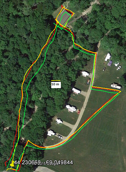
Loop: 1 - Red, 2 - Yellow, 3 - Green
It's interesting to see how good the southbound tracks are tracking. Coincident or because most satellites are to the south in front of me (I'm about halfway up to the North Pole) and are without any body attenuation? The GPS satellites reaches +- 55° and GLONASS +- 65° so the later is slightly better closer to the poles. As expected the tracking is worst in the woods - and going north. I walked about 1 m away from the roofline of the building (with metal roof) in the NW and slowed down at the corners.
The Trimble R1 looks great. How much $$$? Has anyone at China/Japan longitudes (e.g. western Australia) seen any benefits from their local BeiDou/QZSS systems?
Mar 21, 2015 4:57 PM
#
Here in Finland at 60° we see all the time GPS satellites flying somewhere between Alaska and Kamchatka. That 55° reach of GPS isn't that big issue really because we see satellites from behind the pole, only when mapping some rock hole where satellites need to be straight above. but in such steep hole there usually is good base map contours.
This is the accuracy I normally get with plain GPS:
http://attackpoint.org/sessiondata.jsp?sessionid=3...
Garmin GLO is quite popular here among mappers here and they say it is good, but I have been told it is just as good but usually not any better than those good bluetooth GPS devices they used before. But those extra satellites just may advantages when GPS geometry happens to be poor. So those are about equally when they work as they mostly do, but GLO may have bad moments less often and it's bad moments are less bad.
Mar 22, 2015 2:51 PM
#
Trimble R1, Only $2495.00. https://store.trimble.com/OA_HTML/ibeCCtpSctDspRte...
This discussion thread is closed.