Discussion: Difficulty @ Canadians
in: Orienteering; General
Jul 30, 2007 4:34 PM
#
Looks like a lot of people seemed to struggle this weekend in Saskatoon, including me!! The meet was very well organized, and everything was set-up professionally. Kudos to the organizers for being on the ball.
I felt the O was very difficult for a number of reasons. Subtle features on the map were hard to pick out and small. The windfall made it tough to get around and see in spots. The HEAT...obvious. For myself the biggest factor I think would be the windfall. I felt I spent a lot of time trying to get around the trees, and when I did get around I would be off track. I also found it very tough to attack controls and see them in spots.
Just wondering what everyone(those who struggled like me!) thought was the main reason for the high t.p.k.'s and tough O?
Jul 30, 2007 4:45 PM
#
Sounds like a very interesting event. I'd love to see the maps! Are they up someplace?
Jul 30, 2007 6:08 PM
#
Adrian Zissos is working on the routegadget (rg.orienteering.ca) as we speak but he was having some problems.
I pulled out of the long distance at the spectator control because I was totally exhausted. I'd been struggling and trying to push through my fatigue since the 4th control (maybe 2.5km in) and I blame the heat. The thick vegetation and deadfall contributed without doubt (anyone near me when I was heading to 14 has already heard my opinion of the deadfall!), but the heat made me feel awful, sapped my motivation, and was more than I could tolerate.
Navigationally, the subtle detail and poor visibility where the main challenges. This didn't bother me too much (in the long at least) as I was going pretty slow.
Jul 30, 2007 6:55 PM
#
Gouger, I think you answered your own question!!! Heat, deadfall, thick undergrowth, poor visibility, tricky terrain and heat. You named them all, what else could add to the challenge! Obviously the fact that this was a WRE and the Canadian Champs also added extra stress for some people, which can sometimes make for strange decisions. But seriously, those championships included all of the possible challenges you can meet in one event! Okay, maybe minus the poisonous snakes. If the level of orienteering doesn't improve in Canada after an event like that, I have no idea what else we can do to push and challenge our limits!!!
Jul 30, 2007 9:01 PM
#
Mark, I almost didn't continue either. i was totally frustrated, my knee hurt and I thought I was WAAAYYYYY out of it. I actually took off my compass and headband and threw my map down. Glad I slogged through in the end.
Jul 30, 2007 11:33 PM
#
I found the visibility really hard. Some depressions were completely filled with deadfall and the subtle contour features that charactersized the map were difficult to read with all the ground cover. I'm one person who loved the heat though. I also nearly quit when I was trying to cross an area that was totally impassable, just out of frustration! Glad I hung in there though. Overall, a great weekend and definitely an guarantee to have improved my technical skills.
Jul 31, 2007 7:22 AM
#
Mike Minium suggested that it was a lot like night orienteering---In some places you couldn't see far enough to know exactly where you were. I'd definitely go back (hopefully for a spring or fall event, though).
I had the most trouble figuring out which contour features were up. One of the course notes mentioned the "negative terrain" feeling you get reading the map. I found it was easy to find the bottom of everything, but not the top. I was going to ask if anyone else thought it would help to add sets of 2 opposite tag lines near each other on the ridgelines, particularly in the complicated areas. I remember spending a lot of time tracing along contour lines to find the tags.
I'm inexperienced in this kind of terrain, so I also considered that maybe it gets easier with experience. I'm not sure though. It seemed to me you had to have tags to make sense of it, and the amount of time I spent tracing the contours to find tags was almost proof the map needed more.
Jul 31, 2007 11:33 AM
#
... deadfall, thick undergrowth, poor visibility, tricky terrain ...
Just back from competing in the Fin5 west of Tampere, I was amazed by the pure physical demands of Finnish orienteering. The M65+ guys I was competing against would charge through slash, deadfall, endless marsh, dozens of 4m drainage ditches, slabs of granite covered by thick mosses, blueberry bush, etc...all at 7-8 min/km; no tentative old men in Finland!
Unfortunately my pace was about twice what it would be in the U.S. even tho I was seldom lost. For instance, I'd get up to those ditches and pause, not believing that belly-flopping into that sea of mud, and then desperately pulling myself out of the suction with the roots on the opposite shore was the only way to get across.
I returned convinced that we North American orienteers need to HTFU if we're ever going to be fully competitive on the international stage.
Jul 31, 2007 12:47 PM
#
Sid:
Being an adventure racer at my second COC's I was quite happy completing all the courses. The terrain was very challenging and the long distance was particularly tough mentally, with the most difficult terrain after the spectator control. I was particularly intrigued in the number of people that dropped out of the long distance event from heat exhaustion. From an masters adventure racing background, I have a good idea of what pace I can sustain for longer periods of time. Winning is not in the equation. By contrast, top orienteerers know what pace they have to sustain to have a chance of winning. I am realizing to be competitive in orienteering a different mind set is required.
Great job by the SOA! The terrain really expanded my experience data base, being used to eastern arboreal forests!
Great job by the SOA! The terrain really expanded my experience data base, being used to eastern arboreal forests!
Jul 31, 2007 6:36 PM
#
I tried that once.....the tree won hands down.....I guarantee that not many 65 year old Fins would of went around sat/sun in 7 min/k....especially in that heat.....almost all(few exceptions) categories had winning times in excess of 10 min/K.
Jul 31, 2007 8:42 PM
#
Depending on your definition of forest, not all of them are filled with trees... The southwestern US has plenty of cactus forest, where things are spikey but the visibility is great.
Jul 31, 2007 8:54 PM
#
"Chest high deadfall is difficult to "charge" through ? "
Unless you're the Juggernaut!!
"The southwestern US has plenty of cactus forest, where things are spikey but the visibility is great."
Yeah, beware of these forests because all the plants are out to kill you, no matter how innocent they may look...!
Unless you're the Juggernaut!!
"The southwestern US has plenty of cactus forest, where things are spikey but the visibility is great."
Yeah, beware of these forests because all the plants are out to kill you, no matter how innocent they may look...!
Jul 31, 2007 9:00 PM
#
Ratlaf, you just haven't properly calibrated your cactus espina proximity indicator radar system (CEPIRS). I didn't see a course on it at the convention, maybe next time.
Jul 31, 2007 10:32 PM
#
This was an excellent event. I was unable to stay for the long, but the middle was fun terrain, despite my problems.
My one observation about the middle mapping was that the contour features didn't seem to be quite the right shape/size in certain cases. Not such a problem if you were spot on with contact, but it made relocating a higher penalty affair. There was some concurrence with this opinion, tho I'm not sure how widespread it was. In any case, a fine event, and this shouldn't be taken as a complaint.
My one observation about the middle mapping was that the contour features didn't seem to be quite the right shape/size in certain cases. Not such a problem if you were spot on with contact, but it made relocating a higher penalty affair. There was some concurrence with this opinion, tho I'm not sure how widespread it was. In any case, a fine event, and this shouldn't be taken as a complaint.
Aug 1, 2007 2:20 PM
#
Sid:
An arobeal forest is typical in the Southern Ontario and the northern states. The term refers to tall mature forests, either deciduous or coniferous. The high treetop cover prevents much light at ground level and little vegetation. These areas are generally white on an O map. In Saskatchewan, white was a mix of smaller trees and with some ground cover and difficult to discern from hatched areas.
Aug 1, 2007 8:29 PM
#
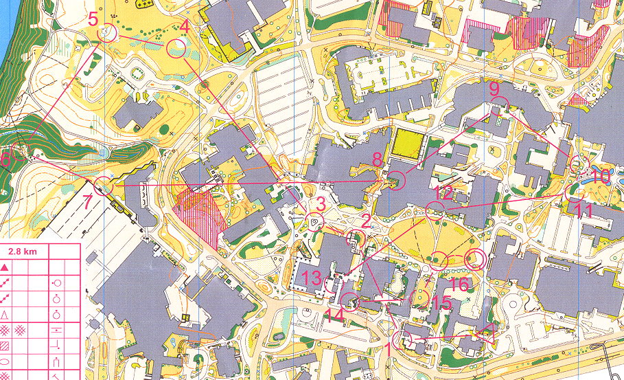
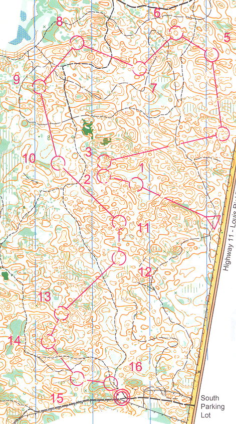
long map here
http://dl1.yukoncollege.yk.ca/brent/newsItems/view...
http://dl1.yukoncollege.yk.ca/brent/newsItems/view...
Aug 1, 2007 9:13 PM
#
Why is that area in the middle of the map (that the two long legs cross) out of bounds?
Aug 1, 2007 9:23 PM
#
It's not out of bounds (that would be parallel lines?) but marks a large area of freshly blown-down trees which I think was considered impenetrable by the organisers.
Aug 1, 2007 9:53 PM
#
Is there any support out there not to have the Canadians in the summer?
Aug 1, 2007 9:56 PM
#
I saw the purple cross-hatched area. Every tree was flattened. The tornado hit about 10 days before the meet, we were told. 200 meters in an hour would have been a good pace through there, I think.
Aug 1, 2007 10:00 PM
#
AZ:
That purple cross-hatch denotes "dangerous area" (at least that's what we course planners think). It is actually a seriously bad bit of blowdown. There is a smaller area of blowdown that we also marked, but mostly we just tried to change the courses so most legs went around the larger bits. That big bit though - holy crap was it brutal. I test ran the course Thursday to check if the old course was okay - and it took me about 45 minutes to get across that area, no portion of which was any fun whatsoever.
We think the storm picked up steam as it crossed the marsh and so caused that particularly huge area of devastation.
When we get RouteGadget working we will include the original courses as well as the modified courses.
We think the storm picked up steam as it crossed the marsh and so caused that particularly huge area of devastation.
When we get RouteGadget working we will include the original courses as well as the modified courses.
Aug 1, 2007 10:01 PM
#
Considering how bad the deadfall between 14 and 15 was which the organisers didn't mark as dangerous, I'm quite prepared to believe JJ's estimate.
Aug 1, 2007 10:47 PM
#
Its just interesting that the blowdown pattern perfectly negates any viable route through that gap between the marshes and no more.
That is, if someone asked how much OOB would you have to add and what shape should it be to just kill those route options, that would be it. Smart tornado.
That is, if someone asked how much OOB would you have to add and what shape should it be to just kill those route options, that would be it. Smart tornado.
Aug 1, 2007 10:48 PM
#
I got caught between 14 & 15 too. I reckon I lost about 3.5 min in less than 200m. I probably could have done it quicker but I was too tired.
Aug 2, 2007 2:09 AM
#
Hey, I went between the marshes, eddie. Skirted the S edge of the dangerous area, then off through the green. Not that it worked out all that well, of course...
Aug 2, 2007 10:05 PM
#
AZ:
RouteGadget is now working for the Middle distance events.
Please enter your routes.
The sprint event is also online, but currently identifies runners by their bib number. Please wait to draw your routes until I can figure out how to make that by name ;-)
Long distance event will come later - once I get the original courses included into the files.
http://rg.orienteering.ca
Aug 2, 2007 11:02 PM
#
AZ:
All events are in WinSplits, so you can analyze split times, see what position you were on in each let, etc.
http://85.89.72.58/winsplits/online/en/default.asp...
http://85.89.72.58/winsplits/online/en/default.asp...
Aug 3, 2007 1:09 PM
#
AZ:
The Long course is now in RouteGadget. Sorry - I was not able to figure out how to include the original courses, nor was I able to show the large area of blowdown.
The Middle course has been in RouteGadget for a while and a few courses have been drawn.
The Middle course has been in RouteGadget for a while and a few courses have been drawn.
Aug 4, 2007 9:06 PM
#
I think there was one other factor that made things a little difficult at the COC's - especially for us older and vision challenged orienteers. That was the very pale printing of the yellow for open areas. Combined with the sunshine on the map the pale yellow was almost impossible to see. With a darker printing more of us could have used the vegetation boundaries as route references and attack points. When they could be seen the vegetation boundaries were great. In their absence I decided to bail quickly to nearby trails and larger hills (there were a few) and use them as attack points.
Aug 6, 2007 6:22 PM
#
AZ:
As course planner ever since I first encountered Eb's Trails I have struggled to understand how fast people can move in this terrain. James Baker and I test ran some courses last fall - with no heat, no thick undergrowth, no dull yellow printing, and before the deadfall. Jim managed to hang-on for just over 10min/km but I completely blew up - hitting a massive 14min/km on a course that I had set and had recently hung all the 'controls'. Approximately 33% of my running time was in "lost" status :-)
Based on these test runs we estimated M21 times of about 7.5min/km - but we felt we were on shaky ground because of the large number of errors we (me in particular) had made. We felt certain that all competitors would be making mistakes - we just weren't sure how much time would be lost by the winners.
Admittedly, when we arrived at Eb's in July we realized the conditions were going to slow runners down, but we still didn't know how much time would be lost to errors.
My feeling is that even in perfect conditions TPKs will still be slower than one might expect.
I think - and I could easily be wrong - that this map is one of the most difficult in Canada, and perhaps it is the most difficult. I think the difficulty comes from the subtleness of the terrain, the higgledy-piggledy layout of the features (there is nothing much to be used for handrails or catching features, and no features run 'in the same direction' for any distance), and the lack of any fields or other major features to use for 'easy' navigation / relocation.
I look forward to the next event at Eb's (maybe the 2009 Westerns?, eh Saskatchewan OA? ;-) to see what we can do on our second crack at that terrain.
Aug 6, 2007 9:15 PM
#
I have a lot of difficulty w/ Canadians. They talk funny and all of their maps are too far north for me to drive to from Texas. And what's with trying to lay claim to the northwest passage? Hmmm? What a-boot that, I ask!
Aug 6, 2007 9:30 PM
#
feet:
I think you missed an 'eh?' or two there to get the stereotypes functioning properly there, Tom.
Aug 7, 2007 2:59 AM
#
In a recent conversation, well traveled Randy H respectfully rated this area as probably the most technically difficult area in North America, with the only possible exception being Mt Laurie(sp?), but definitely more difficult than big names like Pawtuckaway and Surebridge. Randy, if my quote is off, please clarify.
Aug 7, 2007 11:03 AM
#
I suppose it depends on how you define difficulty. I personally found Mt. Laurie and some terrain around Whitehorse more difficult, and I think of difficulty in terms of % time in contact. As for Eb's trails, I was in contact at a much higher percentage of the time than the other terrains -- its just that the penalizations were extremely high. Next time, I take the trail to #10, am less aggressive out of the start, and probably have a pretty decent run. So, how do you define difficult? Mt. Laurie and Whitehorse I have memories of booming pretty much every controls, but penalties not being as severe.
Aug 7, 2007 4:04 PM
#
The Eb's Trails terrain does have some similarities to Whitehorse in that it had a lot of negative topography w/ tons of hills and depressions. The difference being the hills and depressions in Whse are on steroids. That said I should have done much better but I think Randy got it exactly in that relocating at Eb's was much more difficult and my mistakes were HUGE.
This discussion thread is closed.