Discussion: ISSOM mapping elevated walkways
in: Orienteering; General
Feb 11, 2015 9:33 PM
#
Anybody have any good examples of mapping elevated walkways that cross above roads, parking lots, etc? I want to be able to show that:
1. You can enter / exit the walkways at either end, but not from the sides.
2. If you are running perpendicular to the walkway, you can freely pass underneath throughout its length.
1. You can enter / exit the walkways at either end, but not from the sides.
2. If you are running perpendicular to the walkway, you can freely pass underneath throughout its length.
Feb 11, 2015 9:52 PM
#
Map the walkway with bridge symbols on either edge, and fill with brown so it is obvious on that level it is runnable. The bridge symbol should let people know it is passable underneath too, but if that is on a route, then adding a purple crossing point there may make it clearer that is is passable both ways. I think a lot of the readability in this situation comes from the really fine details of how you draft it. Make sure the bridge ends are pulled far enough away from other objects so they stand out. Try and use the surrounding terrain to add context, i.e. with contours, so that the two levels look like different spaces.
Feb 11, 2015 10:46 PM
#
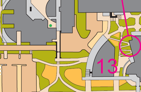
http://gvoc.whyjustrun.ca/courses/map/1743
(near controls #7 and #13)
(near controls #7 and #13)
Feb 11, 2015 10:48 PM
#
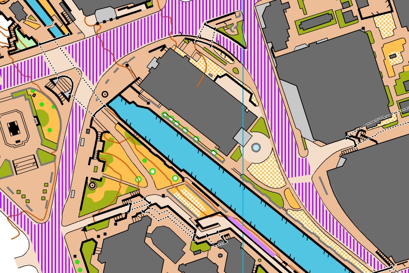
http://sprint.whyjustrun.ca/2013/maps/3long.gif
(one between controls #2 and #10. another between #13 and #14)
(one between controls #2 and #10. another between #13 and #14)
Feb 11, 2015 10:49 PM
#
http://sprint.whyjustrun.ca/2013/maps/2.gif
(everywhere on the OMG map)
(everywhere on the OMG map)
Feb 11, 2015 10:59 PM
#
On the second example there, the bridge between 2 and 10 has good separation of the symbol at the end of the bridge. Between 13 and 14, only one end of the bridge has obvious tags on it. I think a little more separation so that the tags are obvious is almost always more clear.
Feb 11, 2015 11:27 PM
#
I think a little more separation so that the tags are obvious is almost always more clear.
The one problem with the separation is that it sort of conveys that you can pass through that small gap, when in fact, you can't.
Obviously, it's a tradeoff. Bridge legibility vs. bridge accessibility.
The one problem with the separation is that it sort of conveys that you can pass through that small gap, when in fact, you can't.
Obviously, it's a tradeoff. Bridge legibility vs. bridge accessibility.
Feb 12, 2015 12:09 AM
#
I like the maps and solutions above.
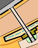
Here is a situation:

I think this one makes it pretty obvious that you can cross the walkway between the two building passages. But is it obvious enough that you can pass through the parking lot, or the drainage channel between the two uncrossable walls?
Here is a situation:
I think this one makes it pretty obvious that you can cross the walkway between the two building passages. But is it obvious enough that you can pass through the parking lot, or the drainage channel between the two uncrossable walls?
Feb 12, 2015 12:27 AM
#
The different shades of brown for vehicles vs pedestrians helps make it obvious that it's a bridge. I don't recall anyone ever having an issue with this bridge. I added the underpass symbol on the south side to make it even more obvious, but left it off the north side to avoid cluttering the thing too much.
Feb 12, 2015 12:43 AM
#
I would make a couple of changes to that example. Add some of the tunnel dashes under the bridge where lines would continue, and add the tags to the end of the bridge so it stands out more. I also use two shades of brown, one for pedestrian, and one for roads.

Feb 12, 2015 1:40 AM
#
Edwarddes, I like your cleaner bridge. I had tried putting the tunnel dashes at each end but that didn't seem to really highlight it (too long a span). I like how you put them where each linear feature crosses. I will have to exaggerate the width of the bridge a bit in order to get more than a single tunnel dash., but that might work.
Thanks all for great suggestions, and keep 'em coming!
Thanks all for great suggestions, and keep 'em coming!
Feb 12, 2015 1:44 AM
#
That looks like Curtin and particularly the Aus Champs event! You really should cut the control circle.
Feb 12, 2015 1:46 AM
#
I will have to exaggerate the width of the bridge a bit in order to get more than a single tunnel dash
Yeah, the tunnel symbol is remarkably clunky in most cases - very hard to use it properly for any 'tunnel' less than 30m long.
Feb 12, 2015 2:18 AM
#
edwarddes' example is exactly how I would draw it with one caveat. In particularly confusing areas I find it sometimes beneficial to add a thin white border around both the bridge and tunnel symbols to highlight them slightly.
You can see how this works in different scenarios on my map of downtown Ottawa. I find it's helpful when there are lots of other black symbols and features around - it shown the gaps between symbols while also making it clear that you can't physically go through the gap.
Click on the image to see it full size.
Feb 12, 2015 2:33 AM
#
Nice, Canadian. I know that spot! Would have loved to have had the full map when we visited there at NAOC!
Feb 12, 2015 2:37 AM
#
It's a super cool spot for orienteering. It's too bad that the renovated National Arts Centre won't be nearly as good for orienteering.
Feb 12, 2015 4:18 AM
#
I like the white outline of the bridge symbol when touching uncrossable walls. Both legible and understandable.
It's also weird to see a map using the lighter brown for vehicular and darker for pedestrian. The Whistler and Vancouver maps are the other way 'round, which is what I did for my ISSOM map last year (I actually used 3 different shades of brown because it was especially complex).
I know vechicular vs pedestrian is not in ISSOM, but I'm wondering how many sprint maps out there use different shades of brown (within spec), and which variety is more prevalent.
Feb 12, 2015 4:31 AM
#
Juffy uses light brown for pedestrian and dark brown for vehicular and I tend to follow his example when drawing our Metro Series maps, which are not ISSOM compliant.
It tends to get confusing when using the same brown for both, as we discovered at one of our sprint series events late last year.
It tends to get confusing when using the same brown for both, as we discovered at one of our sprint series events late last year.
Feb 12, 2015 5:05 AM
#
Yeah, I'm a big fan of the two-brown technique - while I always use the darker one for vehicular, after looking at Canadian's map above I'm not sure it matters that much. The point of using multiple browns is to say "yes, this is all paved area but this bit is noticeably different", and both arrangements work for that.
Feb 12, 2015 6:14 AM
#
@ tRicky - for the record: first WA sprint map with different vehicular/pedestrian browns.
Feb 12, 2015 9:31 AM
#
I didn't think it was necessary for STSW because I knew there would be almost no traffic at 3 events, and the one road likely to have traffic on the other map was marked out of bounds. Actually the early versions of two of the maps had it, but I changed them.
Feb 12, 2015 1:48 PM
#
It was more to do with clarity of terrain than whether we were going to be run over ;-)
Feb 12, 2015 5:22 PM
#
I've been thinking more about the original question and have a few additional proposals:
The bridge symbol should show the opening where you can go under. If this means having half the bridge bordered with impassable wall where it goes over the river and the other half (over land) shown with the bridge symbol so bit it. First and foremost, we're trying to show passibility. If there are two spots where you can go under the bridge show this with two sets of bridge symbols (this might not always work well??)
The tunnel symbol should show the impassable edges of the tunnel on the underneath layer. Again the most important thing is to show passibility vs impassibility. In Mike's example therefore I would not show the tunnel symbols at the edge of the road but only where the impassible walls cross under the bridge.
You can see how I've implemented this in my above map. It doesn't work quite so well for Mike's situation but it would look like this:
This discussion thread is closed.