Discussion: Just right or too much information
in: Orienteering; General
Jan 8, 2015 12:33 PM
#
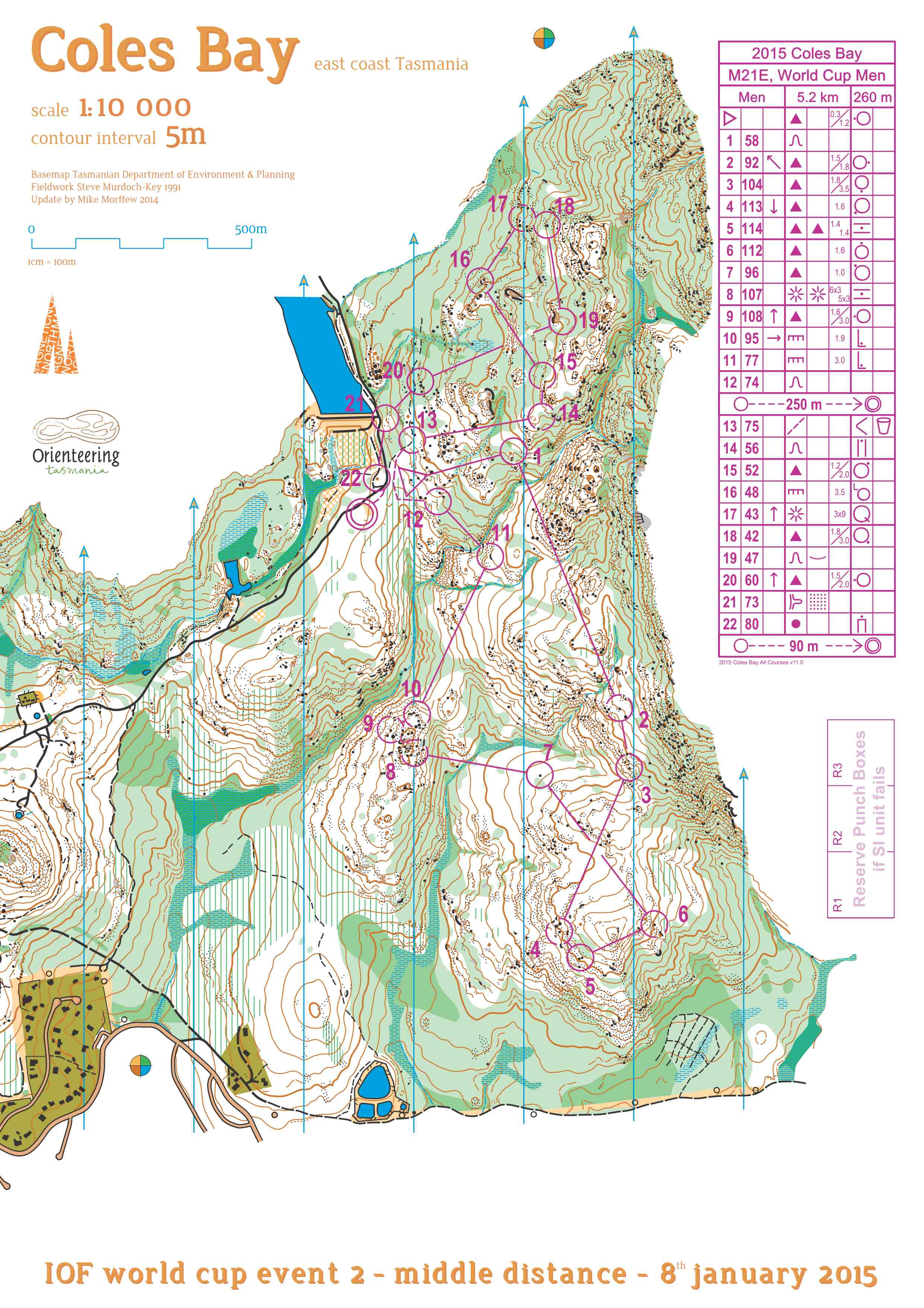
At a middle WC race 15 out of 22 controls on men's course had additional information in column F (dimensions). http://news.worldofo.com/wp-content/uploads/2015/0...
Is this just AU practice because our course setters normally use dimensions just in special cases to indicate the boulders which are really high or similar.
Normally we don't use additional info for boulder 1.0m high as in case of #7. If there is a boulder less than one meter than it probably would not be mapped. Athletes normally expect that boulders are at least that high.
I was also surprised to see heights written with precision of 0.1m (decimeters). Did they really measure the objects because there are so many heights for different boulders - 1.0, 1.2, 1.4, 1.5, 1.6, 1.8 ,1.9m that someone could think that they actually measured each one with meter. We normally use half of meter as the closest indication of height if it is really necessary to point out the special character of the feature.
Does Elite orienteering event really need this kind of precision?
Jan 8, 2015 12:51 PM
#
Looks like standard Australian practice to me. All controls on boulders will have heights, and they will all be to the nearest 10cm.
How is this bad for elite orienteers? Without looking, I doubt it breaks any rules.
It doesn't take any longer to read 1.3m than it does to read 1.5m, and having the height in the description as opposed to not having it at all helps to give you a clearer mental picture of what you are looking for.
How is this bad for elite orienteers? Without looking, I doubt it breaks any rules.
It doesn't take any longer to read 1.3m than it does to read 1.5m, and having the height in the description as opposed to not having it at all helps to give you a clearer mental picture of what you are looking for.
Jan 8, 2015 12:58 PM
#
Do you mean Yes "AU practice" or Yes "current official practice"? I must be a bit old fashioned because I was told that map reading in most cases should be enough to know and to find the feature you are looking for.
Jan 8, 2015 1:00 PM
#
If that was the case then elite orienteers wouldn't need to look at control descriptions at all?
Jan 8, 2015 1:06 PM
#
@How is this bad for elite orienteers?
I'm more or less just surprised and a little bit skeptical that course setter really measure all the point features with precision of 0.1m and EA did the same. For me it would be just fine with 1.5 and 2.0
I'm more or less just surprised and a little bit skeptical that course setter really measure all the point features with precision of 0.1m and EA did the same. For me it would be just fine with 1.5 and 2.0
Jan 8, 2015 1:08 PM
#
If that was the case then elite orienteers wouldn't need to look at control descriptions at all?
Right, like Hubmann says:
"In sprints I don't read the descriptions. Each glance at the control descriptions is one less glance at the map."
I don't think it matters whether there's a height in the box or whether it is 1.3 vs. 1.5 vs. 1.3472. Just because it's there doesn't mean people have to read it or do anything with the information, and the organizers can certainly never be faulted for providing the information.
Jan 8, 2015 1:16 PM
#
That loos like normal US practice as well, except that:
1) Heights would be only to the nearest 0.25 m.
2) Splits heights on a slope are used sometimes, but not widely.
3) Area of bare rock would almost never be shown.
1) Heights would be only to the nearest 0.25 m.
2) Splits heights on a slope are used sometimes, but not widely.
3) Area of bare rock would almost never be shown.
Jan 8, 2015 2:20 PM
#
Sprints are different to bush orienteering. I rarely look at descriptions in sprints but quite often do in the bush, usually to check the height of the rock feature!
In terms of Aus rock heights, typically if it's over 2m, it's only described to the nearest 1m, or it might go 2.0, 2.5, 3.0, 4.0, 5.0, etc. Anything taller than yourself is just big and 0.1m increments don't matter at that height!
In terms of Aus rock heights, typically if it's over 2m, it's only described to the nearest 1m, or it might go 2.0, 2.5, 3.0, 4.0, 5.0, etc. Anything taller than yourself is just big and 0.1m increments don't matter at that height!
Jan 8, 2015 3:43 PM
#
@0.1m increments don't matter at that height!
I also doubt that anyone can distinguish the difference between 1m and 1.1m boulder at competition speed or make an error just because of that. It is very unimportant info in most cases anyway. I've looked at control description guide and there is no guidance about 0.1m. I suppose it is up to course setter and space provided.
I also doubt that anyone can distinguish the difference between 1m and 1.1m boulder at competition speed or make an error just because of that. It is very unimportant info in most cases anyway. I've looked at control description guide and there is no guidance about 0.1m. I suppose it is up to course setter and space provided.
Jan 8, 2015 4:07 PM
#
It makes a difference when you're running through 1.0m high grass to find the 1.1m boulder!
Jan 8, 2015 4:27 PM
#
Nice try. Probably your o-technique change when grass grow to 1.1m :) I suppose AU grass is not green and boulders are not ...
Jan 8, 2015 6:44 PM
#
tRicky, wouldn't you need to know the grass was 1.0m, not 1.1m, high as well in order for it to make a difference to your technique? Do you always run with a tape measure in your pocket so you can measure the height of the grass?
Jan 8, 2015 10:27 PM
#
@Kofols. Your question suggests you have grown accustomed to an informal variation of the IOF rules. The IOF event rules say that control descriptions will be according to the IOF control description rules. The IOF control description rules say that dimensions will be provided when the map feature is symbolic rather than to scale. Rock features are certainly symbolic. It is Australian practice to provide dimensions for rock features- boulders, boulder clusters, boulder fields, rocky ground, bare rock. There is a certain ambiguity in this rule. Roads are symbolic but are never given dimensions. In Australia we do not give high points in granite but a strict reading of this rule suggests we should. Perhaps its a characteristic of living in an isolated orienteering community, but I suspect we are more likely to slavishly adhere to the IOF rules than some other federations (eg SOFT). 1 dcm accuracy is perhaps overdoing it, but when you have one international carnival every decade, there is an understandable tendency to want to get everything 'just right'. You never know, the setter may well have had a tape measure. ;-)
Jan 8, 2015 10:30 PM
#
Also, I suspect that some sprint competitors might have regretted not reading the control descriptions in the Launceston final.
Jan 9, 2015 10:42 AM
#
@there is an understandable tendency to want to get everything 'just right'.
Every organizer has exactly the same goal so this is the only way we can learn from each other. There are rules and there is tradition, best practice and people like me who are interested in these differences. That's way we have IOF rules to know what should be "just right" so we can all follow the same rules. International standards in any sport are always put to the test at every international event. I was not aware of AU practice till now. It seems you have slightly different practice than US and slightly different than our practice. Is this important or not for athletes? Should we stay as it is now and use "local tradition" for dimensions?
@living in an isolated orienteering community
That must be wrong. Many of AU's or NZL's are traveling abroad, etc. You have your members in IOF, you have developed the sport, you are hosting WC events, you have world junior and senior champions.....I believe that we're more isolated here in the EU as only few have real interest in international orienteering. Yes, we are closer to major events but we are years behind you.
@to provide dimensions for rock features
I believe it is "just right". I feel that it is much safer for athletes and not that much of additional work. We don't use this practice because of "different practice" and nobody ever have complained about it. Like I said, we are more isolated.
@1 dcm accuracy is perhaps overdoing it
Probably, but let's wait for new ISOM.
Jan 9, 2015 12:19 PM
#
Providing more information on the control descriptions is harmless. I'll normally look and see "boulder", and the additional stuff doesn't interfere. It's not at all like putting extra detail on the map.
Jan 9, 2015 12:26 PM
#
@kofols. I ran the OOCup last year. It may not have been an IOF event, but it certainly had a very international feel. I suspect that, elite events aside, it was far more cosmopolitan than our own national events. That aside, most of the arrangements felt very familiar, so I guess the IOF structure has fostered a common culture.
Jan 9, 2015 1:00 PM
#
Yes, OOcup organizer is up to date. They do their stuff by high standards.
Same practice as you mentioned and I believe you enjoyed.
Others try to follow and do their job each year better and better.
I believe that this is just one of many small improvements we should be aware off. Sometimes organizers need to see foreign example before understanding what it is the issue in first place. OOcup is too big and not part of the (club, federation) and that is way some "practice" is probably lost along the way.
Jan 9, 2015 1:03 PM
#
I find the amount of decimals / accuracy of boulder's height quite irrelevant compared to the fact we appear not to have decided yet should maps clearly reveal the side of the fence control is located, or must it be seen only by looking at control descriptions.
If we decided description gimmicks are part of the sport, fine. Then everybody would know to check descriptions. If we decide get rid of these gimmicks and say map should always clearly reveal things like these, and if you can't tell the side clearly enough with map you need to move the control, that would be fine too (IMHO even better). But I don't think the current unclear state isn't quite the way this should be.
If we decided description gimmicks are part of the sport, fine. Then everybody would know to check descriptions. If we decide get rid of these gimmicks and say map should always clearly reveal things like these, and if you can't tell the side clearly enough with map you need to move the control, that would be fine too (IMHO even better). But I don't think the current unclear state isn't quite the way this should be.
Jan 9, 2015 1:42 PM
#
kofols, I would say Aus & NZ are far more isolated than any European country. The fact that so many of us travel is because we have to in order to get to the big events. Europeans don't have to travel to events in our part of the world because they have so many to choose from at home. Given that a national event in Aus attracts somewhere around 700-800 people whereas a big event in Europe attracts 10,000+ seems to support this.
On a slightly related topic (although unrelated to 1.6m boulders), I was checking through the results of the last WMG held in Aus in 2009 and noticed the big difference in traveling competitors. In the two sports I was interested in - cycling and orienteering - roughly 95% of the cycling participants came from the home country whereas for orienteering, this number dropped significantly to something like 20-30%, with the remainder from all over the world. Are orienteers more willing to travel than those from other sports? I would say yes and the main reason is for variety of terrain (i.e. we appear to have more boulders down our way than you do in Europe, judging from your comments, so have to specify rock dimensions to the nearest 0.1m :-) ) whereas for a road bike race, well you can do that anywhere.
On a slightly related topic (although unrelated to 1.6m boulders), I was checking through the results of the last WMG held in Aus in 2009 and noticed the big difference in traveling competitors. In the two sports I was interested in - cycling and orienteering - roughly 95% of the cycling participants came from the home country whereas for orienteering, this number dropped significantly to something like 20-30%, with the remainder from all over the world. Are orienteers more willing to travel than those from other sports? I would say yes and the main reason is for variety of terrain (i.e. we appear to have more boulders down our way than you do in Europe, judging from your comments, so have to specify rock dimensions to the nearest 0.1m :-) ) whereas for a road bike race, well you can do that anywhere.
Jan 9, 2015 1:49 PM
#
Jagge - I probably agree with your point that it should be clear from the map which side of the feature a control is on in terms of which I would prefer to use, but it has never been that way has it? It doesn't make as huge a difference in bush races most of the time (unless you run past on the wrong side of a boulder and don't see the control flag).
So I disagree with the "control description gimmicks" label. Have they not always been part of the deal and designed to remove any ambiguity from the map / use of point features? I rarely check control descriptions on sprint races, but make a point of it if I am not 100% sure which side of a feature I am looking for (found out the hard way a couple of times years ago).
If current mapping practice is what it is, then perhaps people need to use the skill set / resources they are given to perform successfully at present. The control that caused the most trouble in the WC Sprint is one I would have been checking the description for.
Jan 9, 2015 1:56 PM
#
I find knowing the height very useful in our local western australian granite terrain where there are often many boulders peeking out of the scrub mapped with the requisite identical boulder symbol. Knowing that my intended boulder is - say - 1.8m as opposed to 1.2m helps my confidence, irrespective of whether I'm navigating cleanly or not. Allows more simplification I guess. Having said that, I only glance to that column if the control zone is littered with boulder symbols.
Jan 9, 2015 2:23 PM
#
In traditional O there has been cases with cliff, on top. It has always been seen as a gimmick.
In the men's race there was at least two controls with plenty of room to place ring the way it reveals the side clearly, but setter did not make it, apparently on purpose to create additional challenge. I believe tricks like that are seen as a part of the sport there. And based on what Hubmann stated I'd say the it is not in Switzerland. Are tricks like that part of the sport, and are planners supposed to try to lure athletes with tricks like that even if there is easy way to tell it clearly - I just would like to get an answer to that. Maybe that is the way of the future for sprints.
In the men's race there was at least two controls with plenty of room to place ring the way it reveals the side clearly, but setter did not make it, apparently on purpose to create additional challenge. I believe tricks like that are seen as a part of the sport there. And based on what Hubmann stated I'd say the it is not in Switzerland. Are tricks like that part of the sport, and are planners supposed to try to lure athletes with tricks like that even if there is easy way to tell it clearly - I just would like to get an answer to that. Maybe that is the way of the future for sprints.
Jan 9, 2015 2:27 PM
#
@national event in Aus attracts somewhere around 700-800 people whereas a big event in Europe attracts 10,000+ seems to support this.
This is off topic and since we don't have official numbers I can only say that Sweden and Nordic countries are just part of +30 EU countries. You can't use SWE as EU example because Nordic countries are in professional league. Compare rest of EU with AUS and you will see that you are doing just fine. We non-scandinavian EU countries are looking with different glasses. For most of us SWE is also very far. I know you would be most glad to travel just 2000km but if you want to understand the EU orienteering political map you need to look with through that glasses. It would easier if IOF gather basic info (# of registered athletes, #events, biggest national event, #officials, #employees, budget, etc).
My definition of "isolation" is more or less hidden in these numbers. e.g. What is the minimum number of participants per event when you could call the sport has a chance to be sustainable and how many of these sustainable events AUS clubs hosted in last year? I'm not up to date but last year SLO clubs hosted none or very few events with 200, 300 participants or more. Sweden is far far far away but we are glad that we've become one of EU destination for many orienteers.
Jan 9, 2015 2:45 PM
#
That must be wrong. Many of AU's or NZL's are traveling abroad, etc. You have your members in IOF, you have developed the sport, you are hosting WC events, you have world junior and senior champions
There is (almost definitely) a disconnect between the people doing the travelling and the people measuring the boulders. Of the people who set/controlled the last national carnival in my state, I don't think a single one has ever been a national rep, and if they travel to overseas events they're certainly not running elites.
So how on earth would we know what the convention is in Europe? Oh, right - we follow the IOF regs, and we do it as close as we can on the assumption that everyone else is doing it that way too. I think it's quite amusing, and instructive, that someone finds descriptions that are fully compliant (or as close as humanly possible) with IOF regs worthy of comment.
Jan 9, 2015 3:50 PM
#
bubo:
Slightly off topic but that´s AP for you...
Anyone remember the highly debated 'control description gimmick' called MicrO they tried to get into WOC a few years ago (2006)?
There part of the game was fooling the competitors by putting false controls in the area making it extremely vital to read control descriptions.
It wasn´t mature then and the debate has died out - as has the discipline (as far as I know) since noone has found it interesting enough to keep developing and to let it mature.
Jan 9, 2015 10:05 PM
#
@Juffy. I think you just demonstrated that WA orienteers are even more isolated that Eastern State Australian orienteers.
Jan 10, 2015 2:31 PM
#
This is off topic
I don't know, the topic is "Just right or too much information". You're really leaving it wide open there ;-)
I'd be very surprised if Western Australia hosted any events this year with any more than about 130 participants. Those 130 are pretty isolated from events on the other side of the country though!
Jan 11, 2015 6:40 AM
#
To me it looks like isolation is not a bad thing what it comes to arranging WC races. And Tasmania may be enjoying quite optimal amount of isolation.
Jan 11, 2015 10:05 AM
#
Tasmanians know what they are doing :) Also, they have A LOT of boulders on their maps. And currently, the IOF requirement is that the control circle must be centred on the centre of the object on the map - as the space on the map covered by that object may be greater than the area it covers on the ground - and not off to one side even if the flag is on that side.
@Fletch: absolutely right. The description was fence, southern-facing inside corner. Those who ran below and then had to come up and around ran to the northern facing corner. I watched Simon read the description, scout the ground in front of him, and then run high to the correct corner. Those who merely read the map, did not.
Also, if I can't see over a boulder then I know it's at least 1.4m high...
Jan 11, 2015 11:40 AM
#
the IOF requirement is that the control circle must be centred on the centre of the object on the map
Which is insane. Nobody puts the circle for a field corner in the middle of the field: heck, it may not even be on the map!
I commend control 81 in the sprint, on the south side of the wall. Instead of calling it that, they used "canopy" which is a good choice good because:
a) the canopy is only on one side of the wall.
b) the position of the circle can make it clear form the map where to go.
They also had the good sense not to centre the control circle on the centre of the object. That would have it stuck up the wrong passageway (as tends to happen to the anally retentive...).
PS Top tip for WOC2015: if you can't see over the boulder then you know you've fallen over.

Jan 11, 2015 12:14 PM
#
Which is insane. Nobody puts the circle for a field corner in the middle of the field: heck, it may not even be on the map!
I believe it applies to point features, not area features. Point features are typically larger than the feature they represent so to put it on one side would mean the flag is not in the centre of the circle.
Jim, can you have an end of a canopy? Was it narrow?
I believe it applies to point features, not area features. Point features are typically larger than the feature they represent so to put it on one side would mean the flag is not in the centre of the circle.
Jim, can you have an end of a canopy? Was it narrow?
Jan 11, 2015 12:16 PM
#
Without looking at the spec, I'll suggest that the reasonable interpretation is that the circle should be centered on the feature when it's a point feature. (There's still probably enough ambiguity in terms of what qualifies as point feature that the argument can continue -- carry on.
(edit -- Should I be concerned when my thoughts so closely parallel those of tRicky? Maybe we're actually the same person; certainly nobody has ever seen the two of us together...)
(edit -- Should I be concerned when my thoughts so closely parallel those of tRicky? Maybe we're actually the same person; certainly nobody has ever seen the two of us together...)

Jan 11, 2015 3:13 PM
#
What is the official tolerance for positioning the flag on the ground out of circle centre at sprint, middle, long or TrailO? The correct position can be slightly different at sprint or TrailO with same control description.
Jan 11, 2015 5:25 PM
#
@tricky "I believe"
@jjcote "Without looking at the spec, I"
The spec says "The centre of the circle shows the precise position of the feature". Which makes senses for any feature if you take the control "feature" to include the side (i.e. you centre the circle to the side of the symbol). Anything else requires you to believe in extra rules which don't exist (e.g. only applies to point features, only applies in Tasmania, center is different from centre etc.)
@kofols : ISOM requires us to shift symbols by up to 4m to maintain the minimum separation for clarity. So it wouldn't be sensible to require "precise position" to be better than that.
I'm with kofols and Hubmann on this one. If centering the circle on the correct side best enables the athlete to get the required information from the map, you should do so.
Jan 11, 2015 6:12 PM
#
What about over/under features like a bridge? Center of circle is same.
Jan 11, 2015 6:59 PM
#
Pink Socks, I have once been told that there is a rule that says you can't place a control such that if you are in the right place but on the wrong level you can't see it. In other words the control can't be placed under or on top of a bridge. It can be place at the end of the bridge. Alternatively if you can't actually get to the top of the bridge then you could place it underneath. \
That said, I just did a quick search for the above rule and couldn't find it. In the process I found rule 3.4.2 "Fairness of legs" (in the Jan 2015 foot-o rules) which interestingly states
"No leg should contain route choices giving any advantage or disadvantage
which cannot be foreseen from the map by a competitor under competitive
conditions."
That could be interpreted such that having a circle centred on the corner of the wall violates the rule. It very clearly affects route choice and should therefore be clear on the map.
Jan 11, 2015 8:08 PM
#
If centering the circle on the correct side best enables the athlete to get the required information from the map, you should do so.
It doesn't though. It makes it hard to know (in a feature-rich area) what feature you are looking for at all (eg boulder or re-entrant?). And for normal-sized boulders say, the circle would end up being centred 10m away from the flag location, hardly helpful. It makes control descriptions essential rather than merely useful. I've run championship middle/long races where this was done, and it's terrible.
It doesn't though. It makes it hard to know (in a feature-rich area) what feature you are looking for at all (eg boulder or re-entrant?). And for normal-sized boulders say, the circle would end up being centred 10m away from the flag location, hardly helpful. It makes control descriptions essential rather than merely useful. I've run championship middle/long races where this was done, and it's terrible.
Jan 11, 2015 8:20 PM
#
I'll suggest that whoever composed that rule didn't think it through in as much detail as it's being subjected to here, and the actual intent is not "position of the feature", but rather "position of the control marker". Bear in mind that in the case of a symbol like a large boulder, centering the circle on the position of the control marker does not mean centering it on the edge of (or outside) the black dot. It means centering it on where the marker is, which is typically inside the black dot, in other words, in a location that's essentially indistinguishable from the center of the dot. To find out which side, you need to look at the control descriptions. For sprint courses where the control might be inside the corner of an uncrossable fence, it would therefore be advisable to place the control far enough inside that the circle ends up visibly shifted. There really shouldn't be any complaints about such a practice.
Jan 11, 2015 8:31 PM
#
rm:
To me, the most readable, useful and pleasant would be to have whole numbers of meters for boulder height...5, 4, 3, etc....without any decimal point...except that it's worth having, say, 1.5m, 0.7m and 0.5m. 1.5m is (for any given shape) about twice the cross-sectional area in the orienteer's field of view as a 1m boulder (of the same shape), and about half that of a two meter boulder. Similarly 0.7m is about half the "visual target" of a one meter boulder, and 0.5m about half that of 0.7m. (And yes, I've been on courses with boulders described (sometimes generously) as that small.) Rounding up a half meter boulder to one meter would be giving a significantly misleading measure of the object's visual size (by a factor of four). That 0.5 in the size column is a useful red flag to the orienteer to look for something semi-moveable.
In terms of how much detail in general to put in descriptions, I find the most pleasing, as an orienteer, to be "as simple as possible, but no simpler". Occasionally control locations truly require something(s) in nearly every column, but most controls can be described with far less, sometimes as little as control number, control code, and feature (e.g., full contour knoll, or even reentrant or clearing). One should definitely be able to navigate precisely to the location using the map and the description, without hunting around once in the described place, but I think that course setters sometimes fear that they need to provide more precision in order to accomplish that than in fact they do. Some reentrants are big enough that "upper end" or "lower end" is necessary for the orienteer to navigate without searching once there, but some are small enough that "reentrant" (if I recall the rules correctly a feature without a side, edge, part or corner specified means middle of), with nothing further, is completely adequate. In fact, sometimes the middle of the reentrant is more distinct than the upper part (which quite often dwindles out slowly into nothingness rather than being a distinct location) or lower part (which sometimes broadens and flattens slowly into nothingness, or is made vague by a "delta" of washed-down soil). A friend once joked that if so-and-so was course setting and described a control as "reentrant, upper part", then one should forget all about the reentrant and head for the saddle. Other course setters place the same control much further down, where the reentrant is more distinctly a reentrant. I suspect that, in fear of criticism for lack of precision, some course setters use "reentrant, upper part", leading in fact to a slight hunt through 50 meters of dwindling reentranthood, rather than being in fact more precise by using "reentrant", and placing the control in the easily findable center of the reentrant where it's also most pronounced. I'll admit that I once visited a control described simply as reentrant, in which the reentrant was wider than the circle and several times its length. That's too vague...but, in fact, even that didn't cost me more than a slight detour on approach. But if the reentrant fits within the circle, then "reentrant" may often be enough, and may be better than a vaguer upper or lower part. Another sometimes case of ostensibly more precise, but in fact more of a hunt, is using corner/edge/side for a clearing small enough to fit in the circle. Going to the center of a small clearing is almost always less of a hunt than trying to find a corner or edge of such a feature. My reentrant and clearing examples may be slightly controversial...the habits of "upper part" and "edge" are strong...but over the decades I've come increasingly to think that lots of such controls would be better with fewer modifiers.
OK, enough pot stirring for one day. Time for a walk before the snow accumulates.
Jan 11, 2015 11:30 PM
#
rm:
Hmm, that reentrant seems about twice as long as the circle is across...not really the size of reentrant that I had in mind for omitting further description. (And, the circle isn't centered on the middle of the reentrant, but rather some place along it.) Looking at the map, conceivably "reentrant bend" might have worked (depending how it looks in the terrain). Granted, the attack from the nearest cliff to the west is likely to bullseye one on the control, but the circle and description should disambiguate where the control is regardless of the route taken to it.
Jan 12, 2015 1:52 AM
#
However, in a kofols display of 'reading the rules':
19.3
The flag shall be hung at the feature indicated on the map in accordance with the control description. The flag shall be visible to competitors when they can see the described position.
This implies to me that you centre the circle on the feature (even if it's a point feature) and then use the description to indicate which side of the feature.
As JJ points out above, a boulder on a 1:15,000 map is 0.5mm across so this works out to 7.5m on the ground. Is the boulder really 7.5m across? Highly unlikely, and if it was you'd use the 'large boulder' symbol. If you stick the circle off to one side, it is no longer centred on the flag location, unless you put the flag away from the boulder.
Jan 12, 2015 2:08 AM
#
Also this:
18.1
The precise location of the controls shall be defined by control descriptions.
18.1
The precise location of the controls shall be defined by control descriptions.
Jan 12, 2015 9:23 AM
#
Is the boulder really 7.5m across
On a 1:15 map, two boulders also have 7.5m of "white space" between them for legibility. But do all boulders conveniently place themselves 15m apart? Of course not. We shift the symbol for clarity.
So any argument based on "better than 10m precision in the map" is nonsense.
On a 1:15 map, two boulders also have 7.5m of "white space" between them for legibility. But do all boulders conveniently place themselves 15m apart? Of course not. We shift the symbol for clarity.
So any argument based on "better than 10m precision in the map" is nonsense.
Jan 12, 2015 12:11 PM
#
@JimBaker - 0.7m is large! I've had a course with an 0.3m boulder (admittedly about 25-30 years ago - said feature wouldn't be on any more modern re-map of the area).
Jan 12, 2015 12:41 PM
#
An old informative thread Centre of the control circle where should it be?
"At sprint events a control might be on one side of an impassable fence or wall - it is appropriate I think to offset the circle to clearly show which side so as not to trap competitors."
Agree, a nice touch.
+++
At least for above #13 I think the answer is clear, although the spec and rules can be interpreted in both ways.
Jan 12, 2015 12:53 PM
#
Is dot the best possible symbol for boulder and knoll?
...I prefer to see centered the flag location because my main purpose is to find the best way to the control point and not just to the feature and then realizing that control is on the other side of the wall (e.g. 0.5m). The rules are not clear here either as we don't have clear guidance how we could use circle for each point and area feature. In the spec there are many examples where the circle is centered on the feature and on the flag location so rules can't be interpreted just one way; but I must admit that I haven't seen any map with circle offset on boulder & knoll. If there are examples and comments I would be glad to read it. We might also try to test other symbols for boulder and knoll which might give better result than dot. Maybe we could experiment with PacMan as I still think that the goal should be "to find the control point only with map reading". It would be very intuitive to know on which side of the boulder is the flag.
...I prefer to see centered the flag location because my main purpose is to find the best way to the control point and not just to the feature and then realizing that control is on the other side of the wall (e.g. 0.5m). The rules are not clear here either as we don't have clear guidance how we could use circle for each point and area feature. In the spec there are many examples where the circle is centered on the feature and on the flag location so rules can't be interpreted just one way; but I must admit that I haven't seen any map with circle offset on boulder & knoll. If there are examples and comments I would be glad to read it. We might also try to test other symbols for boulder and knoll which might give better result than dot. Maybe we could experiment with PacMan as I still think that the goal should be "to find the control point only with map reading". It would be very intuitive to know on which side of the boulder is the flag.
Jan 12, 2015 1:10 PM
#
So any argument based on "better than 10m precision in the map" is nonsense.
So I take it it's a case of 'disagree with me and you're wrong'.
So I take it it's a case of 'disagree with me and you're wrong'.
Jan 12, 2015 2:39 PM
#
If there are examples and comments I would be glad to read it.
The challenge should be course and terrain. Maps should not be the challenge. Maps should help athlete, make athletes life easier. Mapper should map the essential stuff, not trying to add challenge by mapping too much making it hard to read and hard to figure out what are the essential and prominent features.
Same applies to course settings. The objective is to make it as clear as possible and give the essential information athlete needs, not trying to create additional challenge. It is not really that difficult to figure out what this means in practise. For example, when control is a dot knoll or a boulder or a tiny marsh, it not that difficult or time consuming to go the the other side of the boulder, and the side does not have much affect on route choice. But there may be other objects close and with spot colour offset printing the ring may end up slightly off, so safest is centering the ring to the dot. It would still point the right boulder even if printing is slightly off. Safest, clearest and less confusing. If it is again marsh but now marsh gets larger, at one point it gets more intuitive and gives more value to the athlete if ring is centered to the side the marsh flag is located. Centering it to the center of the marsh gets more and more missleading when marsh gets bigger and on the other hand the tiny printing offset error will make less harm because marsh object is bigger. Same with sprint courses. Course printing should help athlete, not add challenge. So what is essential at #13? Is it showing the distance from the fence, telling it is at the very very end of the narrow canopy, so athletes would know to run hard all the way to the very end of the canopy? That could have be the case if the area behind the fence been OOB. It would have been be obvious the flag is at this side of the fence, so the right story to tell is it's at the very end. But now it wasn't the case. The essential information to tell to athletes was telling it is a canopy and it is this side of the fence. Telling distance from the very end is less essential compared to this fence side thing - everyone would enter the control from the same direction anyway and no-one would overshoot the flag in the canopy.
(But that's just my personal opinion, it is not told like that in any document or rule. If community thinks CS traps are really cool and majority asks for more, that's fine by me. I just would not bother to participate that often.)
Jan 12, 2015 3:52 PM
#
Coming all the way back to the original question ...
Does Elite orienteering event really need this kind of precision?
If the information was really needed, then if it were wrong you'd have to void the course. It's inconceivable that you'd void the course because a boulder was 1.8m rather than the advertised 1.6m. So it seems obvious that 0.1m precision it isn't necessary.
On the other hand, as long as the organisers are going to take a hard line against pedantic competitors taking the numbers seriously, it's hard to see why there's a problem. And it's certainly better than having no height at all.
Jan 12, 2015 3:58 PM
#
@Jagge
I totally agree. I'm just wondering how sensible would be to change graphic implementation for boulder and knoll. To change dot into pacman dot. Circle would still be centered on feature like today but with one difference; athletes could get more information also out of the map and not just from the control description. Like you said "Maps should help athlete, make athletes life easier."
#13 But you probably can't just use OOB on the map without putting the tape on the ground. Also, why to ruin this trap - route choice? If athlete make a mistake it's his mistake as long the circle clearly show on which side of the fence/wall is the control point. You wrote "with plenty of room to place ring the way it reveals the side clearly, but setter did not make it" so I assume that in the event that you were a SEA you would also support the solution "to offset the circle to clearly show which side".
Jan 12, 2015 6:30 PM
#
@kofols The reason I thought #13 was good controlling is that the control point was called "canopy" not "wall". So its obvious from the main part of the description which side its on, and the circle should be centred on the south side of the wall*, even by those who insist that there's some unwritten special rule about point features and that walls are point features.
* Sadly, the picture looks like it's centred on the uncrossible wall. Since the wall symbol is 2m across at 1:5000, it often means the control is somewhere that the map says is illegal to go.
* Sadly, the picture looks like it's centred on the uncrossible wall. Since the wall symbol is 2m across at 1:5000, it often means the control is somewhere that the map says is illegal to go.
Jan 12, 2015 7:28 PM
#
@So its obvious from the main part of the description which side its on
Description should not be a major and the decisive factor which both agree. I'm just saying that only map reading was not enough to know that even that this was obvious from description. Your option would also be fine which would give same result as saying "to offset the circle to clearly show which side". If we would have this case; could control stay on the same location with same description? That's way I asked (not very clearly) how far away from the circle center we could put the flag to say it is within the rules and control is not misplaced? I didn't look in the rules for that but in previous post you probably misunderstood me because you said 4m (relevant for mapped objects if I correctly understand you).
EDIT e.g. if you have an object 2x2m and description says west side but the control in on north side? or same situation but the object is 10x10m?
Jan 12, 2015 7:55 PM
#
Why not move the control a few meters to the SE so that the circle can be shifted a bit and the description remain the same (or changed to "NW part")?
Jan 13, 2015 1:01 AM
#
Agree with the above. It's not obvious just from the map but then control descriptions have been a part of orienteering forever (well as long as I've been involved anyway, which is not all that long) and they are included in the rules so should be utilised.
However, in the case of an impassable feature (not a point feature as I've been referring to in previous posts), I think it should be clear from the map.
However, in the case of an impassable feature (not a point feature as I've been referring to in previous posts), I think it should be clear from the map.
Jan 13, 2015 4:17 AM
#
@graeme - to my eyes it looks like the centre of the circle is on the corner of the canopy, not on the wall, but if it wasn't magnified and I was running, I doubt I could tell the difference. I've had several competitions where I was sure the circle was centred on one particular spot, only to find out when I had finished and got some oxygen back in the system that I was completely wrong.
I understand that people want to be able to get all the information that they want from the map, but as much as they might want to, all the discussion above proves how difficult that can be.
With control descriptions and a map, all the necessary information is already provided. I don't see why athletes are so reluctant to use it and then get upset when they choose not to.
Jan 13, 2015 4:36 AM
#
that control was one of the few I checked the description for, and it paid off. don't think I actually noticed the symbol was canopy though - just saw the end of and realised that meant it had to be inside
Jan 13, 2015 5:36 AM
#
AZ:
I always wonder about copying from ski orienteering - and putting a dot in the middle of the circle at the spot where the control is. Especially in Sprint I think this might be a good idea. Eliminates pretty much the need for those control descriptions and takes away the nonsense of "which side of the impassable wall is the control on"
Jan 13, 2015 5:59 AM
#
AZ:
Wouldn't obscure the boulders - the dot would be beside it on the appropriate side. Same with a wall.
I suppose there is some feature that it would be on (maybe?). Or that it would obscure a gap between features.
But I don't know how often that would happen or how big a problem it would be
I suppose there is some feature that it would be on (maybe?). Or that it would obscure a gap between features.
But I don't know how often that would happen or how big a problem it would be
Jan 13, 2015 6:11 AM
#
It would happen because the circle is centered on the damned feature!!!
Circle dot also gets used in MTBO on complex maps but then you are only dealing with tracks.
Circle dot also gets used in MTBO on complex maps but then you are only dealing with tracks.
Jan 13, 2015 6:26 AM
#
AZ:
Well okay - so two rules would have to change ;-) The dot would indicate the position of the flag, not the feature.
I don't know - I haven't really thought this through to all situations (eg: in a pit). But I feel it is going to be as good as no dot most of the time and much better some times - and okay probably worse sometimes too. I just wonder whether it would be better more often than worse.
I don't know - I haven't really thought this through to all situations (eg: in a pit). But I feel it is going to be as good as no dot most of the time and much better some times - and okay probably worse sometimes too. I just wonder whether it would be better more often than worse.
Jan 13, 2015 7:05 AM
#
We've often done that in street-o in london when there isn't really much of a feature. Could see it being useful in relays, but then if you had the dots, the control number and the code on the map it'd be pretty cluttered.
Jan 13, 2015 9:11 AM
#
With control descriptions and a map, all the necessary information is already provided. I don't see why athletes are so reluctant to use it and then get upset when they choose not to.
Key question. I think the answer is that we have obsolete rules from ISOM applied to sprint.
For an ISOM point feature, you dont really need to check which side its on: either you see the flag first, or you go round the back. And if you're looking for 1.4m boulder, W side, you're still going to check out the 1.6m boulder S, side in the circle. It's helpful to know if it's a huge feature you'll see from a long way off.
But in ISSOM, the description can be critical - wrong side of a wall at 13 may cost you the race.
In the UK, some planners regard interpreting complicated descriptions as part of the technical challenge of orienteering. The extreme line is that if you don't fully exploit the technical possibilities of map AND descriptions, then the course isn't fully technical.
Others disagree, believing there should be an asymmetry where the mapreading should be "as hard as possible" while communicating where the flag is should be "as simple as possible". That's why they get upset when the challenge is transferred from map to descriptions.
PS I'm coming at this from the view of a course setter trying to make it as good as possible, not an athlete looking to protest.
PPS I now increasingly use the CDs in ISSOM, because my eyesight has become too poor to see the map. But that's another story.
Jan 13, 2015 10:31 AM
#
Iirc, the mistake 1.40 into here was due (in part) to not having read the control description. https://www.youtube.com/watch?v=zhFLXyZHjw8
Jan 13, 2015 1:13 PM
#
I have been thinking the same as AZ, but also dropping the concept of control feature altogether. Flag would be where the dot is, simple as that. And dot could be placed anywhere. Then dot would not obscure the feature because there would be no feature. CD would be just a list of codes - if needed at all.
https://www.facebook.com/177518995597572/photos/a....
https://www.facebook.com/177518995597572/photos/a....
Jan 13, 2015 1:47 PM
#
Post from a 4 years old thread:
@LeMachine
"I have been on some good maps lately where controls circles for controls placed on point features are skewed (against the rules), ever so slightly to show the actual location, i.e. "west side". So you can find the control absolutely without looking at the control description. That works really well at 1:4000. Seems like a good idea to enable the runners to complete the course by simply reading the map."
I'm a bit disappointed to see such an old comment with same issue and realizing that the issue is still open. It tells me how pure communication we have in our sport. IOF or MC who is responsible for such issues is not able to solve it in a reasonable time frame and give a credible explanation for the solution which was used at more than 1 event. For every future organizer or course setter it would be good if such examples would be part of a Course setting guidelines Do - Don't - Be careful. In this way the knowledge would be spread much faster and anyone with interest to become a better course setter or advisor would have really good technical bible with examples.
I believe that only "old school" meetings in digital era should not be the only way to solve these problems. We have now probably more than 1000+ official course setters and referrers with national license in the world who want to know the answer to a specific problem when occur so they know how to act in the future.
Issues like these should be recorded and solved much faster. But after 4 years SEA still can't say to course setter: If you miss this, please read Issue #55. Has MC recorded this problem? Do they have an opinion? Do they already make a decision? Do they need to reorganize themselves to have a shorter response time?
I believe that MC should be able to respond to most interesting questions which occur at least each quarter. Maybe just with their preliminary opinion and time frame when final decision could be expected.
Do I ask too much?
Jan 13, 2015 2:23 PM
#
@AZ @Jagge
It looks that might work very well. Please give us also an example how would you solve a flag in a pit or other point features. After all a dot and a shifted circle on boulder could work just fine.
I also like your statement: "And athletes would look less geeky on TV without those description holders." And I don't remember any WOC with commentators discussing the CD sheet. Map reading would be even more important which is good and at the end of the day only time is important.
Jan 13, 2015 2:28 PM
#
This won't cover all of these issues, but the answer to the pit question is obvious: don't put controls in pits! (For reasons haveing nothing to do with control descriptions.)
Jan 13, 2015 2:55 PM
#
Right, you don't put controls in pits. And not in a fountain or on top of a tree or tower. Or hardly on top of a boulder either. The only problematic point feature I can think of is dot knoll. But would you really need to put it on very top of it, if you are allowed to place it anywhere, even to places with no mapped features?
Jan 13, 2015 3:16 PM
#
Couldn't you just eliminate the dot for "directly on top of" a feature like a dot knoll? It's not like people would be confused and think it was *under* the dot knoll.
Jan 13, 2015 4:07 PM
#
Maybe I have seen too many controls in pits but here we do have pits and small depressions. In a case where you have more pits in a control circle, like 3 pits at #15 in this example I am sure the dot on top or bottom of a pit symbol would be just fine or not? Do you have any special reason why you don't like controls in pits?
http://www.plohni.com/maps/show_map.php?user=veits...
I am also wondering if we really still need a control codes on the map and on CD. Simply you would need to figure out your location only from the map. It would be much harder to relocate if you miss the control or get lost. Relocating based on another control (if you find it when running around) is a common practice here.
Jan 13, 2015 4:29 PM
#
You never put flags in the bottom of the pit. You place them by the pit to make it more visible.
Jan 13, 2015 4:41 PM
#
IOF ... is not able to solve it in a reasonable time frame
The text about where to put the circle has been the same, verbatim, since before ISSOM was introduced. At least 15 years.
ISOM201x proposes
"For point features, the centre of the circle shall be the center of the symbol. For line and area features, the centre of the circle shows the precise position of the control marker. Controls must always be placed on points that are clearly identifiable in the terrain from the map."
i.e. what tRicky suggests: centred on a boulder, displaced to the correct side of a wall/crag*
But the ISOM201x project started in 2008, is currently at first draft, and we're banned from referring to it at WOC2015, so don't hold your breath.
* unless the wall symbol was displaced to maintain the minimum separation, in which case the circle might have to be centred on the wrong side of the wall!
Jan 13, 2015 4:51 PM
#
This is good example to demonstrate our isolation :) If this is what ISSOM and ISOM prescribes why we don't have this reference in rules or it may be just our practice which caused by wrong interpretation of rules?
Jan 13, 2015 5:00 PM
#
* unless the wall symbol was displaced to maintain the minimum separation, in which case the circle might have to be centred on the wrong side of the wall!
Well, not really. If there's intentional distortion in the map for the sake of clarity, the location of the control should be relative to the nearest/most relevant feature (likely the control feature), and not some globally referenced object some distance away. And certainly not an invisible coordinate system.
Well, not really. If there's intentional distortion in the map for the sake of clarity, the location of the control should be relative to the nearest/most relevant feature (likely the control feature), and not some globally referenced object some distance away. And certainly not an invisible coordinate system.
Jan 13, 2015 9:11 PM
#
Round here, the reason to avoid placing controls in pits is that the pit may well be a capped mineshaft, the capping consists of a wooden base with rock and dirt on top, and the capping is approaching 100 years old. After every heavy rainfall we find pits on our maps that have transformed into mine shafts, sometimes very deep.
Jan 13, 2015 11:39 PM
#
In general, the reason is that a pit is a feature that can be damn near invisible until you're right on top of it, unless you're lucky and there happens to be another competitor standing in the pit. "Bingo" is generally to be avoided.
Jan 14, 2015 1:01 AM
#
I'm a bit disappointed to see such an old comment with same issue and realizing that the issue is still open.
If this is what ISSOM and ISOM prescribes why we don't have this reference in rules or it may be just our practice which caused by wrong interpretation of rules?
*head explodes*
In reference to the collective-noun-of-orienteers thread, I propose that a group of orienteers henceforth be known as "a roundabout of orienteers", because you people are doomed to forever go around in metaphorical, logical, argumentative and literal circles.
Jan 14, 2015 1:25 AM
#
I can't believe that the issue of faulty Garmin uploads is still ongoing. Shouldn't Garmin have fixed the problem by now?
Jan 14, 2015 1:37 AM
#
And athletes would look less geeky on TV without those description holders.
Might need to get rid of the 3/4 length pants, knee high socks or gaiters, pyjama tops and headbands while you're about it.
Might need to get rid of the 3/4 length pants, knee high socks or gaiters, pyjama tops and headbands while you're about it.
Jan 14, 2015 3:03 AM
#
Jan 14, 2015 5:13 AM
#
There's an American football? I thought it was just a bunch of over-armoured guys who ran into each other.
Jan 15, 2015 2:10 PM
#
Most people won't be carrying a tape measurer with them on a course to measure every boulder...

Jan 15, 2015 10:55 PM
#
I just figure, has anyone ever looked at the description, seen it as, say, '1.3m boulder' and said "Gee I wish they'd rounded that to the nearest 0.5m" or "Damn that's a lot of information; I'm confused".
Jan 15, 2015 11:21 PM
#
I have had a complaint from a competitor because my rounded off boulder size was not accurate. It may have been .2m out. In the other thread did someone say the collective noun for orienteers was a pedantry?
Jan 16, 2015 12:48 AM
#
Poor fieldwork. You could just say it was measured from the base of the boulder, not the ground.
Jan 16, 2015 1:04 AM
#
For those of us who had science teachers drill the concept of significant digits into us, 1.2m indicates a measurement precise to .1m. Perhaps control descriptions should include an error range, e.g. 1.2 ± .1.
Kidding. In the US, I think I've only seen .5 used for fractions of a meter. Of course most Americans have only a vague notion how long a meter is.
Kidding. In the US, I think I've only seen .5 used for fractions of a meter. Of course most Americans have only a vague notion how long a meter is.
Jan 16, 2015 1:09 AM
#
I have had a complaint from a competitor because my rounded off boulder size was not accurate.
My favourite was the 5' setter who described a boulder as "2.0m", because it was (barely) taller than she was. Things must look very different from down there.
Jan 16, 2015 3:04 AM
#
I suspect the boulder in the photo above of being much taller than 1.6m :)
Jan 16, 2015 4:04 AM
#
It's just what I found when I googled "1.6 meter boulder". But it's also what I imagine tRicky to look like.
Jan 16, 2015 5:45 AM
#
Jan 16, 2015 12:51 PM
#
@It's worse than I thought...
@the collective noun for orienteers was a pedantry
We are miles away before we'll reach alpine skiing or ski jumping :) Here is what happened in Kitzbuhel 2013.
Andrej Sporn of Slovenia came fourth but was later disqualified for an irregular ski binding.
and the reason....
Burning" ski
Unfortunately, I was too high on skis. The fact is that I have never backed any additional one or two mm plates. Always want to have some reserve, with one millimeters not gain anything. With these skis I performed in Val Gardena, Bormio and Wengen always have been tested and fine. this time I ski "burned" to curb, which means that the sliding coating fraying. Therefore, it is likely to lead to the fact that the ski is too high and that by four tenths of a millimeter. I spoke with Günther Hujara (Director of Alpine competitions, op. a.) and he explained that the ski is "burned", but he said he is not interested in that, skis are measured at the finish, because such rules, "he said Controversy, which was for the conclusion of skiing very disappointed.
Jan 16, 2015 1:03 PM
#
And don't forget WOC 2006
Tape measure is always in the pocket :)
"Troy de Haas of Australia, got disqualified and then reinstated after they decided two controls were less than 30m apart. At the team leaders meeting last night all coaches were informed about controls beign as little as 26m apart."
Tape measure is always in the pocket :)
"Troy de Haas of Australia, got disqualified and then reinstated after they decided two controls were less than 30m apart. At the team leaders meeting last night all coaches were informed about controls beign as little as 26m apart."
Jan 16, 2015 1:21 PM
#
Didn't do him much good (this was in the qualification) - he got disqualified again in the final (this time for crossing an illegal fence).
Jan 16, 2015 1:24 PM
#
Was the fence illegal or the crossing of said fence? Poor fence, just couldn't cut a break in the world of O. Might just have to go back to separating two properties rather than appearing on a course.
Jan 16, 2015 1:31 PM
#
Four tenths of a mm is a lot. At NOM 2009 sprint qualification a Norwegian runner was first disqualified (dont remember who) for running trough impassable vegetation (and OOB tapes) but was later re-instated because green line on map was one tenth of a mm too thin. I think it was leg 11 here http://www.matstroeng.se/maps/show_map.php?user=mt...
Jan 16, 2015 2:25 PM
#
Could you backup the story by NOC rule? It would be interesting to know as I doubt that jury at IOF event would positively resolve such a complaint. If we would have a contest of 10 best pedantry/wired actions in orienteering I think that this deserve to be #1.
Jan 16, 2015 2:35 PM
#
And Troy de Haas probably also didn't bother with control descriptions which confirms that they were obsolete already in 2006. Jury members were just ahead of their time!
Jan 16, 2015 4:08 PM
#
This is a mistake from SEA not seeing when approved the map. Yes we could call that a bad map; deal with it. All competitors have had the same map and it is part of the sport that sometimes maps are not perfect.
Competition rules should be the only measure and not ISOM. If there is no rule in competition rules that you could make a protest against a wrong map symbol then a runner should be disqualified. Map commission is not in charge to put the ISOM above competition rules. I would prefer that this would be clear!
In skiing you can't complain about bad conditions on the course or that was start snowing just before you started.
Jan 16, 2015 5:09 PM
#
@Didn't do him much good
I'm not saying that their decision was wrong. The rules are rules. It was probably easier than voiding the qualification heat. If we have played by the rules all runners from this heat should have been in the final. What we miss here is lack of rules when a race could be voided. I think it should be clear. Same for map symbols. Arbitrary and personal interpretation of the rules is not good for elite sport. I don't understand why FOC has no interest to write clearer rules.
I'm not saying that their decision was wrong. The rules are rules. It was probably easier than voiding the qualification heat. If we have played by the rules all runners from this heat should have been in the final. What we miss here is lack of rules when a race could be voided. I think it should be clear. Same for map symbols. Arbitrary and personal interpretation of the rules is not good for elite sport. I don't understand why FOC has no interest to write clearer rules.
Jan 16, 2015 10:43 PM
#
Because a rule book cannot predict every occurrence in nature or human interaction.
Jan 17, 2015 12:02 AM
#
I knew that this post is coming and to be fair I started a new thread.
Jan 19, 2015 2:42 AM
#
Jan 19, 2015 8:21 AM
#
I used "underneath boulder cluster" (in symbol form) as the control description for a (very) local race I hosted in July 2013. The 3-day summer race series is mostly an excuse for BBQ parties after each race.
http://tmsw.no/qr/show_map.php?user=terjem&map... (see control 15)
Most of my friends had at least _some_ problems before they actually read the description and decided to look underneath the cluster.
http://tmsw.no/qr/show_map.php?user=terjem&map... (see control 15)
Most of my friends had at least _some_ problems before they actually read the description and decided to look underneath the cluster.
Jan 19, 2015 9:16 AM
#
There was an "under the boulder" control on the Long Day of the Oceania in Tasmania - was a bit confused to start with but saw the trail of footprints heading into the control.
This discussion thread is closed.